
How would you like to take a ski lift where you begin with temperatures in the low teens and by the end of your journey minutes later (and after a second lift), you are sweating in the sun with temperatures close to 50F.
Such a trip waited for folks yesterday morning in Snoqualmie Pass, and particularly those ski aficionados enjoying the slopes of Alpental. Take a look at the temperatures at Alpental courtesy of the Northwest Avalanche Center at the top (5470) and bottom (3100 ft) of the runs. For hours that morning, the temperatures at the lower lift was below or near 15F, while temps were near 45F and as high as 50F at the top. You will notice that this difference has increased during the past few days as temperatures aloft have warmed and near surface pass temperatures have cooled. Even during the afternoon today, the differences were huge.

It is really not unusual to get much cooler low-level temperatures in the lower elevations of the pass and warmer temperatures above, and in fact that is connected with the "secret" that makes skiing in Snoqualmie Pass possible. But more on that later.

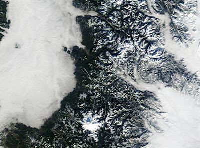
Today, we had pools of cool area in both eastern and western Washington, the latter is relatively unusual, but cold air in the basin of eastern Washington during the winter is par for the course. In both, the cold air was associated with fog and low clouds. Take a look at the high-resolution MODIS imagery for yesterday, centered on Snoqualmie Pass. Pretty impressive. You can see the clouds on both side, snow over on the mountains, and the big white mass of Mt. Rainier in the lower middle portion of the picture. Look closely and you will spot fingers of fog-laden cold air moving up the valley from Ellensburg to Cle Elum to the eastern slopes of Snoqualmie. Why were low clouds pushing in from the east and not the west? Easy to answer. Today there was a moderate offshore pressure gradient (higher pressure to the east of the Cascades than to the west, and that pushed the low clouds eastward.
So at Easton, well east of the pass, they were in solid clouds:


And a model vertical sounding of wind and temperature at this time at Stampede Pass (about 10 miles east of Snoqualmie) shows the thin, cold easterlies (red is temperature, the x axis is temperature, the y axis is pressure, 850 is around 5500 feet, 700 around 10000 ft):


Fascinating and informative. Love this Blog. Keep teaching Cliff. You are a gifted instructor.
ReplyDeletebut good grief, enough already! I thought today was supposed to be party cloudy.. we are socked in and it's frozen outside (colder than yesterday) on Beacon Hill!
ReplyDeleteI didn't know about the temperatures above the inversion layer until this post. The only thing I don't understand is: Do temperatures return to the normal altitude model after the inversion layer is over? Or do I need to go to a higher altitude to avoid freezing my tuchis?
ReplyDeleteI experienced a similar inversion while skiing at Jackson Hole. It was -40F at the base of the lift and +5F at the top of the tram some 4400 vertical feet higher.
ReplyDeleteBazaar weather...time to shop? Great posts. Loved the helicopter line.
ReplyDeleteThe other thing that was really interesting about all the fog was that it was only raining underneath the trees. I assume this is more normal in the forests of Northern California.
ReplyDelete