High pressure or ridging, as meteorologist often call it, should be be associated with sunny, fair weather, right? Not over the NW lowlands in winter in many cases.
High pressure IS generally associated with a lack of heavy or moderate precipitation and the absence of storms, mainly because it is associated with sinking air. Sinking air is poison to storms and is associated with warming aloft, sinking air is compressed as it descends (pressure increases towards the surface, of course).
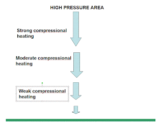
High pressure in the winter often brings low level inversions, where temperature warms with height. Why? As shown by the diagram, the sinking associated with high pressure has to decrease near the surface for the simple reason that air can't move through the surface. Sinking is stronger aloft and thus compressional heating is stronger aloft. More heating aloft and less near the surface helps to build an inversion.
But there is another reason. Sinking air aloft kills middle and upper clouds. That allows the surface to radiate infrared heat to space, thus cooling it. With a heater aloft and a cooling mechanism near the surface you get an even stronger inversion.
What about heating of the surface by the sun during the day? That would work against an inversion. Unfortunately, our solar heating is very weak during midwinter and, of course, during our long mid-winter nights there is no solar radiation. Inversions can thus easily form over night.
And then we have a further detail. Fog and low clouds can form near the surface during our nights as the air cools to the dew point. Clouds are highly reflective of solar radiation, but emit readily in the infrared. Thus, they are cooling machines (reflect solar energy, but emit infrared radiation) and help to protect the low-level cool layer and thus the inversion.
Inversions are very stable zones, meaning they work against vertical mixing. Think of a a dense fluid beneath a lighter one, the dense fluid likes to stay on the bottom. Cold air is dense and warmer is lighter.
So high pressure helps produce fog and low clouds and inversions. During the summer, nights are short enough and the sun's rays are strong enough that sufficient warming gets to the surface to heat the ground, evaporate the clouds, and destroy the inversion. During the winter we can get stuck in inversion/low cloud conditions, sometimes for days.
 |
| Inversion of Seattle on Saturday over Seattle. You can see the cold air layer (about 300 m thick) capped by a strong inversion. |
 |
| WRF model cloud forecast for 4 PM |
 |
| Visible Satellite Photo at 4 PM |


Fascinating ; and foggy at 110'0 feet this Saturday morning at 1130 am, near North Bend, Where the fog is 'clinging' to Rattlesnake Ridge. But at least we aren't shoveling two feet of snow. I have noticed over the last 40 + years that weather prediction has improved considerably here in the Seattle and Puget Sound area on the whole. In addition to more Supercomputing time, what are the highest priority tools you need. I will pester our Congressional and Senate reps for those items. There must also be spin off benefits from mproving meteorological prediction; like the benefit spin offs from the apace program or the sprread of economic benefits of building jets here in our state.
ReplyDeleteVery informative. The inertia of the setup explains why here in Tri-Cities these things are tough to scour out. Looks like one may be setting in starting tonight.
ReplyDeleteLast Saturday I flew from Dallas to Seattle in the afternoon. It was sun and blue sky all the way, over Telluride, Salt Lake, Boise, Tri-Cities. Then we came over the cascades and at the base of Mt. Si was a layer of cloud, like in your photo, extending to the Olympics. 1700 miles of clear skies, and then into the soup at Sea-Tac.
ReplyDeleteThanks for helping me understand why we are sunk in gloom again - another high pressure! (Finding synoptic charts, as we call them in Oz is hard in the States!)
ReplyDeleteLast year around this time we had 60 degree weather. Was that because we had a low pressure system stall off the coast and generate an offshore wind?
ReplyDeleteAnd February is one of the worst times to forecast inversion conditions, because the sun angle's just strong enough to put us on the "edge" of inversion-friendly mechanics.
ReplyDeleteOne thing I've ALWAYS wanted to see is an extremely stubborn blocking ridge to stay over us for the majority February, and see if an inversion can morph into a false spring just by the sun angle gradually increasing over the course of 2-3 weeks' time.