Sometimes the radar shows nothing above a location and it is precipitating at the surface.
Why do these things happen? A number of blog readers have asked me these questions, so I will give a try to answering it.
Well, let's start with radar 101. When you see a weather radar image, the echoes on it are generally NOT at the same level. Radars scan in a circle (in azimuth), but the antennas generally have an angle with the horizontal (the elevation angle). For all National Weather Service (NWS) radars but one (and you will be very interested in which one that is) have the lowest angle as .5 degrees. After going around once, the radar tilts upward to the next angle (usually 1.5 degrees) and completes the scan. And so on. This is called a scan strategy and the figure below shows the typical scan of U.S. NWS radars.
Only one NWS radar can scan below .5 degrees...our new coastal radar at Langley Hill. Having a lower angle allows the radar to see farther...very helpful for getting maximum range over the Pacific. A lower angle gives more ground clutter (the radar beam hitting the surface), but this had not proven to be much of a problem for Langley.
You will notice from the figure that the beams curve upwards away from the surface. This is the result of the curvature of the earth and the bending of the radar beam by the changing density of the atmosphere in the vertical. So, 120 miles out the bottom of the beam is almost at 10,000 ft!! So when you look at a typical radar image, the things you are seeing are at different elevation...the farther from the radar, the higher.
You will also see that the beam gets wider with distance (beam spread). NWS radars have a beam width of about 1 degree as they leave the radar. You will also notice there is little coverage right above the radar ("the cone of silence"---a term that will bring a smile to the older ones among you who remember the TV comedy "Get Smart." Click here to see it.
With that information under our best, consider how you can get a radar image showing precipitation and experience nothing at the surface. Like yesterday for a few hours at Bellingham, WA. Here is radar image at 2:53 PM Sunday (or 2153 UTC/GMT). The radar image shows precipitation over Bellingham Airport (a few miles NW of the city).
The airport reported nothing (see observations below, times in GMT) at that time, with rain start at 3:21 PM.
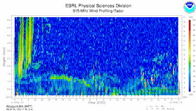
The reasons for the delay? Often the air at low levels is unsaturated (relative humidity less than 100%) below the clouds (the clouds are where the precipitation comes from, of course) and the precipitation evaporates on the way down, particularly if it light. Eventually the precipitation moistens and saturatea the below-cloud layer and precipitation reaches the ground. You can watch this process happen by viewing the output of another type of weather radar...ones that point vertically! Here are the radar returns from the vertically pointing radar at Westport, WA....time increases to the left and the y axis is height. You can see the precipitation (yellow and orange colors) descend down towards the surface.
The other possibility that I mentioned earlier is when the radar shows nothing, but it is precipitating at the surface. This happened during the past week when we had light drizzle that fell out of shallow clouds. In this cases, the radar beam is often too high to sense the precipitation. And the small droplets of drizzle do not reflect the radar beams effectively.
So radar is very useful, but it is not always a perfect reflection of the precipitation at the surface.


Thankfully having the radar beam(s) above our heads + The inverse square law for radiation where for every X feet the power is halved, we little people are probably very safe from this type of microwave radiation. Though it seems to me that some clever electronics at the receiver and display circuitry should be able to compensate for differing weather? The vertical radar is also a clever idea, though I would hate to be the seagull flying through that beam at radar level.
ReplyDeleteI am curious why the comments section of the blog does not appear on my iPhone app. I enjoy reading the feedback.
ReplyDeleteI love it when physics works (like it always does).
ReplyDeleteI'm not very worried about the radar energy, it starts out horizontal at the top of a tower, after all.
Unsurprisingly, we also see the same effects in atmospheric acoustics, which I have some understanding of.
I did know a couple of people who were stationed at the old "DEW" line in Canada/Alaska. No, you did NOT walk in front of their over-the-horizon antennas.
I worked on similar radar in the army. Felt guilty about radiating the German Farmer on his tractor. But with the Soviets playing cat and mouse, what else could we do.
ReplyDelete