
The reports of landslides, slope failures, and blocked train tracks has attracted a lot of attention by the news media this winter. Burlington Northern officials suggest this is one of the worst slide seasons in one-hundred years, with a particular focus on their tracks between Edmonds and Everett. Nearly 200 slides have occurred this winter, with 56 of them large enough to reach the tracks. On Sunday another slide stopped trains service between Seattle and Everett, after a very rainy day on Saturday. A huge slide on southern Whidbey Island has isolated dozens of homes and even Governor Inslee came to take a look. Yesterday, I got a call from a reporter (from KUOW of all places!) wanting
to know whether this was a symptom of global warming.
So what is going on? Is something unusual going on or is this some random bad luck? Could human intervention on the landscape be partially to blame?
Let's give this a look. Using the Western Region Climate Center's website, we can plot the percentage of normal precipitation for various periods. First, for the past 90 days, we see that most of the state has been quite dry, except for around Everett, where 100-120% of normal has fallen. A bit wet, but quite frankly, nothing very unusual
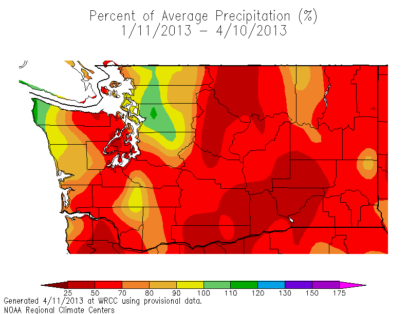
If we go back 6 months, the region around Everett stands out more, reaching 130-150% of normal. Yes, a bit wet, but I suspect we could find other periods to equal it.

As a next step, I plottedt the cumulative precipitation at Paine Field in Everett. For the last twelve weeks, it has been drier than normal (by about an inch).

We can plot the daily precipitation during that period against the daily records (see plot). Only one day (last Saturday), slightly beat a daily record. Not impressive.

Plotting the last six months, we see that the cumulative precipitation is substantially above normal (about 5 inches), with the big contributor being in November and December).


There were a lot of big rain days in November and December, with several daily records. We can plot the precipitation at Paine Field since 1 January 2006 (see below). November/December 2012 was clearly an unusually wet period.

I am not a geomorphologist, but it appears that the heavy precipitation in the fall set up the area for slides, even though the winter precipitation was not that unusual. Perhaps one o you can explain how this can happen.
Now there has been a lot of loose talk about all these slides having something to do with a trend in precipitation, perhaps associated with global warming. Well, let's use a tool on the Washington State Climatologist site to plot the trend of precipitation at Everett (see below). The trend is downward...it is getting a bit DRIER at this location over the past century. So no reason to expect increasing precipitation trouble in the near future for that area and no reason to place the blame on human-induced global warming.

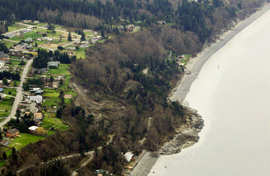
Another factor that should be considered is non-meteorological: the substantial disturbance to the slopes by development on its crest and folks mucking about on the slopes. Do vibrations from the trains have an effect or the drainage from impermeable surfaces on the top? Here is an example of exactly that (click on image).

All these slides provide another good reason not to send a lot of coal trains up that route. Can you imagine the increased vibration load of a massive increase of coal trains?
.png)


I have been wondering how long the BN and users of the rails are going to stick with this route.
ReplyDeleteI know it is fast and direct. The concept of a commuter system using trains is barely viable here , with low population and use. The regular shutdowns add to the poor prospect
and now the coal trains.
We know how the paving and housing on the top of the ridge can impact runoff, I would wonder how the vibration of train after train contributes.
Another good reason not to build 3000 condos below the Woodway bluffs at Point Wells.
ReplyDeleteVibration from trains almost certainly has an effect -- it can be felt for quite a distance from the tracks, and slides are sometimes triggered by passing trains.
ReplyDeleteWhen I briefly interned at BNSF, one of their operating rules was that any trenching operations near tracks were to be done using the shoring rules for unstable soils, because of the vibration effects.
These charts are from SeaTac, but the climate was likely not too much different in Everett. They show that, despite the relatively nice and mild winter this year, the first 92 days of the 2012-2013 water year (starting on Oct 1, 2012) were extraordinarily wet this year:
ReplyDeleteLast Twelve Water Year Starts - Small Multi's
Water Year Starts Sorted by Uh-oh's…
Water Year Starts Ranking Sorted by Year
Water Year Starts Ranking Sorted by Totals
Hmm...
Maybe we're simply seeing the effect of that autumn saturation? Trains vibrate the soil every year. But the slides appear much worse this year.
Cliff:
ReplyDeleteThanks for cranking through the data. The USGS has a landlide precip process they developed that I described http://washingtonlandscape.blogspot.com/2013/01/73-railroad-landslide-closures-and.html
The USGS has a site that you can go to that tracks a few stations including Paine Field. http://landslides.usgs.gov/monitoring/seattle/rtd/plot.php
The USGS issues warnings when the thresehold level is approaches a set value even a small rain fall event will push things over the top so to speak.
You are correct about those early big rains - they set the stage. Slope clearing and stormwater run off certainly doesn't help either.
This winter has provided an excellent test for the model and it was doing a good job of prediction earlier in the winter. Pehaps after this winter ends there will be some tweaking the model.
Note the model only applies to shallow surface slides.
A walk along the shoreline of Whidbey as well as other high bank shoreline will display part of the problem. Layers of sand, gravel, hard-pan and clay creates underground water flow which can undermine the high banks. The clay forms barriers like large saucers and bowls which can cause the water to collect and flow underneath the more porous sand and gravel. This is very visible walking along the shoreline and you can see the water flowing from this clay barrier.
ReplyDeleteToo much moisture can cause the soil to start sliding on top of the clay which also has a lubricating effect.Add strong vibrations then it gets things moving
So when we get heavy rainfall, the water collects between the soil and clay and away she goes.
This just the uneducated observations of a beach comber
I wonder about conditions at the toe of the slope and if there is any kind of erosion going on that would undermine the stability of the slope. When banks slide off into the water, they build a beach someplace else and this is a natural process of beach building When there are train tracks near the toe of the slope and rip rap and other unnatural materials there to stabilize the slope, I wonder what is happening below that as far as wave action and nature trying to reclaim the slope.
ReplyDeleteAlso there is probably a long term effect of septic systems, drainfield, diversion of ground water and irrigation.
ReplyDeleteOther factors being held constant, slope stability halves if the water column doubles (under the infinite slope equation). So heavy rain will doubtless load the dice. The local geology does not help, with the permeable Vashon till overlain the impermeable Lawton Clay. Sussing out how much megafauna activity contributes would require finding areas where the biosphere is undisturbed, then comparing slide rates between those areas.
ReplyDeleteOne of the likely culprits is changes in the tree canopy on the drainage area above.
ReplyDeleteWe know we're losing our urban forest canopy due to development. Some cities are making huge planting efforts to try and make up for this. In Seattle, the Seattle Department of Transportation manages more urban forest acreage than anyone else other than single-family homeowners (yes, more than the parks department).
The problem is when we replant, we're not planting conifers. We plant deciduous trees instead. This is fine most of the year, but it's largely useless for decreasing stormwater runoff during our rainy season. Why? Because during our rainy season those deciduous trees don't have leaves.
Trees prevent a great deal of rainwater from hitting the ground. Larger conifers each prevent a couple thousand gallons a year from hitting the ground. Instead, the rain stays in the needles and evaporates from there.
Seattle Public Utilities did a literature review and determined, for Seattle's climates, conifers are at *least* twice as effective as deciduous trees in terms of stormwater benefit. From my reading of the literature, I expect they're underplaying it a bit.
Want fewer slides? Want cheaper water bills (handling stormwater is EXPENSIVE)? Plant more conifers and convince your local government to do the same.
Has anyone considered the possibility that the root structures of the hillside vegetation have been shrunken and weakened from air pollution? Weakened roots won't hold the soil together very well. Ozone levels are high enough to cause significant root damage.
ReplyDeletehttp://witsendnj.blogspot.com/p/basic-premise.html
I live 3 blocks from the tracks in the Port Gardner neighborhood of Everett. I can feel the ground vibrating when those long, heavy coal and now crude oil trains pass. When I walk down by the tracks, the vibration is quite intense. I am surprised that there have not been a lot more slides since the coal trains have been running.
ReplyDeleteMy suggestion: Stop ALL train traffic on those tracks for 48 hours whenever it rains. If not, sooner or later we're going to have coal or crude oil loads spilled into Puget Sound. Better yet, just stop the passage of long, heavy trains altogether.