

Take a look at the "storm total" of the precipitation from Thursday to Friday morning based on the Spokane National Weather Service radar: 1-1.5 inches fell, with most of that happening within an hour or so.

The thunderstorm tops were so tall (about 35,000 ft) that they were picked up by the Camano Island radar (see image at 5:08 PM yesterday).

As an aside, I should note that radar coverage is very poor over the eastern slopes of the Cascades, with the radar beams from the Seattle, Spokane, and Pendleton radars being quite high (about 6000 ft!) by the time they get to say Wenatchee. Thus, shallow rain can be missed by these radars. The solution to this problem would be to secure smaller, gap-filler radars. Folks in Wenatchee, Ellensburg, and Yakima might lobby for decent coverage.
The heavy precipitation caused some of the rivers to rise very fast; here is an example of the river stage of the Methow River near Pateros. Nice spike from a passing thunderstorm.

Why the thunderstorms? Same old story...a weak upper trough moved through when potentially unstable air was over Washington (see upper level map for 5 PM Thursday below)
.gif)
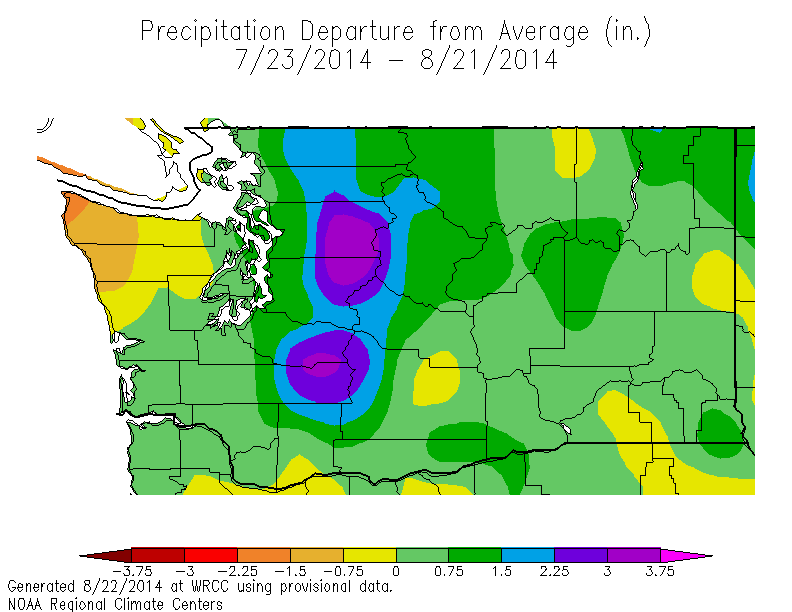
Let me give you an idea about how unusual things have been. Here is the departure from normal of precipitation over the last month. Except for the Olympic Peninsula, it has been wetter than normal and MUCH wetter than normal over the Cascades and eastern slopes of the Cascades.
.gif)
.gif)


Terrific thunderstorms in Yakima Co. today. While valley locations were spared, great day of chasing coming across several flash floods.
ReplyDeleteIt'd be interesting to know the volume of water that fell out of the sky today on this ordinarily dry area. Radar coverage is actually pretty good here but agree with the area in north central WA.