August 31, 2015

The Strongest Summer Storm In Northwest History

Saturday was a historic day during a historic summer.

On that day western Oregon and Washington was lashed by the strongest summer windstorm in its historic record.

A "perfect storm" that would bring respect during November ravaged the region, producing 40-50 mph gusts over Puget Sound, 60-70 mph gusts over NW Washington, and winds reaching 90 mph on the coast.   As the center of the low passed over Tatoosh Island, on the NW tip of the Olympic Peninsula, the pressure dropped to 986 hPa....extraordinarily low for August (see graphic)


This is the lowest pressure ever observed at this location in the historical record during summer, at least for the period (1984-2008) shown below.


Nearly a half million people lost power and even today tens of thousands are without electricity in the region (see map of Seattle outages at 9 PM Sunday).  Two people were killed by falling branches and several were injured.   Major roads were closed due to fallen trees. Damage is certainly in the tens of millions of dollars.

Power outages over a day later in Seattle

But the most amazing thing about this storm was when it took place:   the end of August.  

As far as my research has shown, there has never been a summer storm even close to this one for western Washington.   The most powerful summer storm EVER to hit our region.  A cause for wonder and amazement.  We are talking about a major midlatitude cyclone, whose winds and damage were spread over a large areas.

What is my basis for this claim?

I began by searching the most comprehensive site for major windstorm information, one created by Dr. Wolf Read.  My findings:  no comparable storm from May through September, in any year.

Then I went through all the coastal and buoy sites on the official NOAA site.


Nothing like it in the historical record at any of the WA coastal or NW Washington sites.

Consider Destruction Island on the WA coast.  The historic maximum gust  between May and September was 58 knots.  Yesterday, it rose to 78 knots.

West Point in North Seattle got to 48 knots yesterday.  The previous record was 38.5 knots  This was not only the biggest storm, but it smashed previous records.

Yesterday we experienced a radically different animal than we have ever seen during the summer here in the Northwest.   

 I know some folks will say this is due to global warming, represents the "new normal", or was due to the BLOB (the warm water off our coast).   At this point, there is no reason to expect that any of these hypotheses are true.  Climate simulations do not produce stronger midlatitude cyclones like Saturday's.   Natural variability can produce extremes and this is probably a good example.  I should also note the IPCC report on extremes (IPCC is the international group evaluating the impacts of greenhouse warming), had low confidence of any connection between global warming and changes in the regional intensity of midlatitude cyclones (like the one on Saturday).  A direct quote from their report Managing the Risks of Extreme Events and Disaster to Advance Climate Change Adaptation:

In summary it is likely that there has been a poleward shift in the main Northern and Southern Hemisphere extratropical storm tracks during the last 50 years. There is medium confidence in an anthropogenic influence on this observed poleward shift. It has not formally been attributed. There is low confidence in past changes in regional intensity. There is medium confidence that an increased anthropogenic forcing will lead to a reduction in the number of mid-latitude cyclones averaged over each hemisphere, and there is also medium confidence in a poleward shift of the tropospheric storm tracks due to future anthropogenic forcings. Regional changes may be substantial and CMIP3 simulations show some regions with medium agreement. However, there are still uncertainties related to how the poorly resolved stratosphere in many CMIP3 models may influence the regional results. In addition, studies using different analysis techniques, different physical quantities, different thresholds, and different atmospheric vertical levels to represent cyclone activity and storm tracks result in different projections of regional changes. This leads to low confidence in region-specific projections

But in the end it was perhaps fitting and expected that we had this storm.   The warmest and most unusual summer in Northwest history is capped by the most severe summer windstorm in recent record.  Large amounts of precipitation have quenched a dry landscape.   Air quality has been restored.  Many fires have been damped down.  A great anomaly requires a great correction. 

Yin and yang. 

Something to ponder.


Announcement
    If you are interested in learning about and helping the Washington State revenue-neutral carbon tax initiative, check our the  CarbonWashington web site.  The need signatures for the initiative and financial support.    I strongly support this bipartisan effort.

August 29, 2015

Extraordinary August Storm

This is perhaps the strongest August storm on record---certainly the most impressive in my memory.

  Here are the maximum winds during the 24h ending 9 PM Saturday. 87 mph at Destruction Island on the central WA coast.  Lots of 60-70 mph gusts from Everett northward, with 40-50 mph being common over the rest of the region.


And here is a close-up view of the Puget Sound area.  Note...the zero winds should be ignored.


Nearly a half million folks lost power...perhaps the biggest wind-related August blackout in regional history. Why so many without power?  Strong winds, first storm of the season, and dry conditions (which appear to make trees more susceptible to limb loss).

Want to see something really amazing?  Here is the maximum hourly gust at Destruction Island.

It peaked at 78 knots. That is NINETY MILES PER HOUR.

And what about precipitation?   Here is the 24h amounts for the same period. OVER 4 inches over the SE side of the Olympics, with1-3 elsewhere over that range.  This will have a huge impact on the drought conditions there.  1-3 inches over the north Cascades,which will help knock back of the fires in that area.  Heavy amounts over SW Washington.


But it is NOT over yet. A large band of very heavy precipitation is now over western Washington (see radar).


And the forecast precipitation for the next 48h is considerable (several inches) over the Olympics and North Cascades (see map).


And plenty more rainfall after this period.

The Coastal Radar Sees the Storm Center

There is some amazing imagery this morning.    First, the infrared satellite imagery around 5 AM.  You can see the swirl of clouds around the low center.  Just a beautiful, classic storm.  A very deep low center (around 990 hPa) for this time of the year.


But now the real treat....here is a recent (8 AM) image from the Langley Hill radar near Hoquiam. You can clearly see the swirl of precipitation around the low center.   We get these images roughly every 6 minutes and they tels us exactly where this storm (and others) are located.  An extraordinary tools for local meteorologists.  I should show this to Senator Cantwell, who played a major role in getting the radar.


The latest NWS HRRR (High Resolution Rapid Refresh) forecast has the low deepening as it approaches us (to around 988 hPa) and passing over the NW tip of the Olympic Peninsula (see forecast for 11 AM)

Seattle WindWatch is always a good place to check out high wind situations in our area and its display of the UW wind forecast shows strong gusts (greater than 50 mph) over Puget Sound, the coast, and over NW Washington.  Over 40 mph possible over Seattle.

Some of you will lose power....sorry.  Charge your phones and devices NOW!

August 28, 2015

Major Autumn Storm Approaching--In Summer!

It is enough to put shivers down the spines of true Northwesteners.   Finally, some real weather.   Heavy rain, wind, and, yes, I suspect some power outages.

For the fires in the Olympics and the Cascades it should be the turning point.

The satellite imagery Friday evening was impressive (see below).  Lots of clouds, and a potent low center is developing in the swirl of clouds west of the northern CA.


Today was just a very slight taste of tomorrow.  Here is the total rain as of 8 PM Friday.  3/4 inch in the Olympics and North Cascades. Only light rain over the Sound...that will change.


The models are forecasting a deep low pressure center (for this time of the year, for sure) to be poised to approach our coast a 5 AM tomorrow morning (see plot).  This map shows the pressure and temperature pattern...with a very large pressure gradient south of the low.


One of the best ways to forecast is to use ensembles---using many forecasts, each a bit different.  Here is the ensemble "plume" diagram for sustained surface winds at Seattle.  Each color is a different model wind forecast and the black line is the average...the ensemble average.   Wow.  The sustained winds get to around 25 knots, which means gusts will get between 30 and 40 knots.


The time shown is in UTC (GMT), so the peak winds will be between 11 AM and 2 PM.  I was going to go fishing tomorrow with Greg Johnson of Skunk Bay fame, but put it off based on this forecast.  The latest UW WRF model gust forecast for 11 AM Saturday is very windy, with crazy strong gusts along the coast and over northern Puget Sound.  If you were thinking of going out there in a boat, think again.

 With lots of growth over the summer and some branches weakened by drought, I suspect there will some power outages tomorrow.  My friends at Seattle City Light are prepared...they will even have some extra crews ready to go!

Precipitation?   Here is a plot of cumulative precipitation this weekend  at Seattle for the various ensemble members.  1-1.5 inches at Seattle over the weekend is a good bet.


The 24h precipitation ending 5 PM is shown below:  1-2 inches in the Olympics and north Cascades....and this is not the end of it.


To be amazed, examine the 72hr rainfall totals starting 5 PM Friday--some locations in the N. Cascades and Olympics are predicted to get over 5 inches of rain!  2-5 over a lot territory.  The Paradise fire is a goner...as are the fires around Nehalem.


Enjoy the weather...I certainly will.

August 27, 2015

Major Weather Shift Will Bring Substantial Rain And Help Bring Cascade Wildfires Under Control

The end of August often brings the entrance of a major weather system and a touch of fall, and this year will follow this pattern.

The atmosphere has been shifting into a different configuration the past week, and during the next few days a major transition will occur, with persistent strong troughing (low pressure) over the Northwest.  It will bring large amounts of rain to our mountains, knock back and end some of the fires, and allow firefighters to gain control of the situation for Cascade Mountain fires.   It will bring substantial water to reservoirs that have dropped to extremely low levels.

Want to be impressed?  Here is the forecast precipitation over the next 72h,  1-2 inches over that period for much of western Washington and the north Cascades.


 The next 72h?  As much or more over Washington's mountains.  The BC Cascades get hammered with 2-5 inches.


 Want to see a close-in view of WA precipitation for the 72h ending 5 AM Sunday?  The north Cascades and western slopes of the Cascades get hit very hard. This will have a HUGE impact on the fires along the eastern slopes of the Cascades.  Much of the Okanogan region will enjoy several tenths of an inch.


These storms should have a profoundly positive impact for the Cascade fires. There will be less rain over the Okanogan area and winds will pick up there (which is not good).  On the other hand, temperature will fall and humidity will rise over NE Washington.

So what is going on?  The persistent ridge that has given us warm temperatures and little precipitation has been shifting far out into the Pacific, leaving a series of troughs over the Pacific Northwest.  To illustrate, let me show you the upper level (500-hPa)  maps for several times for this weekend and next week.

Saturday morning:  trough over the eastern Pacific and big ridge to the west.


 Monday at 5 PM:  same general pattern.


 Wednesday afternoon, the trough has strengthened.


This change is not a one-day affair.  That is why it is so important.  It will end a chapter in this summer's fire season.  The latest NWS Climate Prediction Center's 6-10 day forecasts?   Much cooler than normal over the western U.S., with above-normal precipitation over the Northwest.


Fall is not here and eventually warmer conditions will return, but this will be the big break that many were waiting for--and expecting.   The strengthening El Nino is disturbing the atmospheric circulation in a way that is weakening the crazy-persistent West Coast ridge.  As I will explain in a future blog:  Godzilla El Nino will kill the BLOB.

Finally, I should note that the requests for water conservation have had a big impact here in Seattle, as shown by the accompanying graphs, folks are using less water and the reservoir levels have stabilized.  There will be some refilling during the next week.


August 25, 2015

A Great Source for Northwest Smoke Forecasts

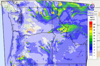
When I want to get the latest regional smoke forecasts, I turn to the modeling site run by the Laboratory for Atmospheric Research (LAR) at Washington State University, found here.  As you will see, they have created a major technological achievement combining atmospheric and air chemistry models for prediction of air pollution over the Northwest. The system is called AIRPACT-4 and is run by Professor Brian Lamb and Dr. Joseph Vaughn.

Let me show you a sample.  Below is the small particle forecast (PM2.5, particles smaller than 2.5 microns--millionths of an meter) for Monday at 1 PM.  The locations of fires are shown (red dots)...you can see the plumes of small particles produced by them (colors).  The worst conditions are over and downstream of the fires of NE Washington.  Another plume is coming off of the fire near Mt. Adams and heading towards Yakima.  I travelled to Yakima on Monday and let me assure you...this plume was there.  Some residual smoke over Puget Sound, but not as serious. Huge amount of smoke over NE Idaho and western Montana.


 Wednesday (today) looks better over Puget Sound, but still bad over NE Washington.  Not great near Yakima.


How does this system work?   They start with the atmospheric forecasts made by the high-resolution UW WRF modeling system, the one I often show on this blog.   They get information about sources of air pollutants (like fires, natural sources, industrial sources, transportation sources, and more), also known as emissions.  Specifically, smoke emissions information for wildfires comes from the US Forest Service's BlueSky system.  They feed this information into a sophisticated air chemistry model developed by the EPA called the Community Model for Air Quality (CMAQ) that calculates air quality for a region by treating the domain as a three-dimensional grid of cells of regular size.  This model then forecasts particle concentrations, as well as the amounts of various gases and pollutants (e.g., ozone, sulfur dioxide and more).  Pretty neat stuff.

Remember the smoke coming in to Puget Sound on Saturday?  The AIRPACT system nailed it. Lets look at the forecast from late Thursday.   At 3 AM Friday, the smoke was heading toward Spokane.

But as a thermal low developed with easterly flow, the smoke direction reversed, as shown by the forecast for 8AM Saturday, with western Washington getting into the murk.    Very nice forecast.


No forecast system is perfect, particularly such a complex forecast system that requires good emissions information, a skillful atmospheric model, and a realistic chemistry model.  The AIRPACT system is an impressive advance and the folks at Washington State deserve kudos for what they have built and run operationally.   Even considering they are Cougars.

August 23, 2015

Was the Fatal Wildfire near Twisp, Washington Predictable?

I have hesitated to write this blog, considering the sensitivity of the issue:  three brave wildland firefighers died trying to save lives and property.  But fires are still burning and others have their lives on the line, so I feel impelled to write this.

Many wildland firefighter deaths have resulted from inattention to meteorological data and forecasts. A tragic example is the Yarnell, Arizona fire in which radar showed developing thunderstorms that led to strong outflow winds that produced tragic results.   The firefighters should have been pulled out, something borne out by subsequent analysis (see my previous blog on this).

As I will describe below, I believe that the meteorological guidance for the Twisp fire situation was clear:  all firefighters should have been warned/pulled back because of the imminent threat of rapidly increasing winds accompanied by a change of direction.   I believe media claims of "unpredictable" winds are unfounded.


The locations of the tragedy was near the intersection of Twisp River and Wood Canyon Roads. More context is derived from a google map....I indicated the location.  The incident occurred west of Twisp, south of Winthrop, and east of Stehekin, found at the northern portion of Lake Chelan.


The time of the incident is not clear in the press, but initial reports of the accident appeared between 5 and 6 PM on Twitter.  I assume the timing of the incident is between 3 and 4:30 PM.  If someone has better timing I would like to know it.

Seattle weather radar shows evidence of fire blow up in the correct location at 22:54 UTC (3:54 PM).  You will also see the echo at 5:12 PM.  It is subtle...but look due east of the northern tip of Lake Chelan.  County boundaries are on the radar image...note how the fire location is found at the western location.


The fire is also clear in the visible satellite imagery, as is the radical shift of the winds and the blow-ups of this and other fires.  Here is the visible image at 8:30 AM that day.   The smoke is moving southward, pushed by the low level winds. No evidence of a major fire in western Okanagan County where the incident will happen.


At 12:30 PM, the general winds are starting to shift to the west, and not much is found over the future incident site.

At 3:30 PM, things are happening.   Fires have developed near the crest of the Cascades with a clear drift to the east of the smoke (strong westerly winds).  You can see the developing fire over eastern Okanagan County

 At 5:30 PM, the fires have revved up, particularly the one of interest.   The winds are clearly westerly.

Weather observations on the ground showed the transition to rapidly increased winds from the west and northwest.  Here is a trace of temperature, dew point, wind speed (sustained and gusts) and wind direction near Stehekin, upstream of the incident location.   Between 12 and 3 PM the winds surged from very light (less than 5 mph) to over 20 mph, as the winds shifted to just west of north.
Winthrop showed a big acceleration and windshift around 3 PM


I could show you more of these, but you get the idea....if anyone was monitoring the weather observations they would have seen a major wind transition (wind shift and wind increase) moving across the Cascades between noon and 3 PM.

But there was a lot more warning than that.   High-resolution computer models, such as the UW WRF model (which IS used by the fire and AQ communities), clearly showed the transition.   Let me prove this to you.  Here are the forecasts from a run initialized 5 PM THE DAY BEFORE.   Available many hours before the incident. These maps show surface sustained wind speed (gusts are higher) and wind direction (little barbs).   Lake Chelan, Winthrop, and the county boundaries are shown.

First, the 18-h forecast for 11 AM Wednesday.  Light winds (blue colors) generally and over the accident site.


The forecast for 2 PM shows winds increasing, including over the accident site, but stronger to the west,


 The 5 PM forecast is very threatening.  Sustained winds around 20 knots around the accident location, with a clear wind shift to westerly.

Thus, wildfire folks should have been prewarned of a major wind shift and acceleration and probably should have been pulled back that afternoon.

The cause of the wind shift was a westward moving disturbance.  Here are the winds above Vancouver Airpot that day (time in UTC increasing to the left.  19/18 is 11 AM).  There was a shift to NW winds aloft as the disturbance went past).

Today there is extraordinarily large amount of weather information available for giving real-time guidance and accurate short-term forecasts for guiding and protecting those fighting wildfires.  Rarely are there surprises anymore, except with thunderstorm initiation (and that wasn't occurring in this event).  

I believe the windshift/wind acceleration that occurred Wed. afternoon was entirely predictable.  It was not random, it was not extreme or a new normal.  My profession needs to work with the fire community to ensure such tragedies are prevented.

Another Northwest Bomb Cyclone with Localized Strong Winds

  Don't tell the media folks, but another midlatitude cyclone will be "bombing" off our coast today, with some local impacts. ...