You don't need to be a meteorologist to appreciate the message of the latest infrared satellite image for the NE Pacific (see below): a band of clouds stretching from west of Hawaii to our door.

And the forecast total moisture in a vertical column of air (column-integrated water vapor) for tomorrow at 4 PM shows the atmospheric river signature, with high values of water vapor coming in to us from the west.

Here is the total precipitation forecast by the UW WRF model for the next 72 (through Tuesday at 4 AM). 5-10 inches of liquid water in the WA Cascades and SE British Columbia. But only about a half-inch around Seattle to Port Townsend. (click to enlarge)

Less precipitation but still wet for the next 72 hr, with California sharing in the bounty.


Now, some of you will want to know about snow. Don't ask. The air will be relatively warm and the snow levels will be around 6000 ft. Rain will fall on the lower ski areas, like Snoqualmie and Stevens, but higher elevations should get some....here is the forecast for the next 72 h.

As shown by the graphic below (SNOTEL observations), WA state snowpack is now very close to 100% of normal, well down from where we were a month ago.
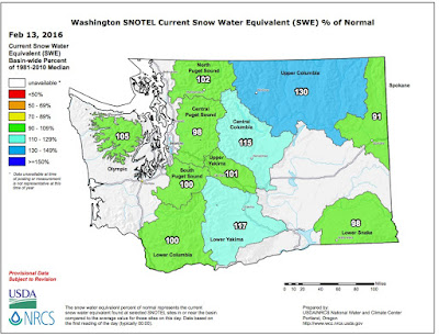
I suspect that with the continuation of the El Nino impacts we will slowly slide down to around 80% on April 1, hugely better than last year. The drought is over folks.
Northwest Weather WorkshopThe big local weather workshop is less than a month away (March 4-5, Seattle). If you are interested in attending, the agenda and registration information can be found here. This gathering is the place to be if you want to learn more about local weather research and operations.


What happened to the omega block -- it seems to have dissipated rather quickly. Why is that?
ReplyDeleteI think it was a fluke. If the Omega shaped ridge had formed in July when the Jet Stream is less energetic it probably would have been more persistent. I enjoyed the sunny, balmy albeit short lived weather it provided.
ReplyDeleteNow were back to drip, drip, drip. Not even my dogs want to venture outdoors.
"The drought is over." Absolutely, with continued precipitation especially. If it does flip to La Nina, this area won't be in drought for a good couple years, if it follows typical La Nina behavior. And that generally produces even more snow in the mountains. Good for us in WA and OR, but man, SOCAL.......not sure what happened there. I will take the rain, with warmer temps where I am. Better than constant snow and cold, like in December and early January.
ReplyDeleteWhat on Earth is a date shake?
ReplyDeleteCliff
ReplyDeleteA few weeks ago you had a blog post about how many people were complaining that we really did not have "EL Nino" conditions this year. You posted back that on the contrary the weather patterns to date were very consistent with an El Nino, namely warmer and somewhat drier than a normal year. The temperatures look to be in agreement but what about all our precipitation?
Thanks for your thoughts.
Michael
Mitch,
ReplyDeleteA date shake is a combination of dates and ice cream that is blended in a mixer...very sweet..cliff
Heavy rain east of the mountains the last couple days. Soil in the dry land farm areas is now out of drought after a really bad year last year.
ReplyDeleteMichael: Up until the last week, it had been cold and wet where I am (Central Washington). Pretty crazy as well, that last night I had inches of snow still on the ground and this morning it had mostly all melted. I think people were complaining that contrary to most predictions, the weather had been anything but El Nino-like here in Washington. I mean it does appear to now be more on the mark, for the temperature forecasts of the season. However, this area is supposed to get another huge round of precipitation, probably the 3rd or 4th atmospheric river in the last 3 months, which is really weird. I think a lot of places are going to end up above normal in precipitation for the 3 month period of December-January-February. This is quite a bit different than what the forecasts called for: Dry and mild. Temps are going mild, but it is supposed to be quite wet again. Because of all the storms here, our drought is so much improved, a real good thing, but SOCAL is probably not going to get what had been forecasted for rain this winter. Though it could in March, you never know, looking unlikely today.
ReplyDeleteMatt
ReplyDeleteThanks for your thoughts, here on Orcas Island we too are very wet and mild. The last 24 hours alone has produced 1.75 inches of rain....all my outdoor surfaces are buried in moss!
It is a total swamp in Port Townsend! Over 2 inches last night in thehe rain gauge. That's 10% of our annual average!!!!
ReplyDeleteRecord rain this season?
Where does one find the 2015 totals.. Several years above average now.
No shortage here. Maybe extream wet season and extream dry season but yearly totals have been way above average... Best I can tell.
I would like to see more blogs on weather locally....
Washington.. Not California. Point is western Washington never had a drought, and now eastern Washington is catching/caught up on precipitation too.
ReplyDeleteMicheal: Like anything, too much can turn into a bad thing. There are flood warnings all over Central Washington, King County, and other areas. The snow, and there was a foot on the ground just 2 weeks ago, has substantially melted making the issue of floods much worse. I hope with cooling temps as the week goes on, the rivers go down. However, with more rain predicted, this might not be the case for a few more days.
ReplyDeleteSome stats comparing Washington to California:
ReplyDeleteSan Diego: 6.06” (water year average to date = 6.24”)
Los Angeles Downtown: 4.20” (average 9.10”)
San Francisco Downtown: 13.70” (average 15.77”)
Sacramento: 8.92” (average 11.79”)
Portland, OR: 32.33” (average 20.98”)
Seattle, WA: 35.37” (average 22.91”)
As you can see it has been amazingly wet here in Washington, and it has been hit and miss in California.
My impression,from what Dr Mass said on this blog, is that he was referring to Washington state when he said that "the drought is over". He did then go on to mention how dry California is.
ReplyDeleteI am very surprised by the lack of precipitation in SOCAL. Historically they have gotten a lot of moisture in El Nino years. But there is always March I guess...... At least we have gotten our share and then some here in Eastern Washington.
ReplyDelete