
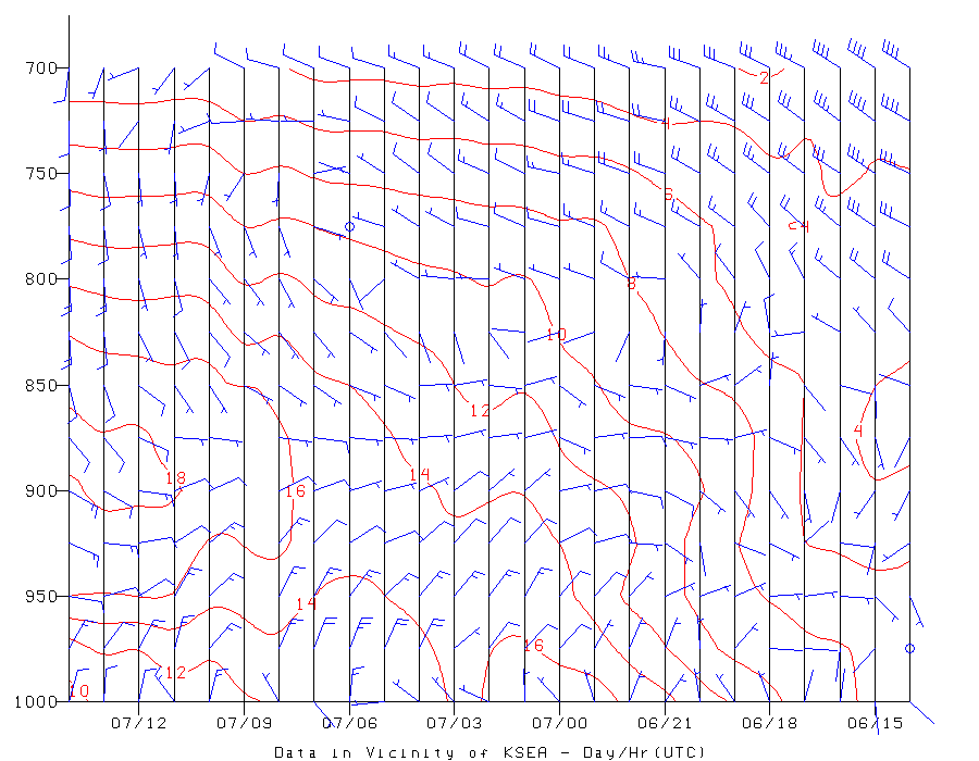
So the air over us is amazingly warm. And to add to it, the flow aloft is now easterly and thus offshore, which isolates us from the marine influence and produces downslope warming. Here is a plot of the temperatures and winds above Seattle-Tacoma Airport for the past 24 h. (time in UTC on x axis, pressure on y axis, 700 is about 10,000 ft). At 850 hPa, the temperatures have warmed from 4 to 18C, a 14C (25F) jump. Extraordinary.
It is going to burn today. UW Probcast (www.probcast.com) is going for 85F in Seattle. What could modify this warmth is if cooler northerly flow modifies the temperatures at lower elevations...which is possible if the easterly flow is not strong enough. Then we would end up in the upper 70s. Current models tend to mix air in the vertical too much, so they tend to overpredict temperatures in this situation.

So far, temperatures are moderate at low levels because the warm air is above us (see plot), but when that air mixes down, expect temperatures to rocket up. I am looking for my shorts.


Hi Cliff,
ReplyDeleteIt feels like there will be a bunch of diurnal records broken today. There appears to be a lot of locations in the foothills that went down to 37-41 degrees last night and that are now above 84 - crazy daily changes!
Kevin
It was 85 in Portland today! Earliest 80 degree day on record for April. Until I moved down here, I never realized that Portland was 5 to 10 degrees warmer in sunny weather than the Puget Sound area.
ReplyDeleteCommenting in the evening, it looks like you were spot-on with your suggestion about the northerly flow below keeping it a bit cooler than predicted. What a nice day, though!
ReplyDeleteMartin P (Bellevue)
This comment has been removed by the author.
ReplyDeleteOnly 70 at the Admiralty inlet.
ReplyDeleteTalk her is still about the standing water and mosquitoes from the wettest winter ever. Yep old timers never saw it so wet.
Organic Farmer: It will be especially bad for a few months in the hills and mountains, places where the deep snow is going to take a long time melting. I remember years ago being high in the Manastash Ridge/Canyon area, somewhere just east of Quartz Mountain, out in the trees. And there was still un-melted snow in the trees and this was June, with massive amounts of mosquitoes; it was awful frankly. I expect some places to be snowy in deeper foliage, even in July as the higher elevations, about 4500 feet, just got pounded with feet upon feet of snow this winter.
ReplyDelete