And to be honest, I give short-shrift to normality in the blog, since I love to talk about the unusual, the extreme, and the interesting weather situations.
But today I am going to break the mold and tell you that for the last week the weather has been excruciatingly normal. Boring to some, perhaps.
Take temperatures at Seattle Tacoma Airport for the past week (see chart below with normal highs and lows in red and blue, respectively). Pretty typical stuff.
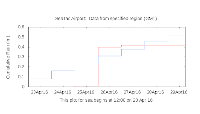
Sea-Tac precipitation? The actual (red) is within .1 inches of normal during the same period. You are probably starting to yawn.
Clouds...plenty of them, with a few breaks. Totally normal in late April.These normal conditions are found throughout the state. For example, Pasco's temperatures during the same time are.....completely typical:
The famous U.S. Drought Monitor: no drought in our State, except for some slight dryness over the far southeast.
The official Climate Prediction Center precipitation forecast for the next 3 months for Washington? EC (equal chances if above or below normal)....which means a forecast of normal.
This is simply maddening.... normal is not good for the weather business.


Nice article, Cliff. I particularly like the fact that the lows this past week have been at, or above, average. When I gamble, and put my tomatoes in the ground during an early April warm streak, such as we had, it is nice to not have below average low temps later in April. My tomatoes are doing well. This coming week looks helpful, as well.
ReplyDeleteI may plant the corn today. I sure hope this coming week's forecast holds. Corn, as I am sure you well know, requires very warm soil to germinate.
Sure, laugh it up... I read that everyone alive today will be dead in 120 years from global normaling.
ReplyDeleteInteresting article but a few days doesn't make a trend. Its been very warm here in the Methow valley. According the Winthrop weather station, April has been 6.6 F above average (as of 4/28). Stream/river flows appear to have peaked nearly a month early. Nearly every day has seen a new record flow for the Chewuch river (tributary to the Methow). On April 1 the snowpack in the upper Columbia river basin was 134% of normal. As of April 25th, the snow pack in terms of water content had dropped to 63% of normal. Looks like another hot, fire prone summer awaits us.
ReplyDeleteProf. Mass,
ReplyDeleteI saw this:
http://www.hcn.org/articles/across-west-april-storms-last-chance-for-snowpack
"At the beginning of April, snowpack levels across the region were “near normal,” says Cara McCarthy, deputy director for the National Water and Climate Center in Portland, under the Natural Resource Conservation Service. The season was off to a slow start with sporadic storms in October through December, but January winter precipitation increased levels across all states, according to NRCS SNOTEL sites, which measure snow depth at thousands of stations nationwide. For months, most of the region hung on to above-normal snowpack measurements.
But in just the few short weeks since, that snow is melting faster than climate hydrologists have seen in nearly four decades, bringing the snowpack far below normal in most states in the West."
Hi Cliff,
ReplyDeleteI suspect that you can argue that "normal" weather is very abnormal, except perhaps in Southern California.
Because we live on a planet with vast oceans and atmosphere that are never in complete equilibrium, our weather has great difficulty being exactly normal.
But looking on the bright side, if our weather were always normal, we would have little need for meteorologists!
See you in Portland next month!
Gordon
Deek: Snowpack is very important, but the sheer amount of precipitation this winter helped in several ways. The Cascade reservoirs were pretty much full before any snow started melting, and apparently because of melt, irrigation is going full, which is a little early, so maybe that is troubling. But the bright side is that it is forecast to be normal, for the water situation at this point. Last year the reservoirs were half empty already at this time, there was no snow on Snoqualmie Pass (there was barely any on Snoqualmie in February 2015 frankly), and now there is still a decent amount of snow to melt off the hills.
ReplyDeleteThis link is an article talking about the Washington water situation. http://www.ecy.wa.gov/drought/ One thing that is pretty crazy was the statement that October-March was 40.5 degrees on average, and this was 4.7 degrees F over 20th Century averages. I know that where I live, it was a little below, mainly because of very strong cold spells in late November, late December into January, and late January. I think the snow on the ground was helping keep the temps down here, and making foggy days which were always cold. There was one point it was 2 feet on the ground. I know the snow was on the ground from the middle of December to the 15th of February. Crazy but on Valentines night it really got "hot" as in a chinook wind and melted all the lower lying area snow. Sorry that was long, but right now, the water situation is good. If we are going into La Nina, I could see a similar winter to last year, maybe a tick more precipitation, but not much more; it was really wet this last winter. Not sure if the cold that comes with La Nina will happen this year though, due to warming temps.
I for one welcome our new normal cloudy overlords.
ReplyDeleteI love "normal" because it does not normally happen, or as often as most think.
ReplyDeleteCliff still thinks the drought is over and everything is normal.
ReplyDeleteWhat's normal about climbing back into the 80's for the third time in April? High pressure just keeps rearing it's head over and over very early this season. Even the NWS has expressed concerns of these early persistent mid latitudinal blocking highs. Just normal folks!
ReplyDelete