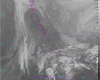
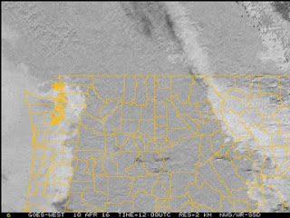
This morning we awoke to low clouds over the eastern Pacific and across western Washington/Oregon to the Cascade crest (see visible satellite picture at 8 AM) as a result of a weak push of marine air.
But when did these clouds move in? At night low clouds are invisible in most satellite pictures. Obviously there is no sunlight. So visible satellite imagery, like the above, shows nothing.
Then there is infrared satellite imagery, which is what you generally see on TV. Infrared imagery is based on the temperature of the clouds and surface (they use the emission of infrared radiation, which depends on temperature). In an infrared image, cold (generally high) features are shown by light colors, warm (generally low) by dark colors.
Here is the infrared image at 5 AM. You really can't see any low clouds over us. This makes sense, because low clouds are...low.... and thus their temperatures are very similar to the surrounding ground (dark or warm). So they are nearly invisible in the infrared.
But wily satellite meteorologists have found a way to deal with this problem: fog imagery! The National Weather Service geostationary satellites have imagers that observe the planet in a five wavelengths. One is visible and two are classic infrared. There is a water vapor channel for observing the distribution of water vapor in the atmosphere, and a short wave infrared channel, with an intermediate wavelength (around 4 microns, millionths of a meter for you tech-oriented folks).
It turns out that by looking at the difference in emission between the infrared and short wave infrared channels one can determine the location of fog and low clouds. More specifically, there is a significant difference in the emission of infrared radiation by water droplets between the infrared and short-wave infrared wavelengths; thus, the difference can be used to determine where water clouds are found (and low clouds are inevitably water clouds in most areas).
Let me show you the fog imagery at 5 AM this morning. Can you see that whiter shading over western WA and Oregon as well as the eastern Pacific. That is fog and low clouds.
Better get used to clouds. These week will be cooler with occasional showers. I will regretfully be putting my summer clothes away for a while.


This presented a bit of a problem for my flight into Seatac from the east coast yesterday morning. We left on time expecting clear skies. An hour or so before landing, the pilot announced that there was "unforecast fog" and one of the runways was closed. I can't complain too much, though, because ATC had us fly in a circle over the Cascades. Normally you have to choose between a great view of Mt. Rainier and a great view of Mt. Stuart, but not this time.
ReplyDeleteThis is what I use for watching the fog while at work here at Alaska Airlines.
ReplyDeleteWe were traveling north on highway 97 towards Bend, OR yesterday due east of Crater Lake when we drove under a very large thunder cloud and the rain was very heavy. Then what seemed to be 'snow globs' started falling very hard; this was not hail (did not bounce)and certainly not rain. The globs left a temporary white residue on the windshield and along the roadside there appeared to be wet snow though nothing on the road. The temperature dropped from the high 60's to about 39 degrees for a few minutes. After we left the storm the temperature rose 25 degrees in a few minutes. Quite an experience; I have never seen 'snow globs' like that before. Any comments? Regards, Gary Smith
ReplyDeleteIt could've been graupel. Soft hail that looks like snow globs.
DeleteCliff - sorry for the off-topic but I did not see any contact info on your page.
ReplyDeleteThis article about Panasonic looks interesting - from Ars Technica
http://arstechnica.com/science/2016/04/tv-maker-panasonic-says-it-has-developed-the-worlds-best-weather-model/
Off topic message
ReplyDeleteCliff-
An article about NOAA forecasts in a local sailing blog that might be of interest to your readers.
http://threesheetsnw.com/blog/2016/04/noaa-will-no-longer-yell-forecasts-at-us-in-all-caps/
Sorry for using the comments section on this article but I couldn't readily find another way to send this to you.
Scott Boye, Friday Harbor
@at Gary - maybe gropple.
ReplyDeletevery hard; this was not hail (did not bounce)and certainly not rain. The globs left a temporary white residue on the windshield and along the roadside there appeared to be wet snow though nothing on the road. The #musictherapy
ReplyDelete