A double low center is moving through today, with a weaker low last night and its stronger sibling during the next few hours. In fact, the infrared satellite image around 10 AM showed the second low center quite well--you see the swirl east of the Strait of Juan de Fuca? That's it.

East and southeast of low there was cold, unstable air producing strong convection and thunderstorms.

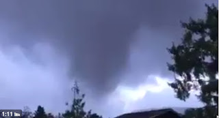
Some of these thunderstorm were very intense and produced rotation, with at less one tornado that hit Manzanita on the northern Oregon coast (see funnel cloud and damage picture below).

The winds last night and this morning (see below for the max gusts for the 24h ending noon Friday), gusted to 30-40 mph over Seattle, but much stronger of the the coast, where 40-70 mph gusts have been noted. Some power outages have occurred, showing our vulnerability with leafed trees and untested branches.

Winds are about to pick up around Puget Sound, as the the low center shown above moves north of Puget Sound. Perhaps 30-40 mph gusts over land, 35-50 mph over and near water. A few more power outages.
But the big storm will be tomorrow, late afternoon and evening. The noon infrared satellite picture shows the feature (inside the white oval).

I have looked at the latest forecast model output and they are all on pretty much the same page, which increases forecast confidence substantially. The bottom line is that we have a dangerous storm, comparable to the 2006 Chanukah Eve storm or the 1993 Inauguration Day Storm, one that is following nearly a perfect track to produce strong winds over the Puget Sound region. And the coast is guaranteed to be hit hard.
Let me show you the UW WRF version of this event, with an important note. This is going to be a relatively small storm. If the track of storm is shifted only a small amount (50-100 miles) from the forecast track, the winds in Seattle or other locations could be changed substantially. Thus, there is some uncertainty in the forecast.
At 5 AM Saturday, the low is off southern Oregon


Game time. This is when the winds would be strongest.

At 5 PM Saturday, gusts over 70 mph along the southern WA coast, south of the low center. No big winds over Seattle yet.


If the above solution is correct, several hundred thousand people in western WA will lose power. The key safety issue is to keep away from trees during the 4-6 hr of greatest threat. Typically, there are several deaths and injuries associated with falling trees, some of which occur when trees fall on moving cars.
I will be updating during the day tomorrow. Enjoy the storm but keep safe.
_____________________________
Public Service Message: I-732, the revenue-neutral carbon tax swap, will help reduce Washington State's greenhouse gas emissions, make our tax system less regressive, and potentially serve as a potent bipartisan model for the rest of the nation. More information here. Some opponents of I-732 are spreading false information, suggesting that I-732 is not revenue neutral. This claim can be easily disproven as discussed here. I strongly support I-732 as do many UW climate scientists.
__________________________________
_____________________________
New Weather Smartphone App, uWx
At the UW, we have developed a wonderful FREE weather app for Android smartphones that also collects pressure for use in weather forecasting. If you want to try it, please go to the Google PlayStore and download it.
At the UW, we have developed a wonderful FREE weather app for Android smartphones that also collects pressure for use in weather forecasting. If you want to try it, please go to the Google PlayStore and download it.


Thanks so much for this update. I assume what you're saying is "Plan on staying home Saturday night!" and I'm planning accordingly.
ReplyDeleteHi Cliff,
ReplyDeleteYou may have noticed the Bellingham vicinity is getting hit hard with winds this afternoon. A local reporting station in Edgemore reported a 78mph gust.
Looking at the obs on Vancouver Island, it seems like the storm made landfall at a slightly lower pressure than was forecast (975mb as opposed to the the forecast 980mb).
Kevin
Thank you for the updates! Does this mean its going to go right over Bellingham? Maybe just to the East of us? Thanks!
ReplyDeleteI don't have the luxury of staying home Saturday night. Some people have to work, even commute in the storm. But I will try to stay safe.
ReplyDeleteWhat are the prospects for Tacoma to get big winds, or is it aimed more for Seattle?
ReplyDeleteThank you. My son urged me to check you out, and I'm glad I did.
ReplyDeleteWhat about Oregon? Specifically Willamette Valley Area? Is it going to be like the storm of 62 like earlier thought?
ReplyDeletehttp://www.kptv.com/link/492613/fox-12-weather-blog
DeleteNot sure if you know what it might look like for south whidbey island?
ReplyDeleteThanks Cliff. Always a great level of detail and clarification of degree of certainty. With your blog on one tab and windytv.com for visuals on another, I'm in good shape--as long as the power stays on!
ReplyDeleteCould you speak a bit more about what you see when you look at the infrared image of the typhoon remnants (circled in the screenshot)? I'm asking because I don't understand what it is about the circled area that makes it stand out so much? I guess I expected to see more of an organization about a center or some indication of counterclockwise swirl. They look like they are upside-down mammatus clouds, which is pretty ominous, but what am I missing?
ReplyDeleteThank you!
Cliff?
ReplyDeleteThis week's Economist (cover date Oct 15 - Oct 21) has a decent article on I-732
It's also available on-line, but i don't know if it's behind their paywall.
Oh wow. I would hate to be driving along the gorge tomorrow
ReplyDeleteCliff, would be awesome to have an IOS weather app as well. Love the info you are providing. Thanks
ReplyDeleteThanks Cliff!!
ReplyDelete@ Rich Seymour - thanks for the heads up. I hadn't followed Cliff's advice to learn about I-732 yet. That got me started.
ReplyDeleteUnfortunately, while I don't really doubt the claim of revenue neutrality, the information in that article indicates I-732 goes much too far. The final tax level of $100 per ton is almost 3 times as much as the EPA estimates the social cost of carbon to be.
Not only is the proposal out of line with its intended purpose, it looks to me like it will end up being badly regressive.
Crunching some numbers, driving to work would cost an average of over $400 more per year per driver under this plan (more on a per household basis). Heating a typical home with natural gas will cost about $300 more. There will also be knock on effects to the cost electricity, food (which don't forget, has to be farmed and transported, which will consume fuel), and other necessities.
The increased gasoline and heating costs alone, weighed against a single percentage point sales tax increase, means that a typical household would need to buy $90,000 worth of taxable goods and services per year before their taxes are lower under this plan than under the current sales tax.
Sounds like a good deal for the top 5 percenters, and a bad deal for the rest of us.
Thks for blog. App referenced at bottom of page only Android? Apple boy feeling stepped on about now
ReplyDeleteNoted the NWS downgraded the maximum wind gust forecast to 60mph. 6:13 am central pressure was 982mb. It's further out to sea than the forecast map, too.
ReplyDelete
ReplyDeleteLooks like these storms will be 'DROUGHT BUSTERS'
Re naming the storm:
ReplyDeleteI like the last suggested name.
I would like to go further and suggest the name "Colin" after the chicken in Portland.
https://www.youtube.com/watch?v=ErRHJlE4PGI
R. Carter
I bookmarked this blog. Keep updates coming. Prof. makes weather interesting by refining large meteorological steak into bite sizes for the average weather illiterate
ReplyDelete