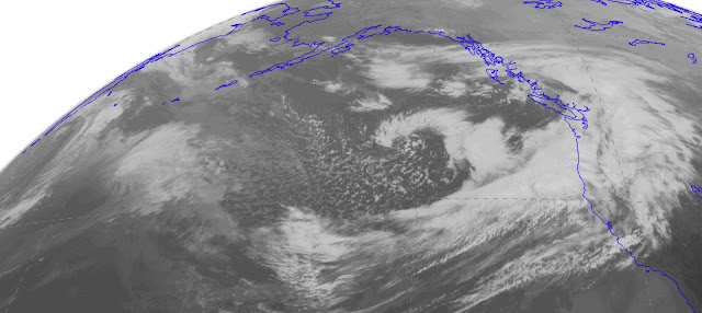
Currently, we have an atmospheric river (a relatively narrow current of moisture and precipitation) aimed right for our regio). This is evident in a recent infrared satellite image (see below)
Or in the forecast for the total moisture in the vertical valid at 11 AM. Blue is large amounts

Over the past 24 hrs (ending 9 AM), some locationz on the windward slopes of the Olympics have received 2-4 inches, with substantial amounts on the windward slopes of other terrain (like the N. Cascades.) (the figure below only shows locations with more than 1 inch)

Plenty of rain today, with greatest amounts over Oregon (see 24h precip ending 5 AM Friday).

Most of you are probably more interested in windstorms...so lets consider that now. Right now it appears that the late Thursday/Friday morning event will not be a severe one. One problem for that storm is that we are really working with an initially amorphous, almost double system, rather than a consolidated single strong system. Here is the surface pressure forecast for 11 PM...you can see the stretch out low, with lows of pressure gradient (and strong winds to the south).


But now, lets talk about what you REALLY want to know about. The Saturday storm, which potentially can be much stronger, representing the remnants of Typhoon Songda. The confidence in earlier forecasts were lessened by the different solutions of the US model (GFS) and the vaunted European (ECMWF) model--a classic situation for forecasts. The GFS was going for a historic storm with a central pressure in the 950s mb that hit Vancouver Island, while the ECMWF solution was weaker (960s) and farther south (passing over Seattle!).
Well, the new US runs have now shifted to a compromise solution, halfway to the ECMWF track and weaker, but still a remarkably intense storm for our region. And the storm is a bit later. Let me show you.
The surface forecast (sea level pressure) for 5 AM Saturday show a strong low (980 hPa) off southern Oregon.


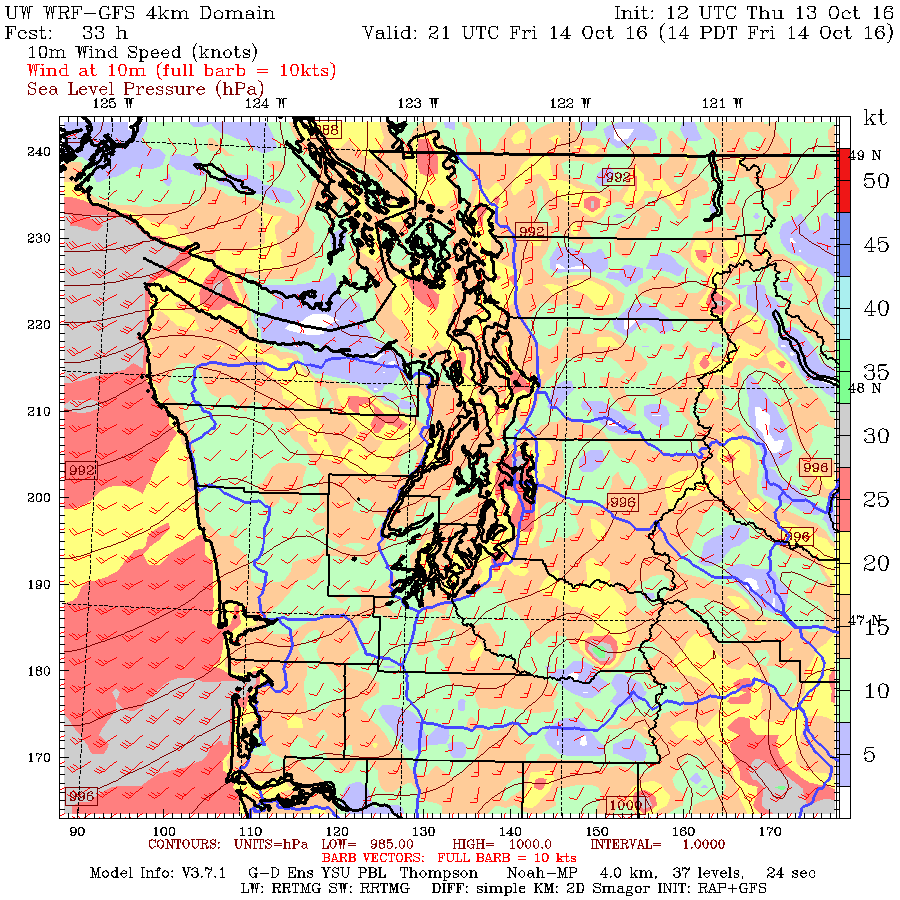
The wind forecast map (for sustained winds) at 11 PM Saturday suggest sustained winds of 25-35 mph, with gusts of 35-65 mph over Puget Sound.


Bottom line: the Saturday storm is the big windstorm threat and has the potential to be one of the strongest windstorms we have seen in a few years. There is still uncertainty in the forecast but it is far less than earlier.
Keep in mind what we are trying to do...forecast the exact track and intensity of a storm that is now thousands of miles away and currently very weak. If our track if off by 100 miles, the forecast is radically changed at nearly all locations. It is amazing we can even attempt to do this. So we still have to watch this system very carefully and update the forecast as we get close.
____________
I strongly support I-732, the revenue-neutral carbon tax swap, which help reduce Washington State's greenhouse gas emissions, make our tax system less regressive, and potentially serve as a potent bipartisan model for the rest of the nation. More information here.


Thanks Cliff! For the Saturday storm, is it possible to tell if it will be the San Juans or Seattle that would have higher winds? Wondering if folks in exposed island locations would be better off heading to Seattle. Thanks!
ReplyDeleteThanks Cliff! For the Saturday storm, is it possible to tell if it will be the San Juans or Seattle that would have higher winds? Wondering if folks in exposed island locations would be better off heading to Seattle. Thanks!
ReplyDeleteThoughts about wind intensities in NW Oregon, Portland area? It seems that the models are showing the low makng landfall further south than it was yesterday (around Long Beach now instead of VAncouver Island). That would seem to be worse for us down here in the Portland area.
ReplyDeleteI was kinda shocked by how this first low has taken shape in the last 24 hrs in the models let alone what may happen Saturday. Brace for uncertainty. If a model is trending in one direction, it's not done trending :)
ReplyDeleteHey Cliff,
ReplyDeleteCan you explain the units "cin" on the rain forecast map? I tried searching online but didn't come up with anything.
Thanks much!
Convective inhibition. The higher cin, the more thermodynamically stable the atmosphere is.
DeleteSaturdays storm:
ReplyDeleteThat's showing an incredible gradient of almost 20MB KPDX-KBLI, and an extreme KSEA-KBLI gradient of 12MB!
With a 974MB Low just over Vancouver.
This would be Inaugural day storm stuff, no?
This WRF-GFS also shows tonight's storm as a now show, and the NAM shows this staying over central VISL also. Interesting turn of events.
HRR and RAP still showing a decent blow tonight, but nothing that we don't see every year here.
So, basically, it's a non-event?
ReplyDeleteOk, starting to breathe again. I'm heading out to the San Juans today, returning Sunday. Looks like no problem getting there, let's see when I can get back!
ReplyDeleteThank you very VERY much for these forecasts & updates .... they are extremely appreciated!
ReplyDeleteSo, if I'm reading this right, the current projection is for a wet storm Thursday into Friday with high but not monster winds, probably a bit of a lull Friday night through Saturday afternoon, then a heavy windstorm Saturday late afternoon-evening.
ReplyDeleteDoes that seem correct?
Cliff, great info....trying to learn a crash course in reading your fabulous charts.
ReplyDeleteWhat does the carnation area truly look like for wind concerns-Friday night thru sunday noon??
A girl scout leader trying to decide if we still go camping.....
Not !! Lol
DeleteI would say, don't even think about risking it. One downed tree could ruin a lot of lives.
DeleteAwesome analysis. I took your Atmospheric Sciences 101 class at the UW in the early 80's (I believe it was your first year there). It was one of the best classes I ever took in school. Keep up the great work.
ReplyDeleteCurious how high the pressure will be on the eastern side of the mountains... as a long-time former resident of Enumclaw, any time I see the big lows coming in from the west I start to think about REAL winds.
ReplyDeleteThank you so much for all the good info, Cliff - Curious what the forecast for Sunday is looking like? Will the high winds likely be done by then?
ReplyDeleteYes, but what about the Seahawks on Sunday morning? Isn't that all anyone is *really* concerned about, after all? ;)
ReplyDelete@AlexLaCasse - you need to read his post again! Definitely not a non-event.
ReplyDelete@summerdavid - storm should be over in time for the game! Go Hawks!
for Unknown @ 11:15
ReplyDelete"cin" is supposed to be read as centi-inches (0.01"). So, if it gets into the neon green, that's 2/3 to 1.25" in the period shown, and black is 2.5 to 5".
Ellen, wind gusts late Saturday night are predicted at 30 to 35 knots, with 1" to 1.5" of rain at Carnation in the 24 hours up to 5 AM Sunday.
ReplyDeleteThis might be a case of discretion being the better part of valor. If you do go camping, it's likely to be VERY memorable.
To Unknown, "cin" is centi-inches. If you look at the graph headlines you'll see "Total precip in past 24hr (.01in)", so hundredths of an inch. The scale is logarithmic, by factors of two, so that purple band 128--256 means 1.28--2.56" for the period Thu 5am through Fri 5am.
ReplyDeleteI have been scouring he internet to see when/if Seatac airport is affected by high winds. We recently moved to the US Virgin Islands for a year (!) and my husband is escorting my parents back here Saturday night. Get this: their plane is scheduled to take off from SeaTac at 11pm. I can't seem to find airport closure info anywhere.
ReplyDeleteOn a separate note, as a huge weather nerd, I am beyond bummed to be missing this event! Hurricane Matthew did nudge is a tiny bit a couple weeks ago, but there is just nothing like a good PNW storm #HomesickForCoziness
If it makes you feel any better, you're not missing much. The forecast was exciting. The actual weather? Not so much. :/
DeleteCora,
ReplyDeletehttp://komonews.com/weather/scotts-weather-blog/sea-tac-airport-expecting-normal-operations-during-dual-wind-storms
Doppler indicated tornado down in Oregon this morning!
ReplyDeleteI live on Mutiny Bay on South Whidbey. In the very early hours of Friday, a super cell passed over my house, but luckily, did not touch down. I was watching TV and suddenly there was an extremely loud clap of thunder and immediately rain so strong that it sounded like someone had dumped a lake on my house(strongest rain I have ever seen in my 82 years as a Washington resident. within 30 seconds, it eased off to light rain.
ReplyDeleteBest Regards,
KR
BS in Atmospheric Sciences
UofW class of 56
Cliff, I think you meant to write that the storm center is southwest of the northwest tip of the Olympic Peninsula.
ReplyDeleteCliff, I think you meant the storm center is southwest of the northwest tip of the Olympic Peninsula, not southeast of the northwest.
ReplyDeleteWindless in Olympia
ReplyDelete