Eastern Washington will get out of the endless deep freeze.
Portland will finally warm up enough to rid itself of the icy roadways that have has made driving like a segment of Ice Road Truckers.
Western WA will lose the blue skies and bright sunshine that has been so pleasant for suffers of Seasonal Affective Disorder.
And tragically, Cascade skiers, particularly on the lower slopes, will give up powder conditions for the familiar Cascade Concrete.

Will the History Channel film a segment in Portland?
And there is a major threat tomorrow and in the Columbia Gorge: an ice storm from freezing rain.
The origin of our unusual cold has been persistent high pressure east of the Cascades that has brought cool, dry easterly flow over much of the region. A disturbance going south of that high gave Oregon the snow earlier this week.
To show you the changes, here are upper level (500 hPa) maps that illustrate the change. In the first (for 4 AM Monday), an upper-level ridge is right over us, resulting in dry weather over the region.


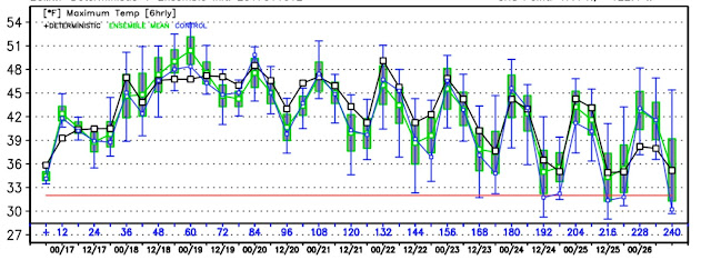
A HUGE change is going to occur over eastern WA and Oregon, which has been locked in the freezer for weeks. To illustrate, here are the temperatures at Pasco for the past four weeks (yellow lines), with the normal highs and lows indicated by the red and blue lines. For virtually all of 2017, Pasco has been well below normal, with the highs on most days not even reaching the normal minima, and a number of hours below zero F.


Seattle is already in the mid-40s and it feels so mild.
And did I mention precipitation? We are going to be very wet for the next few days, with the latest high-resolution WRF run suggesting that over the next 72 h as much as 5-10 inches of liquid precipitation will fall in the mountains--most of the that will be rain, except for the higher elevations of the Olympics and north Cascades.


Over the next 7 days, the National GFS model forecasts suggest a LOT of precipitation along the West Coast (see below), with 5-10 inches being common over West Coast terrain. As I will describe in a future blog, the West Coast drought is history. Good for veggie prices next year.


I've been wondering if the forecasted precipitation in combination with the temperature increase could cause landslides in western washington. Any thoughts? Thanks
ReplyDeleteI pray this transition is just a small blip on the way to a pattern reset. If this spells the end of winter for my area, I'm going to be extremely pi****!!!!
ReplyDeleteI love how cold it's been and the snowpack at my house (22") is beautiful.
-Someone that lives in Stevens County WA
Last year 2016 at this time, hellebores and sarcococca blooming. Not so 2017. Way behind.
ReplyDeleteIt would be nice if the MSM would reflect the reality of so much precipitation coming into CA, but for the most part they refuse to acknowledge that their multi - year drought is effectively over. The dominant meme of cataclysmic and historical drought must be maintained at all costs, it would appear.
ReplyDeleteLocal forecasts; they used to confuse me with Rain vs Showers (never thought about the difference)....but now they combine the words....
ReplyDeleteWhat's the point of the varying nouns they use for this water coming down?
ZONE FORECAST PRODUCT FOR WESTERN WASHINGTON
NATIONAL WEATHER SERVICE SEATTLE WA
947 AM PST TUE JAN 17 2017
FRIDAY NIGHT...CLOUDY WITH A CHANCE OF RAIN SHOWERS. LOWS IN THE UPPER 30S.
SATURDAY...CLOUDY WITH A CHANCE OF RAIN SHOWERS. HIGHS IN THE MID 40S.
SATURDAY NIGHT...RAIN SHOWERS LIKELY. LOWS IN THE MID TO UPPER 30S.
SUNDAY...MOSTLY CLOUDY WITH A CHANCE OF RAIN SHOWERS. HIGHS IN THE LOWER TO MID 40S.
I'm sitting in S Cal listening to the local TV weather guys. The public story is that the drought looks to be gone this year, with the next week's forecast rains likely to finish putting a stake through the drought's heart. That's the public and popular story. The one that drives household water usage trends.
ReplyDeleteThe problem is that many of the aquifers take many years to recharge, obviously the deep one's in the San Joachin, so they are still very vulnerable to gaps in the rainfall. Reservoirs are filling and this coming round of storms brings big flood worries if reservoirs have to release water because they are full. No flood control.
If reservoirs are full and aquifers are depleted, it may not be a drought, but they have no insurance to handle future droughts. Is this an anomolous year, or the start of a multi-year wet trend? I don't see anyone with the skill to make that call, so cautious consumption of water should remain the plan.
The challenge is to communicate that message of careful consumption without talking about drought worries.
And how good is the Colorado River watershed? That supplies most of the desert cities.
I do appreciate the higher humidity. Dew points below about 30F make me fell cold and dried out.
ReplyDeleteCliff/Eric, is that really accurate? Until the underground aquifers are full again, I would say there is still a CA drought. Will we stop seeing the phenomenon of land slipping down due to lack of water beneath it? I have often been curious what CA has done to prepare for this day...are they capturing all the runoff or is it going straight out to the ocean?
ReplyDeleteStrait!
ReplyDeleteTVN, there are programs/projects to spread and percolate storm water in the LA Basin. As you can imagine, it's difficult with so much much humanity (to "protect from stormwater") and so many impervious surfaces. But much of the opportunity is being realized in the upper watersheds which still have soft bottom channels. There are also many neighborhood projects that are being built to percolate water, using parks, or curbside bioswales to recharge aquifers and treat polluted runoff before it reaches the ocean. Though not a cure for the depleted aquifers in the San Joaquin Valley, it is a start and a model for other areas.
ReplyDeleteA first read on some of the work and planning: http://riverlareports.riverla.org/water-recharge/where-to-recharge/san-fernando-basin-study/
At this point, give me blue skies and warm sunshine. I've had enough of this freezing!
ReplyDeleteYou mentioned it a bit but would be great to hear more about how mountain passes like Snoqualmie or Stevens Pass will get freezing rain or a combination of freezing rain and snow even though the ground temperature can be in the mid-teens. Curious on how high up rain forms and what determines if it then becomes freezing rain or snow on its way down. Thanks.
ReplyDeleteTVN - If the aquifers are years behind since they've been depleted, then CA should be put on permanent drought conditions, in perpetuity. I'm being totally serious, CA has always been and will always be a dry state during most years, and since additional water reservoirs that were proposed in the 1970's and 80's were negated by the green lobby, there you go. The additional reservoirs were proposed precisely because the state water resource departments had estimated exponential population increases were coming, and coming soon. But their concerns were waved off and now CA is in a situation entirely of their own government's making. While there are certainly damns existing in the West and NW that are not needed anymore, the green lobbies used the Endangered Species Act in ways that were not intended, so now you have billions of gallons of fresh water going into the ocean and no reservoirs available to capture the runoff in water - flush years.
ReplyDelete