
Mega powder. The other ski areas received far less (like 6-8 inches at Snoqualmie and Stevens). Why so much at Mission Ridge? And how well did the models forecast it?
The key to the big snow is Mission Ridge's location on the eastern slopes of the Cascades and a relatively unusual circulation with moist easterly flow rising up along those slopes. As shown by the map below, Mission Ridge is on a ridge extending east-southeast from the central Cascades. The ski area is relatively high (5000-7000 ft).

Yesterday, a low center passed over and south of Washington State. To illustrate, here are the wind (barbs), temperatures, and heights (like pressure) at 850 hPa pressure (about 5000 ft above the surface). With a low centered on the Oregon/WA border, strong easterly/northeasterly flow was pushed right into Mission Ridge, with cold temperatures (blue color). That produced large upslope flow on the terrain of Mission Ridge, with lots of precipitation (which results from the powerful upwards motions).

The UW high-resolution model forecast initialized Sunday at 4 AM, did suggest heavy snowfall along the eastern slopes of the Cascades (see forecast of 24h snowfall ending 4 AM Monday), but it underplayed the amount (forecast only 8-12 inches).

Unfortunately, there is virtually no weather radar coverage over the eastern slopes of the central and northern Cascades, but the Pendleton, Oregon radar did show substantial enhancement over the eastern slopes of the southern WA Cascades (showing about 1 inches of water...about 10-15 inches of snow).

For the rest of us, we can look forward to considerable sunshine this week, as cold, arctic high pressure and easterly offshore flow spreads over our region. Sun is a great gift this time of the year and will gladden the hearts of all those tending towards seasonal affective disorder.
The latest European Center simulation suggests that Seattle will experience highs around freezing and lows in the mid to low 20s. Upper teens in colder spots of western WA.

I should note that the QUALITY of the Cascade snow this year has been excellent because of the virtual absence of warm/wet periods when we get rain on snow...and the resulting change of powder to Cascade concrete.
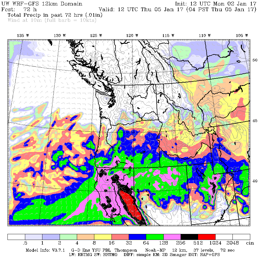
Ironically, our cold and sun will be accompanied by very heavy rain in California as the jet stream gets displaced southwards into Lotus Land. Here are the 72h precipitation totals ending 4 AM Thursday and 4 AM next Monday. Huge totals in the Sierra (5-20 inches). Great news for California water resources. Drought is rapidly ending there.


Hard to believe this is correct. If you look at the telemetry for Mission Ridge the 24hr snow total jumps from 18 to 34 in 1 hr while the total snow only went up by an inch. I can believe they received 18-20 inches (which is still impressive, but not 34").
ReplyDelete1-2-2017
Northwest Avalanche Center
Mission Ridge Ski Area, Washington
MM/DD Hour
PST Temp
F
6730' Temp
F
5160' Temp
F
4610' RH
%
6730' RH
%
5160' Wind
Avg
6730' Wind
Max
6730' Wind
Dir
6730' Hour
Prec.
5160' Total
Prec.
5160' 24 Hr
Snow
5160' Total
Snow
5160'
1/1 1500 7 13 16 88 100 43 55 53
.01 .01 4 25
1/1 1600 6 13 15 88 100 47 69 53 .01 .02 6 26
1/1 1700 7 13 15 88 100 51 66 54 .02 .04 6 126
1/1 1800 6 13 15 88 100 55 85 55 .02 .06 9 30
1/1 1900 6 13 15 88 100 44 88 55 .03 .09 10 32
1/1 2000 6 13 15 88 100 48 93 54 .02 .11 12 32
1/1 2100 5 12 14 87 100 46 105 55 .02 .13 14 34
1/1 2200 4 11 14 87 100 27 104 55 .02 .15 15 34
1/1 2300 4 11 13 87 100 23 98 52 .01 .16 16 36
1/2 0 4 11 13 87 100 22 95 52 .02 .18 18 37
1/2 100 3 10 12 86 100 14 92 54 0 .18 34 38
1/2 200 3 10 12 86 100 11 89 52 .01 .19 34 39
1/2 300 2 9 11 86 100 10 89 51 .01 .2 34 41
1/2 400 1 9 11 86 100 19 84 53 0 .2 34 42
1/2 500 1 8 11 85 100 46 81 53 .01 .21 0 126
In 2010 we had a cold blast for about a week before Thanksgiving. We already had a few inches on the ground but on that Monday night, around 6:00 p.m. it really started coming down. By 3:00 a.m. Tuesday morning we had 24 inches on the ground....in Eatonville. I totally believe they could have gotten that much in 24 hours.
DeleteHere on the front range in Colorado we call that an upslope storm (or in fall/spring, as informed by a 40 year resident, a new mexican left hook ¯\_(ツ)_/¯ ). As a far away spectator of the happenings in your neck of the woods i'm surprised that this sort of thing doesn't happen more often for the cascade eastern slopes. Any reason as to why that might be?
ReplyDeleteI just was there this morning. Definitely 39 inches of new snow!
ReplyDeleteAgreed, the ski area is clearly doing what ski areas always do, lying about snow totals. Their snow report even says their base and midway stations received 19 inches in the same 24-hour period, and since the temperature was well below freezing at all levels of the mountain, why would there be double at the summit where they reportedly received 39 inches? Regardless, impressive snowfall.
ReplyDeleteI was up there yesterday. It really was at least 30" deep. My 6' 6" ski buddy was up to his waist in snow pretty much everywhere. This wasn't random drifts either, I'm talking full runs of waist deep snow. If the ski area was lying, they did a good job of deceiving us.
DeleteLet me put it this way - the group I was skiing with are all ex-ski bums who have had multiple 100+ day seasons at mountains that get the deepest snow depths in the world (Mt Baker, Alta, Stevens Pass.) This was some of the deepest snow that any of us had skied.
Ski areas do not always lie about snow totals. I just couldn't let that comment pass.
ReplyDeleteSchrauf, if you were looking at the website you would have seen that the 19 inch number was for overnight, not for the 24 hour period. It was 27 inches in 24 hours at base and midway. It's not unusual for the higher elevations to get more snow, regardless of the temperatures. Base and midway are only 500 feet apart in elevation, but the summit is about 1700 feet higher than "midway". It was also below freezing down in Wenatchee at about 650 feet elevation, so by your logic they should have gotten the same amount of snow there since it was also below freezing. My guess is, the upslope component intensifies with elevation, hence the bigger number at the much higher elevation summit, and very little snow down in town.
ReplyDeleteI'm cynical about the amount to but I could believe it. It was a very dry snow so an inch of precip could probably dump 20 inches or more. Oddly with the cold and snow depth it's been a dry winter just east of the cascades with no NWRFC site registering above normal snow water content so this dump at Mission was greatly needed. It's been missing out.
ReplyDeleteHurricane Ridge got over 30 inches in the storm. Classic "lake effect" type storm. Sunshine over the Strait and dumping cold nonstop powder at the other "Ridge"
ReplyDeleteThere was as much snow as stated. Maybe more. I was there. It was a day for the record books. Some of the old timing locals up there yesterday said that it hadn't snowed that hard overnight since 1991.
ReplyDeleteInteresting to see the cold air going around the Olympics in the NE flow and converging off the Washington coast causing a long streaming cloud as it contacts the warmet Pacific water,extending far off shore.It's been visible for more than 24 hours now,in the same location.
ReplyDeleteI skied Mission Ridge yesterday from the beginning. While I wasn't out there with a measuring device, it was mid-thigh to waist deep. There wasn't as much accumulation at the summit, which I'm assuming was wind related. I don't know exactly where they keep there precip measuring devices, but most runs on chair 3, which is more wind protected were waist deep powder.
ReplyDeleteWhy didn't we get more down here then?? The faucet always turns off before it gets cold.
ReplyDeleteI was skeptical at first--the sensor at the top obviously did not catch the snow and melt it so that it could be read. But the NRCS snotel gauges around Mission Ridge show an increase of about an inch of water and the sensor at "Trough" which is at 5480' showed the snow depth at 14" on the 1st, and then some missing data, and then the big increase with a peak of 48" at 7am on the 2nd. It has since collapsed a bit and is reporting a depth of 36".
ReplyDeleteI looked at the Upper Wheeler sensor, and thought maybe just two feet of snow, but that is a little way from the ski area and I can imagine more fluff blowing in and settling in the bowl around the ski runs.
There is an article on the Wenatchee World, but I don't have access--but it mentions Cliff's blog here in the first bit that you can read for free.
Thanks for posting on his Cliff - as soon as I heard about this event I hoped you would!
ReplyDeleteAnd all, Mission Ridge, unlike Crystal Mountain, does not exaggerate snow totals.
The snow depth was real. I was one of the first who traversed over from Chair 4, pushing through waist deep, light powder. It was beautiful.
ReplyDeleteI was there too. Had a couple of face shots. Had to be pretty deep to do that... I've been smiling ever since
ReplyDeleteYeah I grew up in Ute Pass area 35 yrs ago and we called that an "Albuquerque Low" because of the usual proximity of the low pressure center when it sent up the "left hook" of moisture... Curious if they still call it that!
ReplyDeleteSo do you think we'll have the same repeat of "mega powder" on Sunday? Thanks!
ReplyDelete