As shown by the NWS analysis below, a huge area of very high sea level pressure is now parked over the western U.S. Meteorologists generally talk about sea level pressure (the pressure the atmosphere would have at sea level), because that gets rid of terrain effects. If we plotted station pressure, the pressure at the elevation of the observing station, altitude differences would dominate.
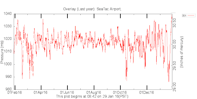
To give you some perspective, average sea level pressure is around 1013 hPa and we rarely get above 1030 hPa in a normal year. In fact, the pressure being experienced Saturday morning is the highest in over a year in our region. To show this, here are plots of sea level pressure at Seattle and Spokane, which is now around 1038 and 1043 hPa as I write this blog.
A number of locations in the west have or will exceed their January record sea level pressures. For example, San Diego and Bakersfield, CA have already beat their January pressure records.
At the periphery of the high pressure area there are regions of large horizontal pressure gradients (or differences in pressure over distance), which has produced some strong winds. Here is plot of the gusts over 34 mph during the past 24 hours. In the terrain behind San Diego winds are gusting to 50-80 mph, and strong westerly winds are descending along the eastern slopes of the Rockies and out into the Great Plains.
Closer to home, winds are gusts to 30-60 mph in the western portion of the Columbia Gorge, with the strongest winds at the wind Crown Point viewpoint (see map of Portland area gusts)
High pressure has been substantially influencing the water levels of our region--making them lower than expected. An illustration of this is the predicted and observed water levels at Seattle, WA provided by NOAA (see below). For some
times during the past few days, water level was nearly a foot lower than predicted. Why is this true? Localized high pressure actually pushes down the water surface. If you want to read a very nice account of the impacts of high pressure on Puget Sound, check out Greg Johnson's blog.
Enjoy the pressure and dry conditions today....tomorrow a weak frontal system will bring clouds and light rain during the afternoon and evening.


For such a strong ridge,the high is quite "dirty";for there are a lot of high clouds making it over,instead of dissipating.The strength of the ridge is also enhancing the temp inversion over here east of the Cascades
ReplyDeleteJohn: This is true. I can't stand this ugly end of January look east of the Cascades. Snow moving through is better than this flat ugly look in the basin and the Kittitas and Yakima Valleys. Low clouds and fog just makes things look bad, unless it raining and green grass is out like in spring. Hopefully things are mixed out early next week as is being predicted.
ReplyDeleteI'm mystified. I thought that high pressures meant clear skies, no rain. Yet, today is completely socked in, and the forecast is showing next six days with precip. What's up?
ReplyDeleteI was working on calibrating a RH sensor yesterday and I had to take a barometric pressure reading... and I was like "something must be wrong with my barometer"... Crazy high.
ReplyDeleteAll day it has been overcast. I had always thought that high pressure equated to clear skies.. today's unusually high pressure and simultaneous persistent overcast prove otherwise.
ReplyDeleteI just read an article by a British meteorologist about how forecasting becomes more difficult when clouds are trapped under a high pressure system. But it didn't explain the conditions which make this happen.
ReplyDeleteStarted getting pelted with large "corn snow" at 2:30 am in Glacier; heavy, quite like (not not quite) hail. CoCoRHaS WA-WC-70
ReplyDeleteEllen, that's called graupel.
ReplyDeleteIt commonly results when a thundercloud delivers subfreezing precipitation. It's common in the Rockies- not so much here but when it does, it usually happens in the spring when thunderclouds form over the mountains when the air is still quite cold.