March 30, 2017

A Beautiful Day on Friday After One of the Worst Winters in Years


Help Determine Local Impacts of Climate Change
Society needs to know the regional impacts of climate change and a group at the UW is trying to provide this information with state-of-the-art high resolution climate modeling.  With Federal funding collapsing, we are experimenting with a community funding approach.  If you want more information or are interested in helping, please go here.  The full link is: https://uw.useed.net/projects/822/home
_______________


The complaints have been non-stop, with even Northwest natives mumbling about one of the most persistently wet, cool, cloudy winters they can remember.

But tomorrow (Friday) will be better, with a transient ridge of high pressure over us, bringing dry conditions and temperatures rising in the upper 50s F.

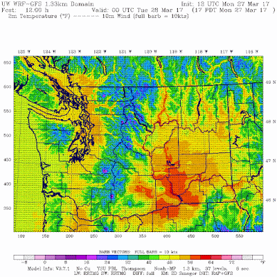
Here is the surface air temperature forecast for 5 PM Friday from the high-resolution UW WRF model. The dark orange (over Seattle) indicates 56-60F, with 60s in eastern WA and parts of southwest Washington.    I am looking for my sunglasses tonight.


But a single beautiful day does not make up for a challenging winter.  Before I describe it, did you you know that SmartAsset real estate site has ranked Seattle as having the most depressing winters of any major city in the lower-48 states?  This is based on the percentage of a sunshine rate and average solar radiation (see below).  Only far north Anchorage is worse for the U.S. as a whole.


So I guess we start with low expectations.  But this winter takes it one step further.  Here is the number of days during the past six months with at least a trace of rain.  115-145 out of 180 in western Washington/Oregon were wet.

But the real depressing aspect of this winter is the continuation of the clouds and rain into late February and March, when major improvement is normally observed.   Here are the number of days during the past 60 days with some rain.  OMG... large swaths have had 50-55 days of rain out of 60 days (83-92%).   This is way more than normal (typically in March in Seattle 55% days have some rain).  MUCH worse than typical.

One of the faculty in my department, Dale Durran, has a solar array on his house. This March had far less power output than any of the five years the system was in place.

All the moisture and clouds has resulted in very wet soils, something shown by the NASA GRACE instrument that can measure soil moisture from space (below).  Blue is highly saturated.  My backyard is a mud pit now.
Our future?  Some showers on Saturday, mostly dry on Sunday, warming into Tuesday.  But the moisture returns, with the Climate Prediction Center's 6-10 day precipitation forecast covering our areas with the wet green colors.  Sorry.


March 28, 2017

The Yakima Warm Anomaly: A Local Weather Mystery

Since 2011, a number of folks have noted that the temperatures at Yakima Airport (YKM) seems too warm compared to surrounding locations.  A few years ago, Bud Graves, past head of the Yakima NWS office, noted that tree fruit growers found that Yakima temperatures had become less reflective of the vegetative development of the area, being too warm.  YKM has a long record and is considered the key weather observation in the Yakima Valley.

And when temperatures are plotted on maps, a warm bull's eye is often apparent around Yakima.

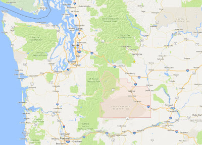
Let me show you.  Here is a plot of the number of days over the last two years that the temperature exceeded 90F.   There is a localized maximum (dark red) near Yakima (a map, with Yakima County indicated, is also shown for reference).


What about average minimum temperature?   Another localized warm maximum around Yakima.   In fact, Yakima has the warmest low temperatures in the state!

A plot of the high temperatures yesterday around the Yakima area, show the Yakima Airport (YKM) is warmer than any place else in the neighborhood (63).


So what is going on at the Yakima Airport?   It is something of a mystery.  The National Weather Service says they checked out the sensor and it seems to be calibrated ok.  The Yakima instrument suite is typical of U.S. airports: NWS/FAA ASOS (Automated Surface Observing System).

Using Google Maps, there is an image of the airport area, with downtown Yakima to the north and east.  The oval shows the location of the Yakima weather instruments.

And here is a blow up of the weather instruments area.  The instruments are in a vegetated area between two runways.


So what is going on?   The airport is relatively low, so that would contribute to daytime warmth, but not at night.  The vegetation is dry, so it would warm up more than irrigated fields, but that doesn't explain the nighttime warmth.  And besides, some of the cooler neighborhood weather instruments are on unirrigated land or in urban areas.  The neighboring runways could warm up during the day and perhaps release heat at night.

The high resolution UW WRF model forecast for 5 PM Monday (below) does not suggest a warm bullseye over the airport--so it does not indicate some strange (but real) local weather feature.


There have been a number of reports (and publications) bringing into question the sensor used in the NWS ASOS stations:  the H0-83 hydro-thermometer (see picture).   These papers (example here) suggest a number of possible problems, including insufficient ventilation of the enclosure (the white object below).


So the origin of the warmth at Yakima is still not clear, but the reported start in 2011 does suggest some instrumentation issue.

Finally, this example explains something many of you have asked in the comments...why are there isolated warm and cool areas on the climatological maps I show (like the average maximum temperature map over the past two years below).  The answer is probably bad sensors or unrepresentative locations (like a sensor near a building or over concrete).  My discipline needs to do better.
_____________________________________

Help Support Regional Climate Research at the UW

Society needs to know the regional impacts of climate change and the UW is building a regional climate modeling effort.  With Federal funding collapsing, we are trying community funding approach.  If you want more information or are interested in helping, please go here.  The full link is: https://uw.useed.net/projects/822/home


March 26, 2017

Peak Snowpack Time

Historically, the snowpack over the Pacific Northwest mountains peaks right about now--the last days of March to first week in April--something that is illustrated by the figure below (a figure from Amar Andalkar's wonderful skiing the Cascade volcanoes site).


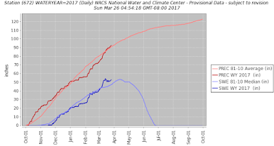
This year the regional mountain snowpack surged in early March, but has stagnated the last week or so because of warmer weather, something illustrated by the snowpack numbers at the Olallie Meadows SNOTEL site near Snoqualmie Pass (dark blue is this year's snow water equvalent, SW), light blue is normal.


Why does our snowpack hit its maximum around April 1, a time when the sun is getting quite strong (equivalent to mid-September)?

Before we talk about that, here are the latest snowpack numbers (percent of normal) around the West.  Virtually all the West is well above normal for SWE (total amount of water in the snowpack), with California's Sierra Nevada being crazy high.

As noted by Mark Albright, past state climatologist, with 720 inches of snowfall through 23 March, Mt Baker Ski Area has recorded its snowiest winter since the big snow years of 2011-12 with 808 inches and 2010-11 with 857 inches.  This is going to be a  long ski season for the Northwest.  Enough snow that Washington DOT is delaying its clearing of North Cascades Highway (SR20);   according to WA DOT it may be the latest opening since 1974.  This WSDOT photo of SR 20 near Liberty Bell mountain shows some of the challenges, including several avalanche chutes.


So why does Cascade snowpack peak around April 1?   It is all about temperature.  Since our weather systems come off the Pacific, it is good to look at the vertical sounding at Qullayute, on the NW WA coast.  Below are the climatologies of temperature there for three levels (925 hPa--around 2500 ft, 850 hPa--around 5000 ft, and 700 hPa--around 10,000 ft).  Those levels pretty much bracket the Northwest high terrain.  You will notice that they have a similar characteristic:   temperatures aloft don't start warming until mid-April.  I talked about that in a previous blog---the atmosphere has a lot of thermal inertia, which means it takes a while for the increasing warming at the surface to influence the deeper atmosphere.   So with temperatures remain cool and precipitation still hitting our region, snow accumulation can continue into early April.


And there is another issue, snow is highly reflective, so a lot of the sun over the mountains is reflected to space rather warm the surface.    This is an issue regarding our regional impacts of global warming.  As the earth warms, our mountain snowpack will lessen, which will allow more solar radiation to be absorbed, which causes more warming and thus melted snow.   A positive feedback for destroying snow and warming our region.

Those effects will become profound later in the century, but so far there have been only minimal losses of Cascade snowpack.     Larry Schick of the US Army Corps of Engineers, also known as the Grand Poobah of NW Powder, sent me some snow statistics of major regional ski areas provided by Tony Crocker (his best snow web site has lots of good material).  Both the Pacific Northwest and California ski areas show little trend (black line) through 2013.


And an analysis of snow water equivalent (SWE) of over 200 SNOTEL sites around the NW through 2016 by Mark Albright suggests little trend over the past 30 years (see below)

Now before some folks get irritated with me, let me underline that this will all change by mid-century as greenhouse gases increases.   We have been "protected" by the slow to warm eastern Pacific. but eventually the radiative effects of increasing greenhouse gases will warm the lower atmosphere even here causing substantially reduce snowpack.

Finally, what about the next week?  The latest ECMWF snow forecast shows some additional snow at higher elevations across our region.  Enjoy.


March 23, 2017

When is the air aloft the coldest and driest on average? Now!

Strange enough that one might think is belongs in some kind of Ripley's Weather Believe or Not.

What part of the year is the air above the Pacific Northwest typically the driest (least amount of water vapor)?

What part of the year is the above the Pacific Northwest typically the coldest?

The answers to these two questions are the same:  right around now!  But why?

Let's start with a measure of the total water vapor in a vertical column (called precipitable water) for Quillayute, WA (UIL), on the NW Washington coast (see below).   The black line is the average and the red line is the extreme high values. Lowest values (driest air)  in late March/early April.  Interestingly, the driest air is not when our precipitation is the least (late July/early August).  The amount of moist is highest during our driest period.  Very strange.

Next, let's go to a specific level (850 hPa--about 5000 ft).  The mixing ratio (the amount of water vapor-in grams- per kilogram of dry air) shows a similar pattern, with driest conditions in early spring.


How do we explain this weird situation?  The answer is found with temperature.

The amount of water vapor that can be held (or contained) in a volume of air depends on temperature, with warm air able to hold more water vapor.  Here is the temperature at 850 hPa (again about 5000 ft).  Ah ha!  It looks like the moisture!   The warmest temperatures aloft are in early August and the coolest average temperatures are in late winter (March).

So in late winter/early spring when the atmosphere aloft is coolest, the moisture content is less since cold air can hold less moisture than warm air.

But that leaves another question.  Why are air temperatures aloft coolest in March? Why aren't the temperatures aloft coolest when the sun is weakest (late December)?   

The reason is that there is substantial thermal inertia of the atmosphere--it takes a while to warm it up.   Like a giant flywheel.   And remember that the atmosphere cools as along as long as the amount of energy leaving the atmosphere (by radiation and other processes) exceeds what is coming in (solar radiation, heat provided by the condensation of water vapor)


The surface of the earth has less thermal inertia and tend to respond more rapidly to heating/cooling at the earth's surface then the atmosphere above.  Thus, the lowest surface air temperatures tend to be in middle to late January in our region, not the spring.

There is an interesting meteorological implication of the different rate of heating between air near the surface and aloft:  the atmosphere over our region tends to be most unstable (tendency to convect) during spring compared to any other time of the year.

The atmosphere becomes less stable when the rate of cooling with height (called the lapse rate) is greatest.  If in late winter or early spring, the ground warms up faster than the air aloft, then the lapse rate becomes larger during that period.   This is particularly true in spring when the sun (and thus heating near the ground) is getting large.

This figure shows the lapse rate in the lowest 10,000 ft above Quilluyate across the year (black is average, red line is extreme max, blue line extreme min).  The lapse rate is largest in April.


Large lapse rates promote instability, which produces cumulus and cumulonimbus clouds, which in turn bring the famous convective rain showers of NW spring.  So spring is a showery period in our region because of the surface warms more quickly than the atmosphere above.


March 21, 2017

A Good Winter for Northwest Potholes: Why?

This has been a big year for Northwest potholes, feared by drivers and bicyclists alike.  And should not be a surprise, considering the weather has been "ideal" for producing potholes:  more cold (sub-freezing) temperatures than the past few years and lots of precipitation.


There has been plenty of media coverage of the pothole epidemic  (see below from KING5 and KIRO)

One well-covered pothole in Spokane took out 8 cars in a few minutes!  In Spokane, the pothole problem became so crippling for cyclists and cars, that anarchists (Portland Anarchist Road Care) started filling them in!  When anarchist are fixing roads instead of tearing stuff down, you know you have a problem.


Now, Seattle is well organized in the pothole business and the city even has a pothole map.  The figure below shows the potholes that have are either pending to be fixed (blue) or repaired during the past 90 days.  Road dangers lurk in much of the city.  Be careful out there.


 So why has this been such a bountiful year for axle-breaking, tire-destroying, potholes in our region?

 Because it has been much colder than the past few years, with lots of sub-freezing weather and loads of precipitation.

Why is subfreezing weather important?   To understand why you need to know how water density (and volume) changes with temperature.   The figure below shows how the volume of a gram of water varies with temperature.  Starting above freezing, as water cools down it reaches maximum density (minimum volume) around 4C, and then the volume increases slowly towards freezing.  But then things get exciting:  the volume increases substantially as water freezes.  To put it another way, water expands substantially as it transitions from liquid water to ice.


Such expansion can produce tremendous force--cracking rocks or bursting pipes.


Water can get below a roadbed, either through small cracks or from the side.  If temperatures drop below freezing, the water can expand, push up upon and breaking the roadway (see schematic below)  When the temperature warms, the ice contracts leaving a void below the roadway, which can result in the road collapsing  due to the weight of cars.  The more times this process is repeated, the more the road can be undermined.

So below-freezing temperatures are helpful to produce potholes, as is plentiful precipitation to supply the water that freezes.  

Let's take a look at temperatures this and previous winters.  At Seattle (see below), lots of surface air temperatures (yellow line) that dropped below the normal lows (blue line) and freezing this winter.  Much more that the previous two years.
At Spokane, it was an amazingly cold year, with several days dropping to 0F or below!
Portland had many days below freezing this winter, producing lots of ice and snow.


The figure below shows that all the urban areas were substantially wetter than normal, supplying lots of water to invade the sub-surface between the roadways

The bottom line of all this.  A wet year with lots of moisture invaded roadway subsurfaces.   With the coldest winter in years, with lots of subfreezing temperatures, there were excellent conditions for the production of tire-bursting potholes in Seattle, Portland and Spokane.

One positive thing:  it could have been worse:


March 20, 2017

Might Bipartisan Actions Revolutionize U.S. Weather Prediction?

 There is now a major opportunity to lay the basis for far better weather prediction in the U.S.  

And the effort could be completely bipartisan.    It would also provide an example of how both sides of the aisle can work together to make major improvements in a key national capability--weather prediction-- saving lives, protecting property, and substantially enhancing the economic vitality of the U.S.

There are two bipartisan bills before Congress right now that are worthy of support:

1. The Weather Research and Forecasting Innovation Act of 2017:  H.R. 353 sponsored by Rep. Frank Lucas (R OK), Suzanne Bonamici (D OR), Lamar Smith ( TX), and others. And its carbon-copy version in the Senate.

2.  Radar Gap Study Act.  Text is here.  Sponsored by Senator Maria Cantwell (D WA),  Senator Richard Burr and Tom Tillis (R NC). Representative Robert Pittenger (R-NC) introduced companion legislation in the House of Representatives.

The Weather Research and Forecasting Innovation Act is extraordinarily forward leaning.  Its goal is to:

To improve the National Oceanic and Atmospheric Administration’s weather research through a focused program of investment on affordable and attainable advances in observational, computing, and modeling capabilities to support substantial improvement in weather forecasting and prediction of high impact weather events, to expand commercial opportunities for the provision of weather data, and for other purposes.

The specifics of the bill are enough to warm the heart of any American concerned about the quality  and future U.S. weather prediction, including:

1.  Organization of a coherent research program for improving U.S. weather science and prediction, including extramural (outside of the U.S. government) research.
2.  Develop rational methods for designing and supporting the U.S. weather observation system (amazingly this had really not been done).
3.  Organized efforts to improve U.S. tornado, hurricane, and subseasonal (less than a few months) forecasting.
4.  Requirement that the US Air Force explain their problematic selection of a non-U.S. weather modeling system for their operational requirements (big mistake by the way)
5.  Calls for the evaluation of more private sector weather observation assets.
6.  Annual reviews of the computer resources available for U.S. weather prediction.

..and much more.  The bill includes the financial resources needed for the above.    


Basically Congress is telling the NOAA/National Weather Service that is expect U.S. should be state-of-the-science and that the time for excuses are over.  Some in NOAA might be discomfited that Congress is providing a lot of guidance about what needs to be done.  But quite frankly, progress has been too slow and it is going to take Congress to move the U.S. weather prediction effort into higher gear.

The radar act sponsored by Senator Cantwell and her Republican colleagues from North Carolina?

It directs the National Weather Service (NWS) to determine which areas of the country have inadequate weather radar and develop a plan to improve radar coverage.  And there are major gaps in the radar coverage such the coastal zone west of Oregon, the eastern slopes of the Cascades, and much of eastern Oregon.  The National Weather Service radar coverage below 4, 6, and 10K feet ABOVE GROUND LEVEL (shown below for country and the NW) shows major gaps in the west, but the situation is MUCH worse than presented here.  Many of the radars start out high and thus the radar beams can miss the critical lower atmosphere. Radar coverage is very much needed along the eastern slopes of the Cascades for wildfire management and localized flash flood prediction.


I think we can be very hopeful that these important legislative measures will have a decent chance of passage.   Weather prediction is important for the entire country irrespective of one's political bent. Red states suffer from hurricanes and severe thunderstorms.  Blue states from atmospheric rivers and coastal storms.  Both endure drought, floods, wildfires, and windstorms.  Both Red and Blue state economies are highly vulnerable to weather for agriculture, transportation and more.

And yes, weather prediction (ranging from hourly to seasonal prediction) is not climate prediction, so it lacks the controversy of decadal to century-long forecast of greenhouse gas impacts.  So the current administration can support it.


Tomorrow's Windstorm in Four Acts

 Each atmospheric "play" is different and according to high-resolution forecast models, I can describe the four "acts" t...