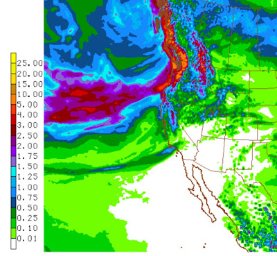
After a very wet February, we have had a soggy March, which accompanied by warmth and snowmelt, is causing some of our rivers to surge. During the past week, much of Washington, NW Oregon, northern Idaho, and Montana have experienced 200-600% of normal precipitation (see below). In contrast, California and the southwest have been dry.
Here are the precipitation totals for the past week from the National Weather Service analysis: 5-10 inches in the coastal mountains (including the Olympics) and the Cascades, with 2-6 inches over the western slopes of the Rockies.
But that is not all. A week ago we had a normal snowpack, with substantial snow at lower elevations east of the Cascade crest. But then the atmospheric circulation shifted so that warmer air flooded the region from the southwest. As an illustration, the observed and typical temperatures for Spokane Airport are shown below. Several recent days surged well above normal.
With lots of rain and substantial snow melt, water has been pouring into local rivers. Here is the latest map from the NOAA/NWS Portland River Forecast Center. Several western WA/Oregon rivers are at bankfull or flood stage, and notice that the Spokane river and some other draining off the Rockies are also at flood stage.
And it is not over yet. Here is the NWS GFS model total precipitation forecast for the next 7 days. Lots of rain over the Northwest (5-10 inches in the mountains).
There are going to be a lot of very happy ducks.


Hey Cliff- I live here in the Skagit County and have noticed that oftentimes there are no flood warnings or watches in here when King, Snohomish or Pierce are under warnings and/or watches. I'd like to read a post of yours investigating this- comparing high rainfall events that impact the counties on the western slope and corresponding "flooding". My hunch is that Skagit County experiences fewer "flood warnings/watches" because there is less development here, whereas increased development in the watersheds of King, Snohomish and Pierce counties causes more frequent flooding. This could be a teaching moment for those in more populated counties who should strive to slow down the runoff of stormwater and protect wetland or floodplain ecosystems.
ReplyDeleteI'm ready to dry out, can you tell us if there is an end to all this rain any time soon?
ReplyDeleteI keep hearing winter is over but we seem to always get a stint of rain and a last blast of winter. What do you think for this year? I'm hoping to another blast of mountain snow.
ReplyDeleteThanks!
@Cliff, explain this one. In Burien right now it's 50F with light snow and light rain?! We are up around 475', but this is BIZARRE!!!
ReplyDeleteI second Snaparella's question! How about a blog on the most likely ETA of some sunshine? Even my turtles are getting tired of this.
ReplyDeleteClimate change signals - whenever I've heard about the great snowpack this year, I wondered: "but will it melt off early?"
ReplyDeleteThere it goes!
I'd like to see the SWE trends over the next few days.
Earthwater -
ReplyDeleteWant to back up your claim with facts that a mid-March rain at lower elevations in the Cascades is a "climate change signal?" Or is even remotely abnormal?
Here is some interesting reading, actually backed up by facts: Cliff Mass Blog, May 25, 2016:
"Mark Albright, past Washington State climatologist, has plotted up the Steven's Pass melt-dates from 1981-2015 (see below). The annual melt-out dates are shown by the blue dots, the mean over the period by the horizontal gray line, and the 5-year running mean by the purple line. There is no evidence of a long-term trend for earlier melt-out dates. In fact, just the opposite....melt out dates are trending later (which implies cooling or greater snowpacks or both)."
If you plot out the Snoqualmie Pass data you will find the same.
I look forward to your analysis backed up by actual facts that refutes this.
http://scrippsscholars.ucsd.edu/content/large-scale-atmospheric-forcing-recent-trends-toward-early-snowmelt-runoff-california
Delete"ince the late 1940s, snowmelt and runoff have come increasingly early in the water year in many basins in northern and central California. "
Interesting challenge.
ReplyDeletehttps://nsidc.org/cryosphere/snow/climate.html
"Climate warming can reduce snowfall, and cause earlier spring melts and shorter snow cover seasons. For instance, warmer air in Alaska has caused the snow to melt earlier each spring, lengthening the snow-free summer season."
https://www.epa.gov/climate-indicators/snow-ice
ReplyDelete"The length of time when snow covers the ground has become shorter by nearly two weeks since 1972, on average."
Count me as not shocked you can find generalized articles that say things like "climate warming can reduce snowfall." Two can play that game. Should I now trot out the studies that said that arctic ice would be completely gone by now?
ReplyDeleteSo again, in the interest of science and specific to your original comment, can you please provide the statistics and data to refute the study done by Albright re: Cascade snowpack and the trend toward later melt-out?
The forecast for the Cascades in the next week is for 1-2 feet of snow. So also, can you please support your "there it goes!" claim regarding current Cascade snowpack?
Thank you.
I'll confess to hyperbole. Checking SWE changes I can see that some sites are melting off and some are not. And it appears that most of the Columbia flows are coming from the Snake River.
ReplyDeleteNonetheless, I am not trying to refute the studies you tout. There are different ways to interpret "signal". One definition is significant observed changes. It may indeed be too soon to spot a shift in spring rains and earlier runoff from existing measurements.
My use of the word "signal" was meant more to mean a pattern consistent with modeled predictions. In that sense, heavy winter and spring rains with early runoff are consistent with modeled predictions of future climate.
Yep, every departure from a mythical average is now held out as proof that the AGW Cult is right!
ReplyDeleteAs an enthusiastic neophyte to this blog my inquiry may have been previously covered. Your recent topics have covered the coldest NW in a generation and now an incredibly wet one. It would seem that some place around the globe is suffering from the dry, hot reverse (Australia perhaps?). Would it be possible to present that or point me to a past blog that shows the effects of our current pattern and the counter result elsewhere? Thanks.
ReplyDelete