And we are going enjoy such a heat wave this week. But why a mid-spring heat wave?
By mid-April, our sun is strong and the days are long....keep in mind that the sun's strength today is the same as August 20th.

But to get the heat we have to turn off our natural air conditioning...onshore flow off the cool Pacific. And to get real warmth, some nice downslope flow down the western slopes of the Cascades, allowing air to warm by compression.
And there is a way to do this...have high pressure build to the east of the Cascades....and that is exactly what will happen this week.
The fact we often get heat waves in April and May is obvious by looking at a climatological plot of extreme daily temperatures at Sea-Tac Airport (yellow line below). Temperatures have zoomed up to 80 in April, 80s (even low 90s) during May.

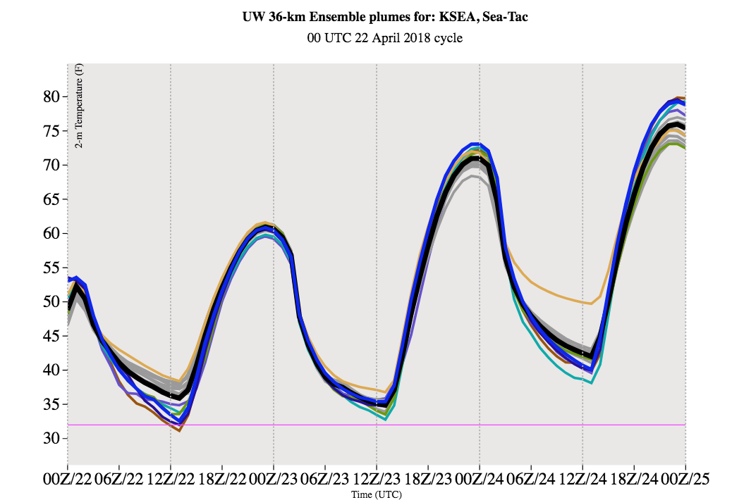
At the UW we run a high-resolution ensemble of 15 forecasts to get a handle on the uncertainties in the forecast. Here is prediction for surface air temperature from last night's run. The black is the ensemble average...normally a very good forecast. Nearly right-on for today (high got to 59F). Tomorrow's model forecast bringa Sea-Tac to 70F...roughly a ten-degree hike. And 75F on Tuesday.
Want more assurance of the warmth? Here is the latest output of the National Weather Service Short-Range Ensemble System (SREF). 70F tomorrow, 75F on Tuesday and a bit warmer on Wednesday, although you will notice that there is increasing uncertainty (the forecasts vary more).

You really want to enjoy the warmth before it happens? Let me show you the surface temperature forecast maps from the UW system.
First, the forecast for 5 PM tomorrow (Monday). 68-72F in much of western Washington. 72-76F around Portland and over the western foothills of the Cascades.

Tuesday at 5 PM. Amazing. Upper 70s from Seattle to Portland. Even along the coast, thanks to the offshore flow.

Wednesday at 5 PM. A bit cooler over Seattle, but much warmer around the Columbia Basin of eastern Washington. This is a sign that the high pressure is moving eastward.

Enjoy the warmth...after a cool, wet few weeks it will be nice to experience the spring-time lushness of the Northwest under sunny skies and perfect temperatures.
There is one problem, though....the pollen count is high right now and according to pollen.com will get higher with all this warmth (see below). Sorry...


More disproof of global warming, http://weatherwest.com/archives/6252
ReplyDeleteThis comment has been removed by the author.
DeleteSurface area of the earth: 196 million square miles.
DeleteArea of California: 163,000 square miles
Area of California as a percentage of all of earth: 0.08%
Likelihood the area of California is a decent sample for "global" anything... very, very small.
Spring heat waves often are enhanced by a cutoff low southwest of here that helps build the high pressure ridge and advects the warm air into our area,as will be the case this year,too.It will be interesting to see if we also get the first batch of warm season thunderstorms as the offshore low ejects inland later this week.
ReplyDeleteDonald Strong, I read the info at the link you posted. How does that peer reviewed research "disprove" global warming?
ReplyDeleteYou mean this is not evidence of AGW like every other remarkable weather event?
ReplyDeleteI personally am SICK of spring heat waves. Why do we have to hit 80 degrees in late April as opposed to late May? Furthermore my phone is actually predicting a DROP in temperature tomorrow before going back up on Thursday. Then I bet we’ll have another one in a week or two like we did in 2014.
ReplyDeleteDo you also hate fun? Good lord, find something worthwhile to complain about.
DeleteI so love the warmth of the sun. Bring in the Beach Boys. Break out the sand, surf and bubbly boo and good and enjoy life in the pouring rain and all. Love the reCAPTCHA, I am not a robot but I am Klingon and I do believe in Aliens.
ReplyDeleteWhy are we so hazy today (Tues). Looks like smoke, seems early for fires.
ReplyDeleteThat entire paper was framed in the assumption of global climate change as a truth. Here is a quote from the above paper,
ReplyDelete“As most of us already know, global climate is presently changing at a rate faster than has occurred in thousands of years, almost exclusively due to the emission of greenhouse gases (like carbon dioxide) into the Earth’s atmosphere”.
Science is a thing, the Earth is round and it’s heating up.