But temperatures have been rapidly warming the past week and the snow is melting fast. You can appreciate the sudden warm up at Pasco in the central Columbia Basin from the figure below. A progressive warming the last few day to highs that are even above normal.

March 13th--the Columbia Basin is snowbound


By March 17th, the holes are really enlarging.
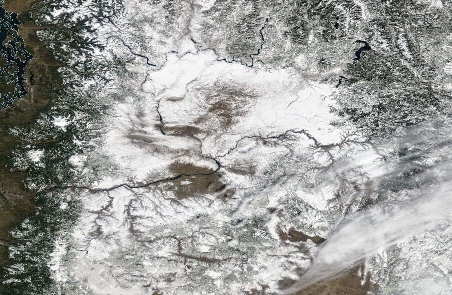
By March 20, broad areas are snow-free.


The National Weather Service is warning about some very minor localized small stream flooding...nothing much to worry about. But the snow cover and cold temperatures have left the soil temperatures quite cold in the Columbia Basin.
Here are the soil temperatures 8 inches below the surface from the WSU Agweather website. Many are above 50F in western WA, much fewer in eastern WA, where some are still in the 30sF. The agricultural season will be slow starting east of the Cascades.


The snowcover is pretty much gone in the areas exposed to sun over here in Spokane.But it's fairly deep,8" plus,in shady areas.Soil temps should warm up fast now that snow has gone.Planted my peas on schedule,thanks to strategic use of black tarps to melt snow and cloches to cover up the plantings.We have to resort to a few tricks over here in the colder parts of the state. ;)
ReplyDeleteWould have been good to ski the Eastern foothills. My broken toe got in the way of X-C skiing...
ReplyDeleteCliff when will the weather workshop be this year? I though it was usually in March, but it seems to vary...
Hey, Mr Mass, .... any chance of seeing the Northern lights tonight? (I'm near Hood Canal Bridge)?
ReplyDeleteBut the upper Columbia basin appears to be in trouble. Washington Dept of Ecology concludes that the Okanogan and Methow watersheds did not get the awesome snowpack like the rest of the state. Water supply shortages are anticipated as a result.
ReplyDeleteThe Olympics did not seem to pick up much snow over winter. The recent warming looks to have dropped rain and accelerated the melt there. Are snow packs currently low already? Are we heading in for a bad fire season?
ReplyDelete