But why?
Before I answer that question, let me get you into the mood by watching an extraordinary video produced by the master of weather cams, Greg Johnson of Skunk Bay weather. He has four cams looking northward from his home on the north side of the Kitsap Peninsula. Stunning amount of lightning was captured by his cams...both cloud to cloud and cloud to ground. Be prepared to be moved....
To get strong thunderstorms, the key requirements are an unstable atmosphere--one that will convect if air parcels are lifted---and something that will push the air parcels upwards until they can rise on their own. And for Saturday night's thunderstorms, we needed something else as well--winds aloft that would direct the thunderstorms away from their generation points in the Cascades and up Puget Sound.
Extraordinary Instability
A column of air is primed for instability when the temperature decreases rapidly with height, and
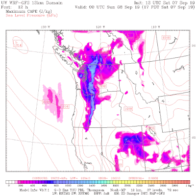
with plenty of moisture in the layer near the surface. A measure of the potential for instability is something called CAPE: Convective Available Potential Energy. The values of CAPE forecast over western Washington for Saturday late afternoon and evening were amazing (see below), with CAPE at 5 PM getting to around 1500 J per kg over the Cascades and 700 over Puget Sound. Around here, we get excited when we get values reaching 100-200. So the values were very high, very unusual, and signified the potential for strong thunderstorms.
with plenty of moisture in the layer near the surface. A measure of the potential for instability is something called CAPE: Convective Available Potential Energy. The values of CAPE forecast over western Washington for Saturday late afternoon and evening were amazing (see below), with CAPE at 5 PM getting to around 1500 J per kg over the Cascades and 700 over Puget Sound. Around here, we get excited when we get values reaching 100-200. So the values were very high, very unusual, and signified the potential for strong thunderstorms.
One reason that values were so high was the blob of warm water off our coast. The BLOB not only contributed to warmth at the surface but more water vapor--important fuel for instability. The eastern Pacific sea surface temperature is roughly 5 F above normal and that implies substantially more moisture in the lower atmosphere. At the same time, an upper level trough was bringing in cooler than normal air above the surface (see map for 500 hPa...roughly 18,000 ft). So warm, humid air at low levels with cold air aloft. That means a large change of temperature with height and lots of potential instability.
But as in the late night commercials, WAIT...there's even more! The approaching upper level trough was associated with upward motion, which help trigger the convection (thunderstorms). Initially, the focus of the storms were over the Cascades, because the mountains provide more lift and an elevated heat source.
But because the trough was negatively tilted--oriented northwest-southeast--the flow aloft had a southeasterly aspect to it (flow from southeast), which helped the thunderstorms born over the southern Cascades to move over the western lowlands. This southeasterly flow was evident in the winds above SeaTac Airport as shown below (see blue oval indicates the relevant elevation and time). The heights are in pressure, with 700 about 10,000 ft. Time is on the x-axis, with 08/03 being 8 PM and time increasing to the right.
So we had the trifecta for Puget Sound thunderstorms: great instability, a sharp trough aloft given strong lift, and the perfect winds to drift the storms over the lowlands.
To have the combination of all three is quite rare around here. As noted in my earlier blogs, the large instability produced some of the tallest, strongest and most numerous thunderstorms we have seen here in a very long time. Some tops got to 40,000 ft.
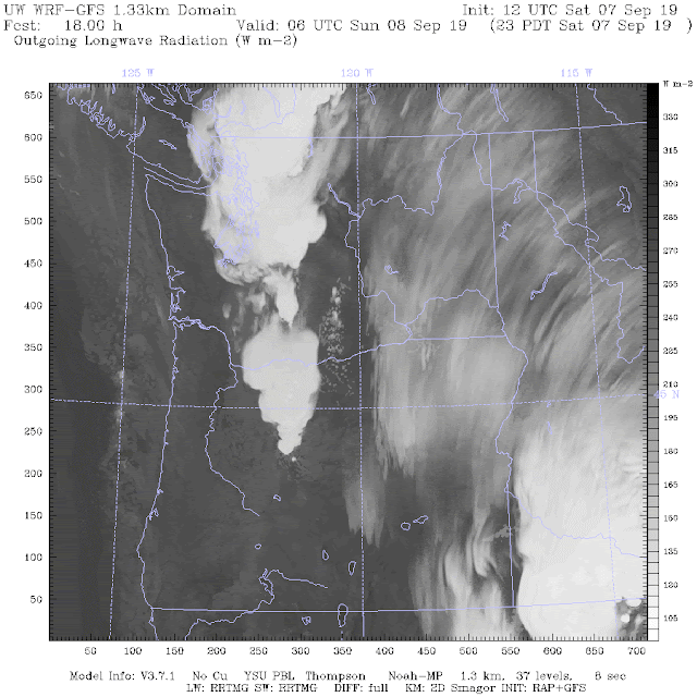
The ultra-high resolution UW WRF model did an amazingly good job on the forecast. Here is the simulated infrared 18-h forecast from the highest resolution domain. It was going for big convective cells over western Washington. Impressive.


Great explanation and Greg's video with music gets me every time.
ReplyDeleteWell, rats! I was in Port Townsend and we got NOTHING! Just a little rain Sunday afternoon but no thunder and lightning at all. I am told my home area in Mill creek got lots. Always seems to happen when I'm away...
ReplyDeleteWell Ansel,
DeleteYou know wood is not a good conductor, it was all those boats at the Wooden Boat Festival, put the electricity right off its stroke and "bounced"it over to Whidbey... Now if you had been around a bunch of steel fishing boats...well
Here's hoping for a rerun tonight, per some of the forecasts...
ReplyDeleteJust had a porch umbrella take flight. Landed upside down on the roof. Any other reports of such a thing? Happened bout 12:30 pm Monday the 9th in lake forest park.
ReplyDeleteI looked at the CAPE on ventusky.net today. I'm curious to know what is a "big number" vs. a "normal number". If I understand correctly, anything above zero is potentially unstable, but the higher the number, the more likely we are to have a big thunderstorm.
ReplyDeleteI come from Ohio, last foothill of the Appalachians, so I remember those anvil clouds marching in from the west.
From the atmosphere's point of view, those are the *first* foothills of the Appalachians. You said it yourself: "from the west."
Delete;)
Love it love it love it!!!
ReplyDeleteYou can't just look at any CAPE product, most of them are calculated from the surface (SBCAPE) which would have showed zero on Saturday. The instability was elevated (above the marine layer). The UW WRF product is "most unstable" CAPE (MUCAPE) which finds the most unstable layer in the lower atmosphere--more useful for the elevated storms that we get around here. Also explains why the storms did not care if there was low-level stratus or not.
ReplyDeleteDefinitely the biggest event I can recall since we had a similar set up in August 1999. That event started in the mid-afternoon with 2 to 3 bouts of lightning and thunder. I don't recall it being as rainy though. July 1984 is still the uncontested champ for lightning storms though. Many of you have likely seen a photo from that storm, the famous shot of a huge lightning bolt stretching across downtown Seattle from the Space Needle to the Columbia Center. The thunder from that bolt was so severe it shook our North Seattle house! I'd love to compare the data from that storm to what we just experienced. :)
ReplyDeleteI'm also curious if this was the worst case scenario for a thunderstorm.
Cliff, my recollection of the last event of comparable magnitude was the August 3, 1999 event, when the poor guy sitting on a bench in the HUB lawn got struck, or nearly struck, and sent to the hospital. That would actually be 25 years! Or was there something more recent that I'm not recalling?
ReplyDelete