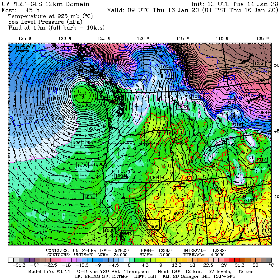
The feature of interest is a trough offshore (area of low pressure, indicated by the white oval) in a forecast of sea level pressure (black lines) for 4 PM today. The colors are low-level temperatures, with blue and purple showing air cold enough to snow.

The latest infrared satellite image shows the feature. Not very impressive-- would not call my mother about it.

For example, the latest NOAA/NWS high-resolution rapid refresh modeling system (HRRR), brings the leading edge of the snow into the Olympic Peninsula by 7 PM.


The latest UW model forecast for snow accumulation through 7 AM Wednesday is a bit different, with 2-5 inches from Seattle northward and huge amounts of snow in the Olympics.
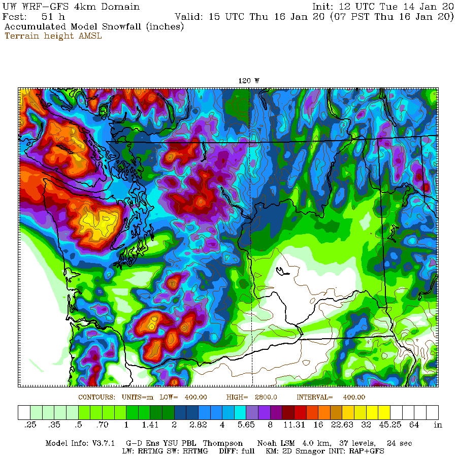
The vaunted European Center model is similar to the UW prediction, with less snow over the southern Sound.

The bottom line: a good chance of significant snow from Seattle northward, with up to 3-5 inches, particular from north Seattle to Everett.
At this point, it appears that tonight will be the big snow event for the rest of the week, with the situation less favorable on Wed-Thursday as a powerful low center (and warmer air) moves up the coast (see sea level pressure map for 1 AM Thursday. Snow will have a greater tendency to stick to the roads after a few days of cool temperatures.


We're getting lots of snowfall in Carnation right now. Been dumping snow since 1130 this morning!
ReplyDeleteI'm in the 'Nation too. Just off Tolt Hill Road. It's a sheet of ice, last I heard there was a moving truck(!) stuck between where I am and 202. Why anyone would even TRY to bring a moving truck down THR in the snow is beyond me, but there it was...
DeleteIs that deep low on Thu going to be a wind-maker?
ReplyDeleteomg, THANK GOD YOU'RE BACK.
ReplyDeleteThanks for the post Cliff. I've booked a hotel near where I work in Bothell to negate a Seattle commute.
ReplyDeleteDahlia we just got through an hour of flurries in Bothell I suspect the horrible stuff ( commuting bias ) may soon ease in Carnation.
Light snow all day here above Hood Canal at 500 ft. By the looks of things, this next storm system will give this area a lot of snow quickly.
ReplyDeleteCurrently 28 degrees with 6" on the ground.
That little white dot in the snow map near kent, that is suppose to get 0 snow...that's about where I live. All the past week it's like there's an invisible weather bubble around us. The snow from north comes down, but not quite to us. The snow from the south comes north, but not quite too us. Really frustrating for someone who loves this weather!
ReplyDeleteMainly it seems the Olympics are great at keeping us dry here. Although at the moment it's pretty wind, seemingly from the south or SE.
Here is the long-awaited weather report - as of 12:46 pm - from the internationally acclaimed BOW WA weather reporting rock-on-a-string. White, cold.
ReplyDeleteWas there a model that accurately predicted the 10+ inches in Poulsbo area or 5” on Bainbridge Island this past event?
ReplyDeleteIt's NEVER a good idea to call Mother about this kind of thing, and probably a good idea not to call Mother unless it's necessary.
ReplyDeleteSo Cliff - what happened to the much ballyhoed coldest air in years>
ReplyDeleteI heard it didn't get here (which is very likely why you never saw it).
DeleteIt's all up here in whatcom county, currently 12°
DeleteYep, this is day three of wind chill temps at or below zero in north Whatcom County.
DeleteAaaaand the sun is shining in Tacoma... and has been since this morning.
ReplyDeleteYou have the best job!
ReplyDeleteThanks cliff!!!
ReplyDeleteSteady snow in Sammamish since this morning. Accumulation is no less than February last year, several inches. Seems like forecasters underestimated.
ReplyDeleteIt's snowing in North Seattle and has been (on/off) for much of the day. Thanks for the update and info about tonight's potential event.
ReplyDeleteLots of big white fluffy flakes in downtown Bellevue! Gorgeous.
ReplyDeleteAnd just barely started snowing here in Maple Valley!
ReplyDeleteI hope you are able to do a wrap-up after this several day cold event is over. I feel like it was well-forecasted on a a large scale, but the details were a complete mess.
ReplyDeleteSo do we trust your forecasts even though they’ve been significantly and consistently off the mark? You stated in an earlier post that we’d see roughly 2-4 inches in some places, and it wasn’t going to be too bad, but as I write I’m seeing a blizzard dumping snow on an already 14” base...
ReplyDeleteYou know what they say, meteorology is the only career where you can be wrong half the time and still have a job.
Where are you? Because my area has just had a dusting
DeleteThe way this country going, that can be said about most careers today.
DeleteI measured a morning low temp of 14.4F in NW Bellingham today. This is the coldest temperature I've recorded since measurements began 10/1/15!
ReplyDeleteCliff, I monitor weather all over on WINDY.COM and noticed there are 4 "competing" and sometimes strikingly different forecasts. GFS, ECMWF, METEOBLUE, and NAM. For example, I just noticed at midnight tonight, GFS says winds in Clinton will be about 7 mph, but ECMWF says 22 mph ! Why the huge difference? GFS says 9PM tonight 29 degrees but ECMWF says 35. NAM seems to follow ECMWF and METEOBLUE closer to GFS. Which is more accurate? Is it a regional thing?
ReplyDeleteThis is certainly a lot more snow in Seattle than the initial ~1" estimates you were posting for the Sun/Mon timeline.
ReplyDeleteHere in Monroe it has been snowing on and off (mostly on) for most of the day. The snow has been slow but steady, leaving a scant 1/2-1” since I got to work @6 this morning. There’s something about the combination of this bitter cold, frozen side streets, and the current forecast that has got people nervous about coming to town. I work at a restaurant and usually snow brings patrons. But today was the slowest snow day that I’ve ever seen in my 14 years working downtown. It doesn’t help that the pass is closed so we have seen zero tourists and out of towners. Is anybody else already over this weather? lol
ReplyDeleteHow about winds tomorrow, particularly in the Sammamish/Issaquah area?
ReplyDeleteHow about the winds on Weds night? I'm most concerned about a double whammy of snow and power outages.
ReplyDeleteFederal way is sunny with no snow- looks like we’ll miss it again - my kids are pretty bummed
ReplyDeleteFederal way is sunny with no snow now - kids are pretty bummed
ReplyDeleteThe event is for later. Read what the man says.
DeleteI wish it was like this from November 1 to May 1 every year, but colder than it is currently. There might not be anything in the world I love more than snow.
ReplyDeleteNo snow near North Lynnwood today after around 5" on Sunday evening. Just noticed that the storm watch for today was changed to a storm warning. Hoping for more snow since it should melt next week with the warm front.
ReplyDeleteFor those concerned about winds, NWS has issued a high wind watch already. But this is an easterly threat, mostly in the Cascade foothills. If you want timely weather forecasts from a large group of weather forecasters, NWS should be your first stop.
ReplyDeletehttps://www.wrh.noaa.gov/FXC/wxstory.php?wfo=sew
https://forecast.weather.gov/showsigwx.php?warnzone=WAZ503&warncounty=WAC073&firewxzone=WAZ653&local_place1=Bellingham%20WA&product1=High+Wind+Watch&lat=48.75&lon=-122.48#.Xh5UeiOIblg
About 3 inches on the ground in S. Bellingham at 6:30 pm and light/moderate snowfall.
ReplyDeleteLooking at the radar, I think the winter storm warning of 1-3 inches will be woefully inaccurate when this thing is over!
Cliff,
ReplyDeleteThanks for investing your time and energy on keeping us informed!
just started lightly snowing 8:55 pm in east bellevue. hoping for some more!
ReplyDeleteAnd I quote, “The bottom line: a good chance of significant snow from Seattle northward, with up to 3-5 inches, particular from north Seattle to Everett.”
ReplyDelete...I’m in that area and have zero new snow as of 1am. Nice forecast!!
A good chance isn't ap guarantee. These weather events are basically impossible to accurately forecast so throwing Cliff under the bus isn't helpful.
DeleteYou know what else isn’t helpful? Blogging about things that are “impossible to accurately forecast”.
DeleteHere’s a forecast for everyone: there’s a chance of clouds today. And the high will be around 45.
Boom. I’m a weatherman! Now you can’t hold me responsible if it’s clear blue skies and 60, because I said “chance”.
...what a crock.
It's been snowing almost continuously in Glacier since Saturday, but until this evening the snow was very light (at times, nearly all needles, plates, and the like) because it's been so cold
ReplyDeleteTonight (Monday), snowfall has intensified.
I just wanted to thank Cliff for this blog. Where else would we get a detailed glimpse into the science behind forecasting?
ReplyDeleteI would estimate that we received about 4" to 6" of snow at our place near the Bellingham Airport last night. It appeared to stop around 3 am. The rate of snow was fairly low most of the time, but it lasted for around 8 hours.
ReplyDelete35 degrees in Port Townsend as of 6:30 this morning, and what little snow we had gotten over the past couple of days (1 inch or less) is all but gone. A couple of very disappointed kids this morning to see this! Wind is picking up already from the South.
ReplyDeleteCliff, I don't envy your job at all trying to read the tea leaves when events like this come up. It would be very interesting to learn about what made these forecasts go sideways - I'm thinking mainly about the bitter cold that was essentially a no-show, but also the wild variations in precipitation. For example, Port Angeles is less than 50 miles from Port Townsend as the crow flies, and they woke up to 18" plus of snow this morning, while we got bubkus! How are these types of events used to refine models? Thanks for all you do!
Reporting from the great white north...
ReplyDeleteAfter a lovely XC ski this morning, I can report that S. Bellingham has anywhere between 5 and 8 inches on the ground.
It's also very cold!
10" above Hood Canal, heavy bands of snow last night and forcast covered it perfect.....just 31 degrees now and occasional flakes falling.
ReplyDeleteReady for the next round in a few hours.
I live in Redmond. I am disappointed that this storm seems to have mostly missed the immediate Seattle metro area; understood that the worst of it was to have gone north, but was hoping for at least an inch or two out of it to freshen the snowcover. Not an inch, not a dusting, absolutely nothing. But I completely understand it was an especially difficult forecast. We still have another 4-6 weeks where accumulating lowland snow is a reasonable possibility. I love snowmageddon situations.
ReplyDeleteOne of the more uncommon temperature events occurred last night in Bellingham:
ReplyDelete10:53 pm: 27F
11:53 pm: 45F
12:53 am: 43F
01:53 am: 43F
02:53 am: 41F
03:53 am: 26F
By this morning it was back to 22F. During the temperature rise, there were strong southerly winds. When I when to bed, I thought we were in the big melt off, only to find out this morning that the melt turned to ice and we were back to northerly winds.
Thank you, Cliff to you and all the weather forecasters at NWS. I know it was a bust for many locations around Western WA Tuesday night, but it was an absolute life saver to have the heads up for the potential of a major snow. I took note of NWS and your blogs forecast in making preparations as I work for the City of Port Angeles on the Power line crew. It turned out to be more than we expected, but living here I have come to expect that. We had a true 18 to 30 inches from the straight to the west hills of PA. I was out all night in it patrolling line and have never seen anything of the likes in my adult life. Our work truck was pushing snow up to its headlights...it was incredible. I know you get flack from some people that dont understand the weather phenomenon that exist here and how weather predictions are not a perfect science- that day would be boring anyway... I just wanted to say a Big THANKS Cliff. And of course, keep up the good work!
ReplyDelete