The other coast had no radar coverage, allowing a tornado to strike without warning.
Yesterday (Tuesday), very unstable air mass with strong convection (thunderstorms) made landfall on the Northwest coastline.
The visible satellite image from the NASA MODIS satellite around noon showed lines of strong convection approaching the Oregon/Washington coast (see below)
Why so active? Cold air was moving over water water, which created a large temperature change with height that in turn produces substantial instability--the tendency of the atmosphere to convect.

Roughly an hour before this satellite image, a funnel cloud was observed off of Manzanita, Oregon (on the northern coast) and around 11:15 AM it made landfall as a tornado, causing minor damage. No tornado warning was provided. This was a weak tornado: an EF-0 with winds gusting to 65-75 mph.

One reason there was little warning, is that there is very limited no low-level radar coverage over the Oregon coast, something made obvious by the weather radar map at around 11:15 AM Tuesday.

The Washington State coastal zone is well covered by the Langley Hill radar near Hoquiam, but there is no National Weather Service radar on the Oregon coast.
In contrast, around 5 PM yesterday, the National Weather Service in Seattle provided a tornado warning for the area around Hoquiam and Aberdeen, based on the the Langley Hill radar.
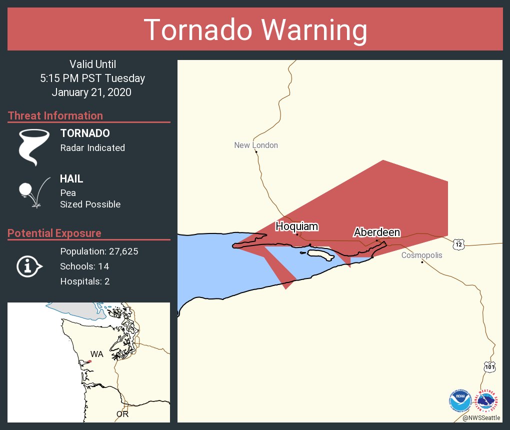
Why did they distribute this warning? Because the Langley Hill radar picked a collection of intense thunderstorm cells (see below) and some of the some of the cells possessed some rotation--something known as a mesocyclone.

At this point, there are no reports of a tornado--but the potential was there.
Interestingly, Manzanita, on the northern Oregon coast, seems to be a tornado hotbed, with another funnel hitting the town in 2016. Sounds like my kind of place for a beach vacation!

More seriously, it is outrageous that the Oregon coast has virtually no radar coverage. Such coverage would not only help protect coastal residents, but would give a heads up for approaching storms for the densely populated Willamette Valley and Puget Sound regions.


Tornados are serious! I hope there is a plan in place to get proper coverage of the Oregon coast.
ReplyDeleteCliff means 2016 with the EF-2 fall storm. I recall some NWS Portland staff reporting on it 3 years ago at Cliff's Northwest Weather Workshop in 2017.
ReplyDeleteMark Nelsens weather blog in Portland addresses this same issue. The Oregon coast needs weather radar.
ReplyDeleteThere are only two things I miss from our departure from the gray of Seattle for the sunshine of central Oregon two years ago: steak at Jak's in Issaquah, and weather forecasts beyond a regurgitation of climatological averages.
ReplyDeleteBend is the second largest metro area in Oregon, and growing like crazy. Microclimates are easily as varied as the Puget Sound, maybe moreso. Yet hundreds of thousands of square miles gets broadbrushed every day with the same forecast. Meteorologists in Pendleton simply don't have the tools necessary to keep up with forecasts required here in 2020.
In reality, we need two more radars - one on the ocean to see what's coming, and one in the vast central Oregon high desert (hint: get the farmers involved - they live and die based on the weather!). The latter would not be blocked by the Cascades and cover the currently "blacked out" region from Bend to the edge of Boise's radar.
Still, I wouldn't trade it back - it's mostly sunny here this morning, again :-) even though the forecast says 92% cloud cover (sigh).
How many square miles do you think Oregon covers?
DeleteCliff is it true, what I suspect- in winter, thunderstorms are actually more common off the coast than over the land?
ReplyDeleteIn a related question to my first, with the SW winter winds, is it true what I heard, that in the NW, the sea is actually warmer in winter? Or does the greater insolation is summer just balance out the up-welling from the northeast wind? Seems counter-intuitive.
ReplyDeleteI have noticed lack of radar off the coast for years. Why is that?
ReplyDeleteThis comment has been removed by a blog administrator.
ReplyDelete