Update at 3PM Thursday
________________________________________
My podcast on this snow event is now available:
Act 1. Thursday afternoon to Friday morning.
We have cold air over us now, cold enough for snow. We just need moisture. Tomorrow, a weak low center will move eastward toward the Oregon coast and this system will be associated with light precipitation (see pressure forecast map for 6 PM Thursday). Too far south to be optimal for Puget Sound snow.


The first act, like all good first acts, is a teaser for the main action after the intermission.
Act 2: Friday evening through Saturday afternoon
Another system...a strong system... will be approaching. And this one will approach at the optimal position near the Columbia River bars. Close enough to spread lots of moisture into Washington State, while it draws cool air into western Washington (see below).

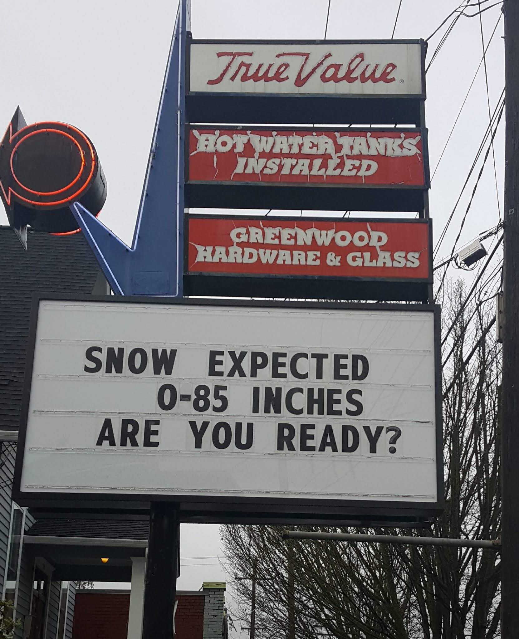
The total snowfall through 4PM Saturday is--how do I say it?---chilling. Total snowfall (NOT SNOWDEPTH) of around a foot in Seattle. Twenty inches over the south Sound and nearly a foot around Bellingham and the San Juans. Four feet in the Cascades. And don't forget eastern Washington, where the southern half could see a foot and nearly two feet in NE Oregon.

Third Act. Sunday and Monday.
A strong front, with warmer temperatures will approach on Monday, with a relatively deep low to the northwest. This will bring snow, followed by a transition to rain. I will talk about that in a future blog.

Can you trust these forecasts? Well, we need to examine the multi-forecast ensemble predictions, each sightly different in how they are started and in the physics we use.
The European Center ensemble snow predictions for Seattle, with each color strip indicating the cumulative snow from one of the 51 forecast runs. They pretty much all show the same story....some light stuff on Thursday, followed by Snowmaggedon on Friday/Saturday (purple color). Folks...this indicates the EC system is very confident about the forecast.

What about the smaller and somewhat inferior U.S. ensemble system forecasts for Seattle snow?
Similar story...but with lighter amounts on Thursday with heavy amounts on Friday/Saturday.

A heavy snow event looks like it is in the cards for Washington State and pretty much all the state will be effected. Let's say that outside dining may not be optimal this weekend.
I will be doing a podcast that I will put online around 3 PM. Just click the link at the upper left of this blog or download the podcast from your favorite repository.


Dr. Mass,
ReplyDeleteAre these ECMWF forecasts available to the general public? I think I found the site but its a little overwhelming to navigate and I think what I also found is that the forecasts may be behind a paywall for research and commercial interests.
The default model for the superb Windy.com is the ECMWF, and you can select others to compare. Lots of options in there to play around with. Consider supporting them if you love it :)
DeleteTropical Tidbits
DeleteThis is a question of mine, too. It appears the detailed European forecasts are mainly available by commercial subscription.
DeleteI found a weather forum recently where the PNW members are having a blast watching this forecast evolve. Some of them know where to get a wide variety of forecasts - I think I've seen half a dozen different models posted, updated ever 6 hours. That has really highlighted for me how much variation there is between different forecasts when looking more than 3 days out, especially for Pacific NW snow.
That raises another curiosity in my mind, because when I look at the forecast maps they label as GFS, they don't match the GFS forecasts that UW publishes. Maybe they were cherry picking the snowiest ensemble members though.
Pivotal Weather has lots of free stuff. Click "models" link at top of home page. Lots of models! This blog gives me more useful information, though, by turning that "blizzard" of info into cohesive weather forecast. pivotalweather.com
Deletewww.windy.com has the ECMWF. https://weather.cod.edu/forecast/ has plenty of models too.
DeleteNot sure if I can recommend websites but Meteoblue offers some great data for a reasonable price. You get all the major weather models in one view and make your own decisions from there. Much needed in my line of business!!
DeleteWow I think we may actually get a good old fashion snow storm this time..what is the chance the 1st snow storm drifts north by 50 miles
ReplyDeleteProbably quite low. Looks like all the models are fairly lined up for Thursday/Friday.
DeletePer your distinction between snow fall and snow depth - it seems like this event would have a relatively strong equivalence, since we are starting with cold temps and dry ground. Is that a reasonable assumption, or well other factors increase the delta, such as dry air?
ReplyDeleteThank you for the info! Love your blogs
ReplyDeleteNice
ReplyDeleteCan't wait!
ReplyDeleteCliff - Any guess as to what time heavier (sticking to roads) snow might start on Friday?
ReplyDeleteHow much depth does a foot of snowfall equate to?
ReplyDeleteThanks for keeping us on top of this Cliff! Speaking of outdoor dining, I wonder if the "shelters" that have been constructed will hold up to all this snow? I sure hope restaurant owners are planning for snow removal from the roofs, and/or closing outdoor dining until it's safe again!
ReplyDeleteNot all heroes wear capes...Dr. Mass you are the unsung hero of the PNW! Hope you enjoy the 0-85 inches of snow ;)
ReplyDeleteI say, Bring it!!!
ReplyDeleteLet's see what you got mother nature!!
Thanks for this. It is so much better than the TV weather. Seems like they were reluctant to use the Euro model until it agreed with the US. Is this Weather Service bias?
ReplyDeleteNeither models do very well with predicting snow events in the Puget Sound region, to be honest.
DeleteThanks for the warning! News forecasts I've seen aren't warning about the potential extent of the Friday/Saturday event.
ReplyDeleteIt is interesting that local tv weather is still not reporting on this possibility- they still are downplaying it as possible snow with maybe some light accumulations- even sarturday.
ReplyDeletePlausible deniability. Most Television meteorologists air on that side because of past "snow event" volatility.
DeleteI guess that they err while on air!
DeleteA similar thing happened in New York city a couple years ago, NOAA's inferior forecasting model didn't show much snow and they ignored many other models that showed substantial snow. More often than not snowfall forecasts bust so they are more comfortable with the low end model. This storm is less likely to bust because so many models show big accumulations and they should at least say there is a chance of a big storm so people can do a supply run before the roads get icy tomorrow afternoon. This is really terrible reporting on their part witholding critical information can be as bad as lying. I don't watch any TV news stations they are too biased, I get my news online.
DeleteEven in the late night news last night, the two local channels we watch here in Seattle were showing maybe 3" for Seattle by the time it is all said and done. It is interesting how far off they can be from these other major models! I give KOMO credit, though- they did show the Euro and American models that Cliff talked about here, and showed that forecast of about 12-13 inches for all of the Seattle metro area by Sunday night.
DeleteMy heart is aching for those who live outside (human and animal). A foot or more in one day is a lot, and this year, they can't shelter inside because of the virus. So sad.
ReplyDeleteI was out today. It was such a lovely day that I kept having to tell myself we're days away from snowmaggedon.
Thanks to you, I think I'm starting to understand how certain weather patterns work. My take is that the snow will be worse on Saturday because the temperature is about to go up, so it's the change that unsettles the skies.
As I've said before, I study your blog and podcast so that I have a deeper understanding of what it means to live in this magnificent state.
Thank you. Stay safe, be well and take care.
Oh for pete's sake. OF COURSE they can shelter inside because of the virus. Like 99.5 percent of the rest of the population.
DeleteNWS forecasts have not really picked up on this and are calling for a few inches in north Seattle thru the weekend with "50% chance of snow" on Saturday. I wonder what model they are using?? They are forecasting a substantial snow south of Seattle Thursday/Friday. Ah, but they are catching on-- there's now some bulletins about possible snow event with "high uncertainty" on Saturday. The mystery-- what will happen? If Seattle gets dumped on Saturday-- Cliff certainly gave a warning several days in advance. If that's what's going to happen, the NWS might not really incorporate into the forecasts until Thursday or Friday. Are they erring on the side of caution?
ReplyDeleteLove the 0-85" forecast. Perfect!
ReplyDeleteThanks! And Thanks for the share Cliff
DeleteRepeating again so people understand...
ReplyDeleteSnowfall does not equate to Snow DEPTH. We may get a LOT of snowfall, but minimal accumulation on the ground due to various factors.
Cliff nws seattle is saying 4 to 6 inches for seattle for Saturday's storm why the difference between what you are saying and them?.
ReplyDeleteThe ECMWF ensemble plots are from WeatherBell, which costs $25 a month. (I'm a subscriber). As far as I know, ECMWF plots are not free anywhere. GFS (US) plots are free in many places, including NOAA.
ReplyDeleteCliff, I had to share... my wife just ran into my home office and exclaimed "You've got to listen to Cliff Mass' latest recording! Now that's a man that can get me excited!" It may be cold outside, but thanks for getting things warmed up inside my home. Happy Valentines Day Everyone. Ha!
ReplyDeleteLooks like a good hood canal snow event. Its been flurries on and off since 2 pm, nothing much but its cold enough at 35 for snow.
ReplyDeleteBy Thursday night I'm expecting accumulations here.
hopefully SDOT and King County Metro will be ready.
ReplyDeleteCliff, Dr Mass - what about icing? I think that is the big threat if we get it. Remember when all streets near U were a single sheet of ice all the way down to the water?
ReplyDeleteHad wild convo today with Covid vaccine scheduler at major medical provider - shall not name them. I asked about their snow plan, regarding my appointment at their large clinic this Saturday in Renton. Of course they didn't have a plan yet. She was anxiously awaiting guidance from her administration. And listed off a dozen major problems a sudden dump of snow will create. Just shows the ripple effect of all this uncertainty. Yet NOAA forecast not showing weather warnings for Seattle.
ReplyDeleteThanks so much for your wise words. You were spot on with the Olympic peninsula snowmaggenden’s in the past. Any thoughts on how it will present in Port Angeles/sequim/Forks this time?
ReplyDeleteThe NAM model(North American Mesoscale Model) is going with about 2 ft over Seattle. What are the chances of that?
ReplyDeleteIs there any forecast for N. Seattle, Shoreline, or Snohomish co? I check them on NOAA but they aren't agreeing with this.
ReplyDeleteWhats it looking like for Bellingham? Seems like a pretty good drop off as we go north.
ReplyDeleteI feel like I'm living in two different worlds. In Cliff's world, I am terrified of trying to find the right window to go over the pass/sad to not be able to just stay home and enjoy this. In the NOAA/Weather Underground/Snow Forecast world, it looks like a decent snowstorm - 6 inches in the lowlands and similar amounts of snow in the mountains. If I didn't read Mass, I would have no idea this was even a possibility. It's bizarre.
ReplyDeleteHow about an update showing the UW mm5 00z snow forecast?
ReplyDeleteThis stuff of snow in Seattle is like reading the Seattle Times every year of the hype on how good the Mariners are. I will believe it, when I see it.
ReplyDeleteLook heres the deal: it's gonna snoe.
ReplyDeleteMight wanna check the models again. Cause it was showing upwards of 7 inches in seattle yesterday. No showing barely 2. And now no snow at all untill after 5pm friday. I don't quite understand how it changes so drastically in a matter of hours but it literally seems to every single time.. I'm starting to wonder if this is all just gunna fizzle out....
ReplyDeleteWell it was fun while the excitement lasted I guess.
DeleteLiving in the puget sound area for my entire life, I've learned to only believe forecasts that are about 6 hours out when it comes to wind/snow.
DeleteAnd why, when the forecast changes, does it always seem to change to less snow? I wonder if this is an artifact of the changing climate patterns? Are models getting worse at predicting as the historical behavior they are based on is less representative of what happens now?
DeleteThis comment has been removed by the author.
ReplyDeleteYes, its a bit early yet but this seems like a classic busted forecast for the Seattle Metro. Micro climates might yield some snow here and there. Areas from Olympia south will be shoveling but by Monday Seattle will once again be questioning why all the hype was over nothing.
ReplyDeleteHopefully Cliff has an update this afternoon. Be fun to see a decent snow, but there are reasons why Seattle is the size it is compared to Portland. HINT: Business interests do not like interesting weather.
Both the GFS and ECMWF appear to be pulling back on snow totals everywhere - now 4" Seattle and 3" Bellingham.
ReplyDeleteThe most likely chance of serious snow for the folks up north (Whatcom) will be the warm system on Sunday night. That situation can easily dump 6" if the fraser outflow keeps going.
Looking at the satellite loop, the current storm looks to be heading towards N CA, which is several hundred miles south of the model forecasts.
ReplyDeleteCliff - does that increase the chances of the Friday night system also heading further south and just giving us a glancing blow instead of a direct hit?
yeah right. this is the guy who 'predicted' a huge storm a couple years ago and it was a bunch of nothing
ReplyDeleteHas been snowing all morning here in Olympia. Ground zero! Starting to stick to pavement now, and have a couple inches on grass. So there, all you skeptics! Anyway, a forecast gives a range of possibilities. Doesn't guarantee any particular outcome. That has been one of the main points of this blog for the past couple days. You know, all those difference colored bars on the ensemble forecasts, etc, etc. Try to understand the science, please!
ReplyDelete