April 30, 2021

How Far Into The Future Can We Predict the Weather? My New Podcast Discusses That and the Weekend Forecast.

 I am often asked about how far into the future weather prediction is possible 

My podcast (link below) reveals the answer and also provides a relatively optimistic weekend forecast.

And don't forget the Northwest Weather Workshop tomorrow morning!  

Three hours of local weather and climate talks, with time for questions. And it will end with a spectacular video by Greg Johnson of Skunk Bay Weather.  More information below.  Please register if you want to attend.  It will be completely online.

Finally, for rainshadow fans, check out the visible satellite image this morning.  You see the clearing northeast of the Olympics?  A good example of the Olympic rainshadow.


Compare the cams at Seqium and Seattle below--both take at the same time.  A classic.


Here is my podcast:

Click the play button to listen or use your favorite streaming service (see below)

You can stream my podcast from your favorite services:


_______________
Announcement

The Northwest Weather Workshop, the annual gathering to talk about Northwest weather, climate, and major meteorological events, will take place on May 1, 2021. This year we will have a special session on the meteorology of the September 2020 regional wildfires. The meeting will be online. More information, the agenda, and registration information is found here: https://atmos.uw.edu/pnww/

April 29, 2021

Extremely Dry Conditions Hit the Pacific Nothwest

Portland will probably achieve a record in a few days:  the driest April ever observed, with much of the rest of the region also sharing below-normal rainfall.  

What is causing this dryness?   Have we been trending towards drier April conditions over the region?   What is the precipitation outlook for the next month?   

All of these issues will be discussed in this blog.

But first Portland.  

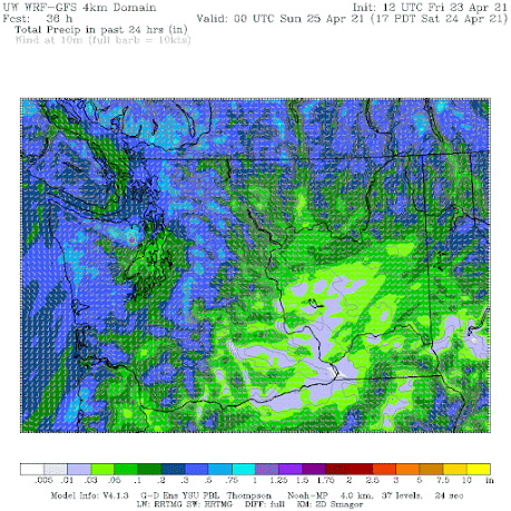
The driest April on record was in 1956 when just 0.53 inches fell over the entire month.  With two days left to go, Portland's monthly total is 0.29 inches.  The latest precipitation forecast through 4 AM Saturday (below) shows only a few hundredths of precipitation falling on Portland.  

The record will probably be broken.


The past month has been drier than normal over our region.  The figures below the departure from normal over the past 30 days for precipitation over both Oregon and Washington.  Both western Oregon and Washington have been substantially drier than normal, with some locations by as much as 4-6 inches below average (western slopes of the Cascades and the Olympics).   


The reason for this dryness (as well as dry conditions over California)?  
 The persistent ridging (high pressure) over the eastern Pacific and roughing (low pressure) over the central U.S.   

This is illustrated by a chart showing the difference from normal (the anomaly) of 500 hPa heights (think of this as the pressure at around 18,000 ft) for the past month.  The red area indicates much higher than normal pressure over the eastern Pacific.  This pattern tends to cut off the moist southwesterly flow that brings substantial rain to our region. Instead we have relatively dry northwesterly to northerly flow.

Why did this pattern set up?   Although there could be other causes, this pattern is consistent with La Nina (cool waters in the central/eastern tropical Pacific), which has been in place during the past winter.  March was also quite dry over the West Coast, for the same reason.

A natural question is whether Aprils are getting drier, and, if so, whether global warming could be contributing.   So let's plot up April precipitation over Washington and Oregon from 1930 through 2019, using the NOAA/NWS Climate Division data.  

Interestingly, the trend is towards wetter Aprils.  So there is little reason to point to climate change as the cause of our current dry conditions.


Looking forward to the Spring season, what can we expect for precipitation?  Although our forecast skill does fade substantially for projections more than a week, let me show you the latest one-month precipitation forecast from the most skillful extended prediction system on the planet--from the European Center for Medium-Range Weather Forecasting.

Oh-oh. More of the same. Drier than normal over the Northwest and California.


For us here in the Northwest, we probably have no worries about water supply this summer.  The snowpack is above normal still over most of Washington, and the western slops of the Oregon Cascades are only modestly below normal (see graphic).  But eastern Oregon has seriously reduced snowpack.

The reservoirs that supply western Washington and Portland are in good shape and the critical Yakima River Reservoirs are near normal (see below): snowmelt should fill them.


But the dry conditions are of concern, particularly regarding an earlier than normal wildfire season east of the Cascade crest.  The 10-h deal fuel moisture (applicable to grasses and shrubs) is now dry enough to burn in portions of eastern Oregon and California, and probably as well over sections of the lower eastern slopes of the Cascades.  

We will need to be careful.


______________
Announcement

The Northwest Weather Workshop, the annual gathering to talk about Northwest weather, climate, and major meteorological events, will take place on May 1, 2021. This year we will have a special session on the meteorology of the September 2020 regional wildfires. The meeting will be online. More information, the agenda, and registration information is found here: https://atmos.uw.edu/pnww/


April 27, 2021

Regional Sea Breezes and Clouds

______________
Announcement

The Northwest Weather Workshop, the annual gathering to talk about Northwest weather, climate, and major meteorological events, will take place on May 1, 2021. This year we will have a special session on the meteorology of the September 2020 regional wildfires. The meeting will be online. More information, the agenda, and registration information is found here: https://atmos.uw.edu/pnww/

__________________________


The visible satellite imagery yesterday was intriguing, with the development of interesting cloud-free zones, driven by local sea breezes, land-water contrasts, and slope winds.

Let me show you.

At 9:16 AM (1616 UTC) there were lots of low clouds from the Cascade crest westward.


By 11:51 AM, the heating by the strong late-April sun was having an impact, with the development of instability clouds.....cumulus clouds... over land.  But not over water, which does not change temperature much during the day.   Note the development of clouds over some of the ridges in eastern Washington.


The satellite image at 2:16 PM shows profound clearing in the Straits of Juan de Fuca and Georgia, clearing near Puget Sound, and clearing along the coast. Why?


And the situation at 4:51 PM goes further, with the coastal clear zone over the Strait moving inland, with the clearing extending eastward of Whidbey Island.   

It all makes total sense, as I will now explain.


Along the coast, a fairly strong sea breeze developed, with heating over the land causing an in rush of cool, marine air at low levels (see schematic).  The low-level cool air cut off the instability that creates the cumulus clouds, which require a large change of temperature with height to form (warm surface, cool atmosphere aloft).   

Furthermore, the sinking air behind the sea breeze over water kills off clouds.  Notice how clear the coast zone became!


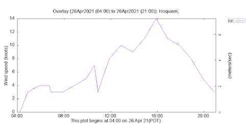
If you want to see proof of the sea breeze, here are yesterday's wind speeds and direction at Hoquiam--located on the central WA coast.  Winds increased during the day to 14 knots and switched from easterly (from the east) in the early morning to westerly by noon.  Classic sea breeze.


The Strait of Juan de Fuca cleared for two reasons.  First, there was an influx of cool air during the day from the west, as a REGIONAL sea breeze developed between the heated western Washington interior and the cooler coast.  Cool air suppresses cumulus development as noted above.  

But there is more.  There is upslope on the terrain surrounding the Strait of Juan de Fuca, which results in sinking air over the Strait (see schematic).  And sinking air is bad for clouds.

Clouds cleared over Puget Sound and the Strait of Georgia for similar reasons.  And the cloud clearing east of Whidbey Island was associated with cool air pushing eastward through the Strait during the day.

What about the clouds developing on the ridges in eastern Washington (see blow-up below).  That is due to heating on the slopes causing upslope flow on both sides of the terrain features, resulting in strong upward motion and clouds near the crest (see schematic)


The bottom line is that many of the details of our local clouds during the warm season can be explained by local wind circulations forced by solar heating at the surface.


April 25, 2021

The Most Boring April Day on Record?

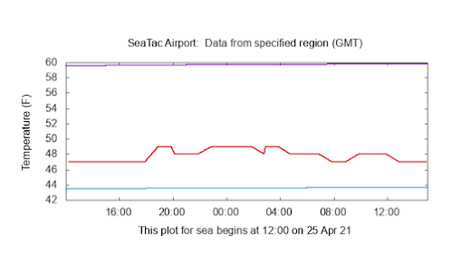
The temperature yesterday in Seattle was extraordinarily flat-lined, varying by only a degree or two over 24 hours. 

If the weather was a patient, we would be getting out the defibrillator paddles to shock the meteorological heart back into action.

To show you this remarkable absence of temperature variation, here is a plot of surface air temperature at Seattle Tacoma Airport over the past two weeks.  Most days had a healthy diurnal (daily) range of temperatures, with some (April 17-21) with as much as 40F between the daily minimum and maximum.  April is generally a month with big temperature swings since the sun is quite strong (similar to August). 

But look at the last day (through 8 AM this morning).....very little change at all.

The temperature plot for the 27 hours ending at 8 AM this morning is stunning, ranging from 47 to 49F.  

Looking at the past several years, I could find no April day so boringly dull.

Why so dull?  

Blame continuous cloud cover and steady light rain.  Hour after hour of benighted drizzle.

The visible satellite image at noon PDT yesterday shows the story, with a dense cloud cover over the region.


As a result, the amount of solar radiation coming in was VERY low, as illustrated by the solar radiation plot at Seattle for the past two weeks from WSU's AgweatherNet.

Like one-third of the peak of the others days of the period.  You did not have to worry about getting a sunburn yesterday.


But there was a silver lining to the drizzly cool day:  pollen levels plummeted to low levels, providing relief to allergy suffers.

Sensitive folks had been complaining to me recently, since the warm period we just went through really ramped up pollen levels in the air (see pollen level plot for the past month from pollen.com).

Since April 11th, pollen levels were high (red), but decline yesterday to low to medium.


But allergy suffers should not put away their meds, the improvement is only temporary.   The latest model runs suggest a modest upper-level ridge will rebuild over the east eastern Pacific by Wednesday (see below), which will warm us up and ensure no precipitation for days.


And the National Weather Service GEFS ensemble forecast for surface air temperature at Seattle, which makes use of multiple forecasts, each a bit different, indicates steadily increasing temperatures this week, reaching around 70 F on Thursday, followed by a rapid cool off (and wettening) for next weekend (sorry).

At least no frost to threaten any tomato plants you might have put outside!
______________
Announcement

The Northwest Weather Workshop, the annual gathering to talk about Northwest weather, climate, and major meteorological events, will take place on May 1, 2021. This year we will have a special session on the meteorology of the September 2020 regional wildfires. The meeting will be online. More information, the agenda, and registration information is found here: https://atmos.uw.edu/pnww/

April 23, 2021

New Podcast: The Big Weather Change over the Weekend and the Inside Story on Weather Radar

 Weather radar is an extraordinary technology that both saves lives and helps keep us dry.  In my podcast, I will tell you about how weather radar works and describe its origins during World War II.  Interestingly, it was the obscuration of German bombers by heavy rain that suggested the potential for weather radar (see the image of the British Chain Home radar network below).

British Chain Home radars at Dover

In my podcast, I explain how weather radar works and suggest a smartphone app that can change your life...... at least keep you dry.

The first part of my podcast will deal with the big weather change over the weekend, with Saturday being particularly cool and wet.  The precpitation forecasts for the 24-h amounts ending at 5 PM Saturday suggest that hiking in the mountains might be better planned for another day:


Here is my podcast:

Click the play button to listen or use your favorite streaming service (see below)

You can stream my podcast from your favorite services:


_______________
Announcement

The Northwest Weather Workshop, the annual gathering to talk about Northwest weather, climate, and major meteorological events, will take place on May 1, 2021. This year we will have a special session on the meteorology of the September 2020 regional wildfires. The meeting will be online. More information, the agenda, and registration information is found here: https://atmos.uw.edu/pnww/

April 22, 2021

The Weather Switch is About to be Flipped: Wet and Cool Ahead

 The last week has been magnificent, with warmth and sunshine more reminiscent of mid-July than mid-April.   And it was a godsend for the battle against COVID, since it encouraged people to get out into fresh air (where transmission is nearly zero) and to open their windows during the day.

While we were basking in the warmth, the eastern two-thirds of the nation has been hit by well below normal temperatures and even some snow.  To appreciate the contrasts, here are the temperature differences from normal for the week ending April 20th.   Stunningly cold in the central U.S,  and today it was even snowing in upstate New York.

It is easy to explain the contacts between the warm West Coast and cold interior.   The upper-level pressure pattern was such that there was a major ridge of high pressure over the West Coast and a trough of low pressure over the central U.S. (see upper-level map for 11 PM on Tuesday).   Red indicates above-normal heights/pressures and blue below-normal.


This pattern is about to reverse, as illustrated by the same upper-level map but for 5 PM Sunday. Trough of low pressure/heights over the West Coast/

Rain will move into our region on Saturday morning, with the 24-h totals ending 5 PM Saturday being quite respectable (see forecast map below).   


During the next 24 h (through 5 PM Sunday), lighter showers will continue over the Northwest while the heavier precipitation heads to parched California.


And if you put your sweaters away, you better get them out:  Saturday will only get to around 50F.  Cold enough for snow to return to the Cascades in force, with several inches above 4000 ft (see snow totals through 5 PM Sunday below).


And more rain will fall over us during the next week.  Enjoy the change.


April 20, 2021

The Best April Weather Stretch in Seattle History

If you felt that the weather during the past week in our region has been the best you have ever experienced during mid-spring, with blue skies and perfect temperatures, you are not wrong.

In fact, we broke a new April record at Seattle Tacoma Airport:  the longest run of days reaching 70F or higher during April.  

Yesterday we tied the record, with five days in a row at and above the 70F mark.  Today at 3 PM, we beat the record, with Sea-Tac Airport reaching 70 F.  And we may do it again tomorrow.


The graph of observed Seattle temperatures versus normal highs (purple) and lows (cyan) are shown below, with 70F highlighted with the blue dashed line. We went from cooler than normal before April 12th to the extraordinarily warm period of the past six days, with highs roughly 20F about normal for this time of the year.  July temperatures in April.  And no precipitation for the past week as well.

The regional picture is similar.  For the past week (actually April 12-18th) temperatures have been warmer than normal over the entire state and particularly along the coast (9-15F above normal), where easterly winds kept the cool ocean air at bay.


And the state was drier than normal during the past week, particularly along the western slopes of the Cascades and Olympics, with downslope flow associated with easterly winds and high pressure aloft being primary causes.

If you are a gardener like me you watch the soil temperatures, thinking about putting in those tomatoes or warmer season seeds.   Well, there is good news on that front, with a large increase in soil temperatures (8 inches down) in Seattle (see below)  from roughly 50 to 57F


Temperatures also zoomed up in eastern Washington, as illustrated from the situation at Moses Lake, where soil went from about 51 to 60F.

Tomorrow will be very nice but I have some ill news to tell you.  It won't last.  Clouds and rain are in our future, with a cool, wet weekend ahead.


The Highest Pressure in Ten Years

 Did you feel the pressure yesterday?    Feel a bit weighted down?    If so, it may not be due to the political energy in the air. Yesterday...