One of the most interesting aspects of warm-season weather of our region is the northwest winds that descend the eastern slopes of the Cascades during the summer.
During the mid to late afternoon, the northwesterly winds (from the northwest) tend to increase, peaking during the evening and weakening during the early morning hours. Sometimes the winds can gust to 30-40 mph, so this zephyr can be a significant blow.
Impressively, these downslope winds can push well into the Columbia Basin, often reaching the Tri-Cities.

Picture by minniemouseaunt
Such evening winds are important for many reasons.

Wind direction? From the northwest!
- They provide substantial and reliable power for the wind turbines that have been positioned over and downwind of the eastern slopes of the Cascades.
- Such winds can really rev up wildfires over the eastern Cascades slopes and provide a substantial danger to the community and firefighters. There is a good reason that many eastside fires make major runs during the evening!
This important local weather feature was first described by Doran and Zhang (1994) and I also looked at it, with co-authors, in a few studies. And this phenomenon has been in action during the past several days, as I will show you now.
Let's begin by viewing the winds at Ellensburg, just to the east of the Cascade slopes, during the past three days. Each day, the winds would increase to 20-30 knots during the late afternoon and early evening, followed by a decline around midnight.


High-resolution weather prediction models can simulate and forecast this feature quite well.
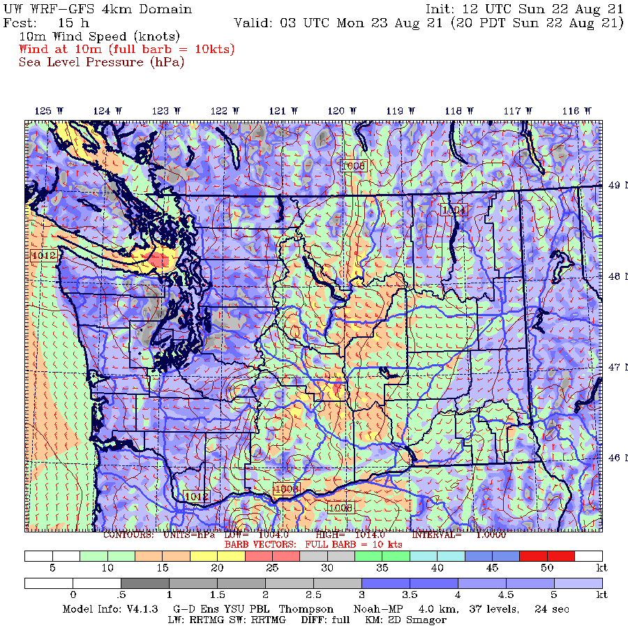
To demonstrate, below is a surface wind speed forecast from the UW model, with yellow, orange, and red indicating the strongest winds. The first image is at 8 AM Sunday and the second is for 8 PM that day.
Can you see the difference between the images? Much stronger winds east of the Cascade crest in the later image. You can also see increasing winds in the eastern Strait of Juan De Fuca!

It is all about pressure.
During the summer, the typical large-scale pressure pattern is to have high pressure over the eastern Pacific and lower pressure over the heated interior away from the coast, something that is shown below (a sea-level pressure map at 5 PM Sunday, the colors are temperature, red and brown are warm).

But as in late-night TV commercials, there is more! During the day, as the interior, less affected by the cool coastal waters, heats up, the pressure falls substantially (warm air is less dense than cool air). Thus we end up with lesser low-level pressure east of the Cascade in the afternoon and early evening. This is something illustrated by the pressures at Pasco over the last three days (see below). Look closely and you can see substantial pressure falls during the day as temperatures warm.

In contrast, atmospheric pressure west of the Cascade crest, where temperatures changes are muted, varies far less, except for the last day as higher pressure built over the region (see below).

So during the day, as temperatures rose much more in eastern Washington, pressures fell there more than in the west, producing an enhanced east-west pressure difference, with lower pressure to the east.
This increasing pressure difference drives westerly/northwesterly winds east of the Cascades crest. It also contributes to increasing westerly flow in the Strait of Juan de Fuca, something that was evident above.


Living in Anacortes near the Strait of Juan de Fuca and Rosario Strait I am very familiar with the on shore flow. The temperature gradient can be 10 deg. F or more in four miles. With on shore often comes dense fog along the west side of Whidbey and north up Rosario to Cypress Island.
ReplyDeleteThe thing that puzzles me is why the Seattle NWS office completely ignores fog in the marine forecast. Recently there was a statement like, "haze from smoke may impair visibility at times". Since they never mention fog I have to assume they don't consider fog an impairment to visibility.
Is fog hard to predict? Why would they never mention fog in the marine forecast? Totally baffling to me.
Maybe it's because fog is so pervasive, at least in susceptible locations, meaning near the water?
ReplyDeleteSort of like including in the forecast: "There will be air tomorrow and plenty of it, along with periods of daylight".
Maybe it's because fog is so pervasive, at least in susceptible locations, meaning near the water?
ReplyDeleteSort of like including in the forecast: "There will be air tomorrow and plenty of it, along with periods of daylight".
During summer a few years ago I saw a camper blown over on I-90 just east of Ellensburg below the hills burgeoning with new wind mills. Beyond newfound appreciation for the power of those winds on a clear day, I learned how dramatically plywood structures can explode and splinter.
ReplyDeleteProfessor Mass, thank you for the thorough explanation.
ReplyDeleteI'm a former accountant, now a chaplain. Your detailed descriptions and accompanying graphics allow me to better understand and appreciate our beautiful environment and unique weather patterns.
Thank you for the lessons.
Very cool info… So that’s why all those turbines spin so nicely along I-90… Thank you.
ReplyDeleteCyclists are very familiar with this! Descending west or east from one of the passes on the late afternoon is a very different experience!
ReplyDelete