We are now experiencing one of the most active weather periods in a while.
It started with several feet of snow in the Cascades and its eastern slopes, which closed all cross-Cascade passes and dumped record snows from Ellensburg to Wenatchee (where the ALL-TIME record 24-h snow record--about 2 feet-- was broken). The regional snowpack is now way above normal.
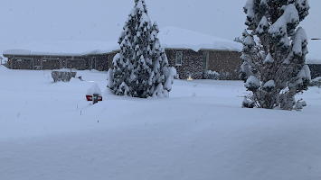
Near Wenatchee Thursday Afternoon Courtesy fo Tom Callahan
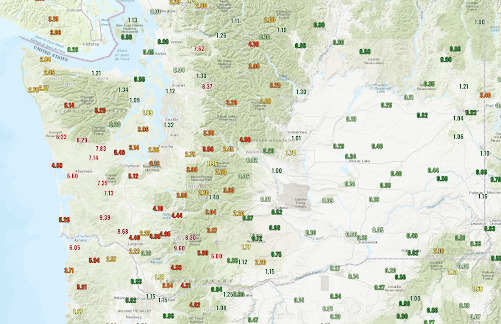
Precipitation? HUGE amounts (see below, click to expand) of up to ten inches over southwest Washington that caused river flooding, particularly for the Chehalis.
And this event ends today with a very strong cold front, behind which a damaging surge of strong westerly winds will move down the Strait, followed by strong winds descending the eastern slopes of the Cascades.
All followed by a calm, dry weekend as high pressure builds aloft.
I will talk about all of this in my podcast, as well as describe the controls of varying types of precipitation: from rain to snow to freezing rain to sleet.
You can listen to the podcast below or through your favorite podcast server.
Some major podcast servers:
Like the podcast? Support on Patreon


It's odd to see the map of rain totals missing a huge amount of area around seattle, bellevue, kent, maple valley, sammamish, puyallup, renton, woodinville, etc. Why are we missing data from the areas with the highest population?
ReplyDeleteFor example, here in east auburn we got over 3 inches of rain from that storm, but if you looked at the map you'd see the closest gauge (seattle) shows only 1.32 inches.
It's a completely misrepresentation of the actual rainfall for the area.
When weather comes in from the SW there's rain shadowing from the Olypic Mountains. If you paid close enough attention to NW weather you'd know that.
DeleteI'm 100% sure you completely misunderstood my comment above.
DeleteI'm talking about rain reports. There are none from the areas I mentioned, even though they represent some of the most populated areas of western washington.
I'm not talking about rain shadows, I'm talking about literal lack of reporting. I live in east auburn, as I mentioned before, we received over 3 inches of rain, but the map shows nothing for my area (i.e. not report at all).
The wettest day in my lifetime yesterday, with 4.82". Took the record by 0.06" but both are an inch higher than my 3rd-wettest. Clearly I've lived in the PNW and nowhere near the tropics. We're 1.8" above normal for January now, based on new 91-2020 PRISM data.
ReplyDeleteI could have missed it, but the Chehalis valley floods seemed to be upwards a stage more serious than earlier predictions. Anybody seen commentary on this?
ReplyDeleteWe live east of Lake Wenatchee at ~2k' elevation and we accumulated 5 feet of snow in a 36 hour period from this system. Two weeks later we are still digging our home's windows, siding, and repairing roof/chimney damage. If would be helpful to hear from cliff what factors combined to create this record event.
ReplyDelete