After one dismal weekend after another, relatively dry conditions are ahead--thanks to persistent ridging--high pressure--over the northeast Pacific.
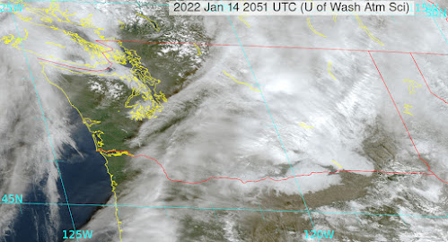
The visible satellite image around noon shows sun reaching the surface for much of western WA, with the exception of fogged in areas near the water. Lots of fog and middle clouds still over eastern WA.

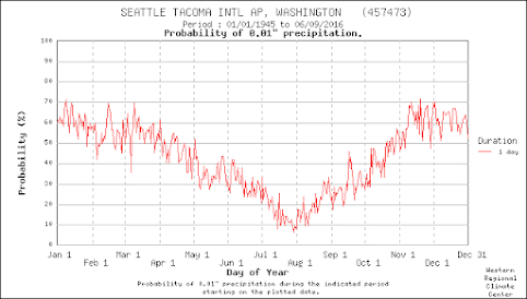
Check the podcast for more details on the forecast....and an explanation of the typical mid-January drying of the region--illustrated by the probability of measurable precipitation at Sea Tac below.
You can listen to the podcast below or through your favorite podcast server.
Some major podcast servers:
Like the podcast? Support on Patreon


I'm seeing a lot of low-to mid 50's in the next ten days. Are you sure these are seasonal?
ReplyDeleteWhat's your sources? The Weather Channel shows temps at best 40-41F for the next 10 days at least, about normal for this area.
DeleteIn my experience 30 years + in Seattle, it is. Although it seemed like it used to be February, too
DeleteThis comment has been removed by the author.
ReplyDeleteWORST weekend in a long time in eastern WA. Inversion weather. Dark and dreary under fog and low stratus deck. Air stagnation. Temps steady at near freezing. Perfect for generating Seasonal Affective Disorder (SAD). I'd prefer howling wind and snow...
ReplyDeleteCan't find a better place to post this.
ReplyDeleteI noticed a significant spike in the barometric pressure graph from my wx station at 4 am PST this morning (Saturday 1-15-22). I started checking stations all up and down the pacific coast on wuground.com. The same spike appears on nearly all of them. Washington, Oregon, California, Mexico but the time is quite different in Chile. I am sure it was the shock wave from the eruption. It is interesting to note that some of the stations show a spike in rainfall and/or a spike in wind speed at nearly the same time.
Really crummy weekend weather here as well. Unrelenting fog, bad air with the inversion. These "breaks" in the rain are really unpleasant and cold. Our January precipitation surplus will be gone soon and we will soon be in a deficit.
ReplyDelete