Winter has not finished with us. Another shot of snow is heading for the mountains. And some lucky folks in the lowlands may see some snowflakes!
Another cold Arctic Blast is coming our way on Sunday.
As discussed in earlier blogs, there has been a major ridge of high pressure over the eastern Pacific (see upper-level 500 hPa pressure/height map for about 18,000 ft ASL at 1 PM today, below).
Such ridges are quite frequent during La Nina years like this one. Troughs of lower pressure can move southward down the eastern flanks of such ridges....and you can see one over southern California right now. It is raining now around LA.
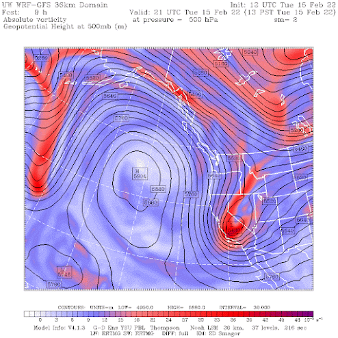
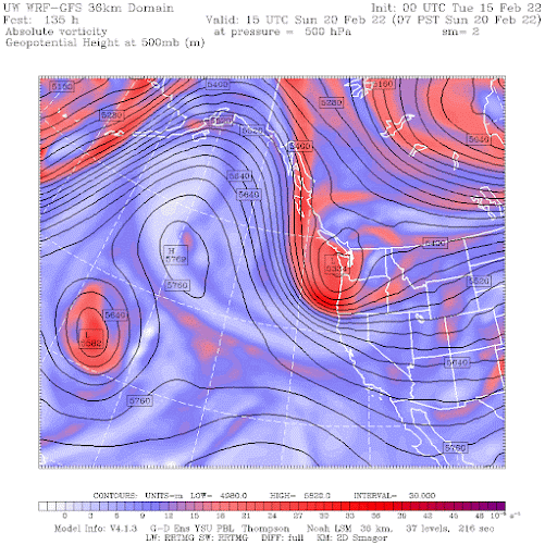
But on Sunday morning, another trough will move around the high...a strong trough...and one that will be in the right position to draw cold air into the region....with the most frigid stuff east of the Cascade crest (see image below)
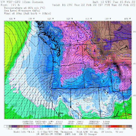
To prepare you for the chill, here is the sea level pressure map (solid lines) and low-level temperatures (colors) for Tuesday at 7 AM.
VERY cold air will move southward east of the Rockies (brown and dark purple colors) and eastern Washington will get modified Arctic air (purple). But even western Oregon and Washington will get a piece of the cold action (blue colors). Cold enough to snow anywhere over the region by Monday. But we will not have much precipitation by that time.
But the trough will bring precipitation and snow to the mountains on Sunday...little doubt about that.
We are still far enough out for the forecast to shift a bit, but colder air and some wintry weather will arrive on Sunday and Monday.
And did I mention the winds?
Skiers will be happy with the snow, but Monday will bring fairly extreme wind chills over the Cascade crest. So be prepared if you go up there.
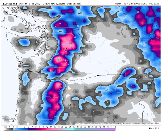
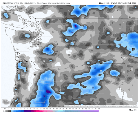
Here is the snow total forecast by the European Center model for the 24-h ending 4 PM Sunday. Over a foot in the Cascades and some flurries over the lowlands away from the water. Skiers will be smiling.
For the next 24-h, the snow will follow the trough southward (see 24-h snowfall amounts ending 4 PM Monday). Light snow in eastern WA, but more will fall over the Oregon Cascades and eastern Oregon.
We are still far enough out for the forecast to shift a bit, but colder air and some wintry weather will arrive on Sunday and Monday.
And did I mention the winds?
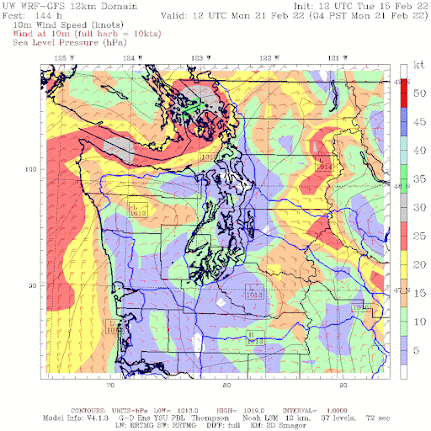
Strong, frigid, northeasterly flow will push out of the Fraser River valley, across Whatcom County, over the San Juans, and then out the Strait (see the wind forecast below
4 AM Monday). You got to feel sorry for those Whatcom country folks...they have really experienced a lot of weather. Strong easterly flow will build over the Cascade crest as well.
Skiers will be happy with the snow, but Monday will bring fairly extreme wind chills over the Cascade crest. So be prepared if you go up there.
It will be nice to have some active weather again after the boring last few weeks.


Cliff, I really hope that the weather workshop will be in-person this year...
ReplyDeleteFalse spring or not, I do know that many of my trees are budding and some of my daffodils look almost ready to open.
ReplyDeleteThe GFS Tuesday morning forecast suggests the temperature at my location may get below 20 degrees briefly before warming up.
This happened last year and killed a nice maple tree growing in my front lawn.
This year I have a bunch of young cedars I planted to restore native vegetation along a seasonally dry wetland that was previously overrun by blackberries. They still look distressed from the heatwave last year. I hope they survive the arrival of meteorological spring.
That last comment is a bit weird, though, since this cold blast validates exactly what they were talking about with the "false Spring". It felt like Spring for a while, but we're getting hit with wintery weather again. It was a false Spring.
ReplyDeleteLove your blog, but sometimes it seems like you let your anti-media biases get ahead of your thoughts a bit.
I feel like the who concept of false Spring is eluding you. Like Booger (LOL) says above, this weather pattern is exactly why people call it false Spring. Happens every single year, Facebook constantly feeds me on this day memories where I'm commenting on Spring-like weather, to be followed by pictures of three foot deep snow drifts in Ferndale a few weeks later.
ReplyDeleteIt is called transitional weather.
DeleteWe can't have spring in the Northwest until we see the daffy's sprouting out from under snow.
ReplyDeleteand how cold is cold? You can't give us a range?
ReplyDeleteEver heard of weather.com? Try that.
DeleteBut, but, but...what about the record warm temperatures we just experienced? Isn't this cold outbreak just another affirmation of AGW, or...errr, I mean...Climate Change? Yeah, we'll now call it Climate Change!
ReplyDeleteCliff, some models are showing the ridge to strengthen again and shift eastward again leaving us high and dry again before the end of the month. What's the deal with "Ridge-Nina?"this year. Its 2001 all over again. The last few weeks have been horrendous for skiers and powder hounds Larry Shick would not approve.
ReplyDeleteWhat is your take on the latest: https://www.wsj.com/articles/scientists-forecast-u-s-sea-levels-could-rise-a-foot-by-2050-11644950063?mod=Searchresults_pos5&page=1
ReplyDelete