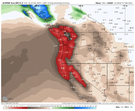
The last few weeks have been much drier than normal in the Northwest....and the reason is clear. A very persistent ridge located along the West Coast or just offshore.
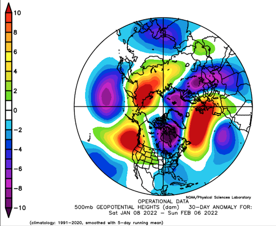
This image below shows the difference (over the past month) from normal of the heights of the 500 hPa pressure surface --you can think of this as the difference of the pressure at 18,000 ft from normal for the last 30 days. The dark red indicates pressures were MUCH higher than normal off our coast. In weather vernacular, there was a major ridge offshore.
On the eastern side of ridges there is generally sinking air and dry conditions. That is where we have been.
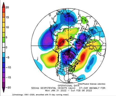
The last week? Essentially the same pattern (see below). One thing you will immediately notice is the wave-like nature of the atmosphere. There is a ridge of high pressure offshore, but a trough over the central US, and a ridge over the West Coast. This is called an amplified wave pattern.
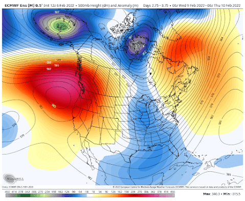
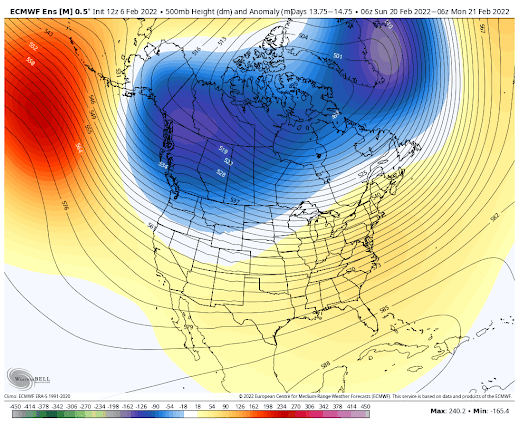
What about the future? Let's look at the best of the best! The European Center ensemble predictions (many forecasts averaged). All the images are from weatherbell.com, a really wonderful service that you can subscribe to. They show the upper atmosphere heights (solid lines) and difference from normal (red to pink are much about normal)
A weak trough moves through on Monday, but by Tuesday evening a big ridge develops offshore. And yes, a strong trough over the Midwest.
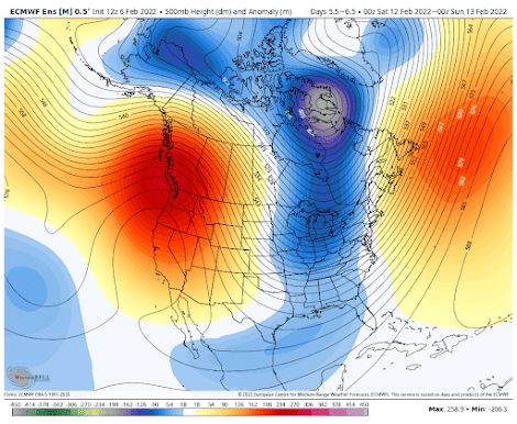

But it would be cruel of me to leave all of you forlorn of hope. A number of long-range forecasts have suggested the potential for a regime change, with a cold, trough developing over the Northwest. Here is the predicted upper-level flow on Sunday February 20th. Blue indicates lower than normal pressure/heights.


Maybe this February will be similar to the one in 1962,which had a warm first half,then a cold second half which culminated in a 7 inch snowstorm on the 28th.
ReplyDeleteOn the other hand,if the offshore ridge builds inland instead if retrograding,we could be talking about the first 60 degree plus temps of the year.And of course,the "Blob" discussions will resurrect again!
As always, I'm grateful for your explanations. Silly nitpicking, but the ides of February is on the 13th.
ReplyDeleteI see we're up for generally clear weather for the next week, but not too warm. I call this the February respite.
ReplyDeleteSince I moved out to the Seattle area in 1968 I've noticed that in quite a few years the second or third week of February brings a period of clear weather, almost springlike, with temperatures sometimes into the 60's. Well it looks like we get the clear and dry part this year, but not the warmth.
Even last year, the snowpack had a massive February, bracketed by 3 weeks of significantly reduced precipitation. Cliff, what is your opinion on the emerging consensus about climate change and its affect on the weakening jet stream and the associated "extremes" being observed?
ReplyDeleteI think Arctic Amplification,meaning an Arctic warming significantly faster than the lower latitudes,is having the effect of a wavier, slower jet stream. We're experiencing this in the form of more persistent and extreme weather patterns. It all makes sense when one asks themselves why the jet stream exists in the first place. Good to see more people talking about this. We always hear that abrupt manmade climate change is causing more extreme weather, but we seldom get an explanation of how or why.
DeleteCliff,wondering if you could explain the difference between this high pressure event and the one of a week or two ago. That one created fog and low clouds and a strong inversion on both sides of the Cascades, that doesn't seem to be the case this time around. At least not on the west side of the mountains. Can we expect fog and low clouds in the Kittitas Valley and Columbia Basin during this event? Thanks, love the blog.
ReplyDeleteYesterday was bright and blue - certainly good enough for a 55 mile ride along the centennial trail. The osoberry trees are starting to bud out and I'm getting spring fever already. The forecast suggests a slight warmup for the weekend but nothing in the way of an east wind capable of sending temps into the high 50's or low 60's. I can recall a few extended dry streaks in February that ended with a weak thermal trough passing by and temps above 60 for a day or two (2004 if I'm remembering correctly; the Olympics winter of 2010). Whatever the weather may be, I just hope the next dry stretch doesn't turn out to be Fog Bowl 2: Return of the fog.
ReplyDeleteHere in Marysville, it doesn't seem to matter what's going on "off the coast" or "in the upper atmosphere." It's just relentlessly cloudy here, and has been mostly that way since the holidays.
ReplyDeleteWhen I lived in L.A. they said that the effects of La Nina drove the rain northwards over the PNW. Now that I live in Eugene it now seems that La Nina drives the rain further north to northern BC, Yukon, and Alaska.
ReplyDeleteMy grandfather was an engineer on a codfish schooner in the Bering Sea early in the last century when they still fished out of dories. He always said that February was the nicest winter month in the Bering Sea. Go figure.
ReplyDeleteIt's not totally unprecedented to have a highly amplified pattern or a split flow pattern in a La Nina year. We kind of got screwed this winter as the typical La Nina pattern didn't materialize or didn't stick around for long before the weak jet stream started to wobble. Thinking back to the winter of 2000-2001 as well as 2008-2009 are similar. If we don't get back to a story wet pattern in March that is obviously worrisome. Spring has been very dry around here the past few years. Climate change is likely the cause
ReplyDeleteThe CPC is still calling for a wetter and cooler end to winter and spring, but worryingly is also calling for a drier and much warmer than normal summer. The concern of course is that the wet spring will promote vegetation growth which in turn will dry out over the summer. Hold onto those high-quality masks and air filters.
DeleteWhat is your definition of Arid, Cliff? It has rained everyday this week except one. Is there radar technology that picks up what we have today (Thursday?) If this isn't rain, I don't know what is.
ReplyDeleteOmega block my butt.