This May we are experiencing winter-like levels of precipitation, winter-like increases in the snowpack, and record-breaking cool temperatures.
The only thing missing is a winter-like Pacific storm, with deep low pressure and strong winds.
Well, it won't be missing tomorrow: a strong Pacific cyclone will make landfall on the British Columbia coast and gusty, damaging winds could batter the coast and Northwest Washington.
Even Puget Sound country will get a piece of it.
The low center will be making landfall on northern Vancouver Island at about 8 AM tomorrow (Wednesday), as shown by the predicted sea level pressure map at that time (see below).
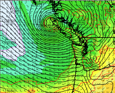
The solid lines are isobars, lines of constant pressure. Where there are large gradients (large change in pressure), strong winds are expected. Folks, there are a LOT of isobars there.
Winds will be ferocious over the ocean, with gusts near the low center reaching 50-70 mph.
I hope no Alaska cruise ships will be traversing the region tomorrow morning. It might dampen the appetites of the passengers.😊
Take a look at the predicted wind gusts at 5 AM Wednesday. Over 50 mph over the Pacific and across portions of Northwest Washington. Going to be very windy in the San Juans, Victoria, and the eastern Strait of Juan de Fuca.

And then as the low center moves eastward across southern BC, strong winds will surge eastward into the Strait of Juan de Fuca and winds will gust around Puget Sound (see the forecast wins at 2 PM Wednesday)

The latest wind forecasts over Seattle indicate the wind potential for Wednesday morning and afternoon (see below). The red line is from the UW high-resolution forecast system...and is usually the most skillful. It is predicting gusts exceeding 40 mph in exposed locations over Seattle. With leaves on the trees, expect some branches to fall.


I do hope the folks in BC and Vancouver Island aren't put through the blender again, they've had a challenging time over the past winter with the cyclones and torrential rain.
ReplyDeleteI'm beyond done with the relentless grey, wind, and cold. Too bad La Niña tempers our occasional summertime thunderstom. Those are fun. These? Not so much.
ReplyDeleteI vaguely remember when Vanvouver BC had 40 consecutive days of rain in the summer ... I think it might have been in 1975, or -76, or therea bouts. Seattle was probably not too far behind
ReplyDelete'Nearly in stitches, reading, watching and hearing newscasts this week. Here's the line, just about everywhere (S-T, TV stations): "People, we've had nothing BUT rain all spring, and it's snowing on Stevens Pass where this makes for a second year of hefty snowpack -- but, gee-whiz that's good news given the risk of summer drought." Hello. Dare I say, "Gaslighting"?
ReplyDeleteEcology's still considering extending "the drought" 'come June last time I heard. Here near Mt Baker we've already exceeded recent avg whole-rain YEAR) precip by over two inches. Yes-yes, there was last year's brief heat spike; nonetheless the summer months weren't dry much less a drought (13.8" May to Sept) in the mtns here. Avg summer rain at this end of the Cascades has been averaging over 14 inches, with no - nil - bone dry months May-Sept (happy forests). Rivers of rain will continue to come our way unless the Pacific is transported to another dimension - no evidence that's in the cards. 'Shouldn't rant, but what's coming down the pipe as 'weather news' this spring is shameless IMHO.