We are now at roughly the halfway point of Northwest winter, and it is interesting to evaluate where we are weatherwise.
In contrast to California, which is experiencing the wettest winter in a generation...if not longer... most of the Northwest has had a muted winter so far, with the December ice storm being the main exception.
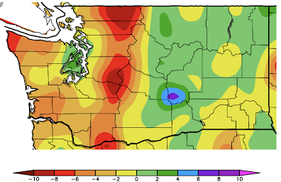
Let's start with the temperature over the past 60 days ( the difference from normal, below).
The entire region was cooler than normal by 0-4F, but eastern Washington and parts of eastern Oregon were MUCH cooler than normal...by as much as 6-8F. Not particularly surprising for a La Nina year.
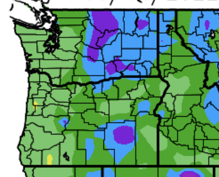
East of the Cascade crest, a large area was slightly wetter than normal (green color). Interestingly the western slopes of the Cascades were below normal by 4-10 inches.


A closer-in view for Washington of the precipitation difference from normal for the past 60 days more clearly shows the dry western slopes of the Cascades, while the eastern slopes are wetter this normal.

Why this pattern you ask?
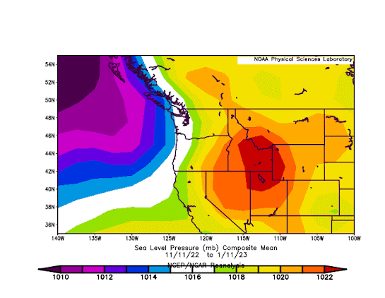
Good question! The reason is that we have had persistent low pressure offshore and higher pressure inland, resulting in offshore-directed easterly flow. So more upslope precipitation on the EASTERN side of the Cascades but less precipitation on the western slopes of the Cascades.
To illustrate the situation, below you will find the pressure averaged for the 60 days ending January 11th. High-pressure inland (red), lower pressure offshore (purple).
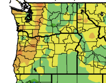
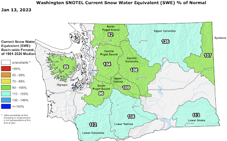
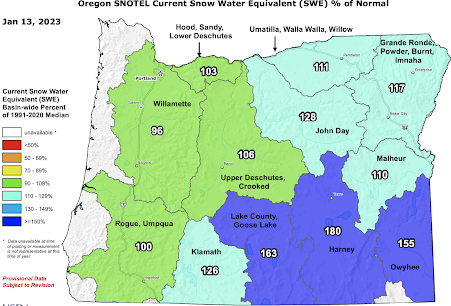
What about Northwest snowpack? As shown below, the Washington snowpack is nearly normal for this time of the year. The same is true for all of Oregon except for the southeast side, which has much more snow than normal.


At this point, I suspect the Northwest will continue this near-normal regime for a while.
The exciting weather story is California, where huge, historic amounts of precipitation--the greatest in over 100 years in some locations-- have essentially ended the several-year dry period. I will talk about that in a future blog.


It sounds like the major reservoirs in California are still below normal, and they aren't expecting the exceptional snow pack to fill them. It will be interesting to see how much more progress there is over the next week. It sounds like California needs considerably more rain, just not all at once.
ReplyDeleteThey are required by law to keep them at some 60% capacity or less through the winter. So they can control flooding if they really get swamped. Snowmelt will help in the summer. They are trying to go to "dynamic" reservoir management, where they would only spill extra water if the forecast calls for a lot more rain than the damage can handle.
DeleteYes, they have to keep at some level below capacity. I'm not talking about capacity, I'm talking about average/normal for this date, for which they were still had not reached a few days ago.
DeleteCare to comment on this weeks Washington Post article on why California's water management team don't feel certain the drought it over, and why you feel otherwise?
ReplyDeletebecause that won't fit their preferred narrative of climate doom. Any facts, data or statistics won't change their mindset, because that specific mindset allows them to dictate to everyone else how to live their lives, down to the subatomic level. It's called Malthusianism, and that is why frauds like Paul Erlich is allowed to be spectacularly wrong regarding his poplulation predictions continually over the past sixty years.
DeleteAny details about why "Camano Island Radar is down until 1/20/2023"? (mentioned here: https://atmos.uw.edu/current-weather/northwest-radar/ ) Thank you.
ReplyDeleteIt's probably down for maintenence and upgrades.Ours in Spokane will be out of service for about a week beginning Thursday.
DeleteWhy do Kitsap, W Jefferson & Everett have nominal or slightly above average precipitation? That looks very close to normal where the rain shadow would be instead.
ReplyDeleteThe Drought monitor still has eastern Oregon in a server drought they need much more rain and snow.
ReplyDeleteWhat's the winter been like in terms of wind? Portland has seemed pretty windy (both east and south). I don't know if there is such a scorecard. Thanks!
ReplyDeleteHere in Bellingham, I continue to note the low amount of precipitation in 2022, at least at our standard reference point, the airport. We have been listed on the drought monitor for some time. 2022 was about 7" below normal. We are about 4" below normal for the current water year. On a longer term basis, for both the 2021-22 water year and the 2021 calendar year, we were above normal, but that was solely a result of 5 days in November 2021 that brought 11′ of rain and major floods to Whatcom County. So far, January is running below normal, but of course, a storm or two could quickly change that. I appreciate that the weather has an inherent lumpiness to it, but we seem to be in a pattern of big extremes.
ReplyDeleteBellingham has about 80% of normal precipitation since October 1. Not a serious issue and easily made up. A big contrast with the very wet year before.
Delete