Did you notice how dry the air was yesterday over large portions of western Washington?
Strangely enough, you can blame a huge storm over the Pacific Ocea!
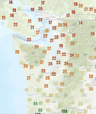
To show you what was going on, below is a plot of the minimum relative humidities west of the Cascades on Tuesday. In some locations, relative humidity dropped to under 20%!
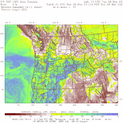
A relative humidity forecast for 2 PM Tuesday predicted very low values (below 20%, brown colors) in western Washington and southwest BC. Low values over eastern WA as well.
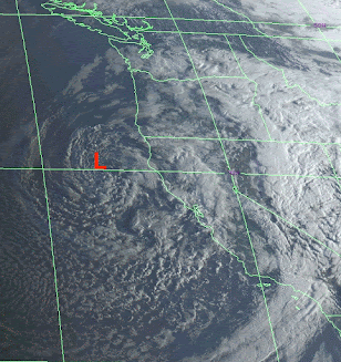
Yesterday's visible satellite image around 2 PM was impressive, with a deep low-pressure area in the center of the swirl and an extensive band of frontal cloud extending around the low to northern Oregon and then south into central California.

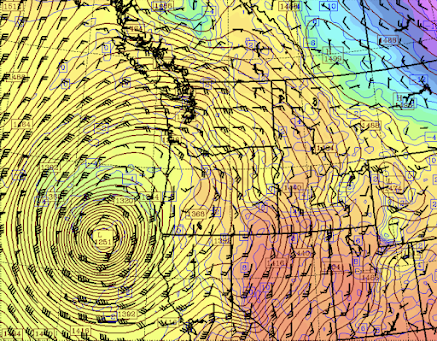
Associated with this storm, there was a strong low-level wind circulation. Below are the forecast winds and heights (like pressure) at roughly 5000 ft (850 hPa). You can see the intense low center off the CA/OR border. Wow.
Now, look at the wind barbs. They indicated very strong easterly (from the east) winds over Washington and British Columbia.
Such winds not only bring in dry air from the continental interior but as the air descends the western slopes of the Cascades and coastal mountains, it is warmed by compression. Warm air can hold more moisture than cooler air, and this caused relative humidity to plummet.
Another factor is that the descending air starts higher up, where the air generally has less moisture.
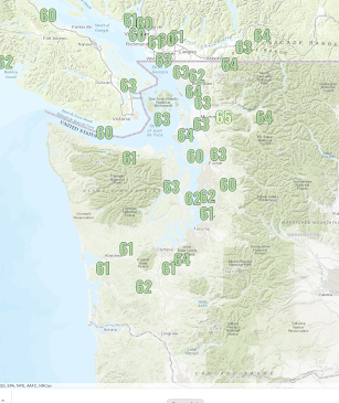
In fact, the warming due to sinking air was very evident in yesterday's high temperatures, with max temperatures rising into the lower to mid-60s over northwest Washington (see below)
a
Needless to say, large amounts of moisture are now streaming from the Pacific into California. If only they had built more reservoirs...
_________
Announcement. I will be having a special online session for my Patreon supporters on Saturday at 10 AM.


The RH at my location in Bellingham fell to 24% yesterday which is quite low for my site and the lowest since 9/20/22.
ReplyDeleteIs this related to the increase in static electricity that I notice? Or is that just coincidence?
ReplyDeleteYes, it's related.
DeleteI wondered why it kept feeling like a high desert wind outside yesterday. Makes sense. The easterly winds dropped the dewpoints at my station to an impressive 17F, and temps zoomed up into the mid-60s. I love these easterly pushes because they are so rare.
ReplyDeleteAnother thing I've noticed about the unusually low RH of the air is how cool it makes the temperature feel (along with the breeze). I checked the NWS heat index calculator and at 4:57PM yesterday at my location in Bellingham the temperature stood at 64.7F with a RH of 30% which results in a heat index of 62F - nearly 3 degrees cooler than the actual air temperature at the time!
ReplyDeleteYes, it makes me chilly too. I enjoy the occasional "Pineapple Express" which brings our highest humidity values, even when there is rain (as long as I'm not going skiing) but California has been hogging them this winter.
DeleteFor my taste, I prefer the lower dew points. Really, my hackles start to raise once it gets above 50F. Once it goes to 60F (and beyond, as has become the norm in my particular corner of the Evergreen State), I'm diving into my wonderfully air conditioned house (the temperature of which I'm quite proud to report that I keep comfortably below 70F during the hot (and, now, humid summer months) as soon as humanly possible!
DeleteCliff, western wa has been dryer then normal the last few months any concern about wildlife season?.
ReplyDeleteHey Cliff. Reservoirs are why a lot of big river systems in the NW are so screwed up. More conservation and better water management by states is a better solution. Decrease demand.
ReplyDeleteIt's now clear that Bellingham will finish out the month of March with well below normal precipitation.
ReplyDeleteThe current monthly total at BLI is just 1.59" and the total that would normally have fallen by the end of the day on 3/29 is 3.14". The current NWS forecast calls for ~0.2-0.25" of rainfall by the end of the month for the area where BLI is located.
The most recent month during which BLI received above normal rainfall was June 2022. October 2022 just barely managed to eke out exactly normal monthly rainfall due to the atmospheric river(s) that occurred during the final week-and-a-half of an otherwise parched, torrid month.
Every month since has received below normal precipitation. The 16.44" of precipitation which has fallen since October 1, 2022 makes this the second driest water year to this point on record behind only October 1, 1993 - March 29, 1994 with a paltry 15.84". In fact, since January 1, 2022, the only months that received at least normal precipitation at BLI were May, June and October 2022.
It also just so happens that the calendar year 2022 was among the top-10 driest such in the BLI period of record dating to January 1, 1949. Some of the 2022 data is missing so I've used precip data (which is very reliable as I triple check my precip data with 3 different rain gauges one of which is a CoCoRahs gauge) from my weather station which is located very close to 2 miles from the ASOS/AWOS at BLI.
My location generally receives more precipitation than BLI reports and using the data from my station to fill in the gaps I found that BLI received ~29" of precipitation during 2022 however the actual total is almost certainly less. I would say that it's likely that 2022 was the 6th or 7th driest calendar year in BLI history and the driest calendar year since 2002 which was the 5th driest calendar year in the BLI period of record.
It's also interesting that 2022 stands in such sharp contrast to 2020 and 2021 which were among the wettest calendar years in BLI history - 5th and 7th, respectively. 2020 and 2021 were also among the hottest years in BLI history at 10th and 8th, respectively, while 2022 was the 20th.
ReplyDeleteUnfortunately it appears that our long dry streak may well continue as the 3-month outlook from the Climate Prediction Center for April-June calls for below normal precipitation.
All I know was it was quite nice yesterday. Tuesday, Tacoma got clouds much of the day, but eked out a 59* by end of day and I got the front yard mowed for the first time this season. Yesterday, it didn't feel hugely warm, but was more than pleasant and did feel to be at least 60* and got the backyard done, and drove to the recycling center to rid of a bunch of bottles.
ReplyDeleteHumidity was definitely not there yesterday, though the winds are still somewhat cool, relative to the radiant heat as it's not warmed up much as of yet as we typically are just now reaching the 50's on a regular basis this month.
At this point, the BLI 2022-2023 water year is also certainly in the running for driest water year on record. The current record driest water year was that of 1993-1994 with 24.01". With the current water year total of 16.44", even if the remainder of the months in the water year (April - September) received their respective normal monthly precipitation amounts, the 2022-2023 water year total would stand at 27.07".
ReplyDeleteSo, 10.63" could be expected to fall during the remainder of an otherwise normal water year. If instead of 10.63", only 7.57" were to fall, a deficit of just 3.06" equal to 71% of normal, the current water year would tie with that of 1993-1994 as the all-time record driest. Given the current 31% deficit for the water year to date as well as the Climate Prediction Center outlooks for drier than normal conditions persisting for the remainder of the water year, this outcome is not hard to imagine.
Not here a little north of Arlington, that's just one recording site so because one station is behind or ahead doesn't mean the area as a whole is the same
DeleteSee my comment below. It was not by accident that I never suggested in any way that the abnormally dry conditions which the Bellingham area has been experiencing are anything other than a relatively localized anomaly.
DeleteI'm no expert, but might I reluctantly predict a wetter than normal spring, based on the fact that the jet stream is south of its normal path and we are still north of the polar front, I presume? The jet will have to pass over us on its journey north. Yes, it does seem like we are way behind on rain for the first 3 months of the year.
ReplyDeleteI might add that the exceptionally dry conditions which the Bellingham area has experienced over the past year or so are more of an exception than a rule as much of the area of Western Washington for which NWS Seattle forecasts has received precipitation amounts which are considerably less anomalously low. As a non-expert myself I can only rely on the historical data as well as the long-term forecasts which clearly suggest that the Bellingham area drought is likely to persist if not intensify as the wet season comes to end next month. So, while (meteorological) spring which is already well underway, may be wetter than normal, or at least not drier than normal, for some areas, I predict with a substantial degree of confidence that the current water year will indeed go down as one of, if not the, driest on record at BLI.
ReplyDeleteFor what it's worth, the jet stream is rapidly on its way north and will migrate north of Washington over the coming week after which it is unlikely to sag south in any substantive sense until next fall. La Nina has already come to an end and El Nino is very likely hot on its heels.
ReplyDelete