This is the season for northward bird migration and the weather is now perfect for northward flight.
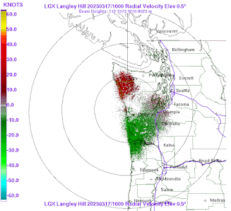
As a result, there is a massive northward movement of birds occurring and the weather radars are lighting up with birds each night.
As I noted in previous blogs, many birds prefer to fly at night, so let me show you the regional radar imagery over the past 24 h.
5 PM yesterday (Thursday) there was nothing
The radar targets are going northward!
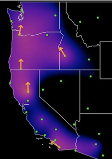
There is a nice website Birdcast, which collects all the radar information and shows migration patterns over the US. Here is theeir graphic from last night, with arrows showing the direction of migration. A large northward movement of birds along the West Coast.
I have noted that birds are a bit picky about nighttime flying weather.
They don't like heavy rain and stormy periods. They also appear to appreciate a tailwind.
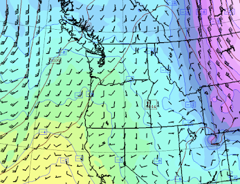
And last night they had one. Below are the winds overnight at 700 hPa (about 10,000 ft). The little barbs show the direction and speed. Southerly and southwesterly flow (from the south to the southwest) was apparent. Not too strong. Just like our feathered friends prefer.
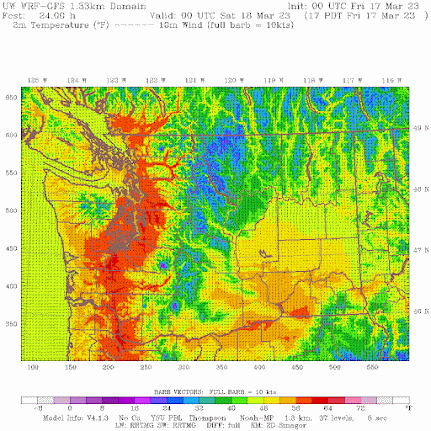
Today will get near 60F in western Washington and some places will get into the lower 60s on Saturday. Take a look at the forecast surface air temperatures on Saturday at 5 PM (below). Red is warmer than green and blue. Wow. Lower 60s all over the place in the western interior.
Warm southerly (from the south) winds aloft plus low-level downslope (easterly) winds over the Cascades are the reasons for the warmth. This will be the warmest period since last October (see plot below, with 60F highlighted). And it will feel good.



It would be intesting to know if the recent deluge of storms with so much snow occuring in CA had anything to do with the recent migration of the birds northward.
ReplyDeleteWhy are the skiies so hazy, an almost opaque white during our clear days the past couple of months? Why no clear blue, blue bird skiies?
ReplyDeleteI noticed that also and it reminded me when several years ago, dust kicked up from Gobi desert wind storms visited our area. Apparently it is not that rare in the spring, see here: https://www.washington.edu/news/2007/12/13/tiny-dust-particles-from-asian-deserts-common-over-western-united-states. Whether that is the case now, perhaps the professor could confirm.
DeleteStrategic Aerosol Injections. Watched them spraying the skies furiously these last two days and that dissipates into complete hazy coverage.
Delete3/17 was a fabulous St. Patrick's Day in Bellingham with perfect early spring conditions that my garden is over the moon for (I grow plants that prefer colder weather and/or require it for germination). The high temperature of 60.1F and low temperature of 28.3F, resulted in a diurnal temperature range of 31.8 Fahrenheit degrees - the largest at my location since 9/20/22. Relatedly, days with highs in the 60s and lows in the 20s are unusual in this area. The most recent previous occurrence was on 3/11/2018. Since we're getting close to the vernal equinox, I'll submit a comment in the near future regarding accumulated solar energy on/near equinoxes and solstices during clear weather.
ReplyDeleteIn fact, it was the first time that the temperature has reached the 60F degree mark during March at my location since the bipolar March of 2019 and, in an interesting coincidence, the temperature reached the 60F degree mark for the first time during March, 2019 on 3/17.
ReplyDeleteI've been posting recordings from the UW Doppler Site to the Pacific NW Birders on Facebook. I just posted this blog to them too. This one is great, Cliff.
ReplyDeleteAlso, as a top maker of Irish Flutes for the last 40 years I can state this with some authority: Gag me with a Shamrock!