In mid-April, Washington State snowpack was near normal, while snowpack to the south was well above normal.
Then Washington experienced much warmer than normal temperatures in late April and May, as illustrated by the temperatures at Olympia below (normal highs are shown by the purple line)
The result of the warmth was a massive melt-off of the Cascade snowpack that has surged into local reservoirs, filling them to normal levels.
For example, consider the Yakima Reservoir system, so important for eastern Washington agriculture (see below). Over two weeks of May, the reservoirs went from below-normal to normal levels.
Or take Seattle's situation. Just like the Yakima reservoir system, with a very fast increase to normal levels during the past month.
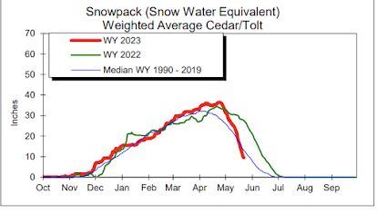
Seattle's snowpack in the watershed feeding its reservoirs is shown below. Wow. A precipitous decline!
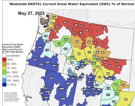
To really appreciate the snowpack decline, below are the last snowpack percentiles around the Northwest. Down to 35% or less in areas of eastern Washington. But bountiful snow remains over southern Oregon and south.
The key issue has been temperature: while Washington has been MUCH warmer than normal, California has been normal or colder than normal (see the proof below)
This pattern (warm north, cool south) has been very favorable: it has slowed the melting of the massive snowpack over California, preventing disastrous flooding and potential damage to reservoirs/dams over the Golden State.
The forecast for the next ten days?
You won't believe it. More of the same (see the European Center forecast, showing the prediction temperature anomalies from normal for the next ten days). Warm north, cool south. Again.
California is going to be saved from major flooding, which is very good news.


The Cariboo mountain snow packs hit zero 3 weeks ahead of normal. Snow pillow measurements in the Okanagan near Kelowna reveal still lots of snow. Confirmed: warmer up north
ReplyDeleteHi Cliff. As a climber im seeing and hearing of climbs that are looking ahead of where they usually are due to the rapid snow melt. I wonder what this means for the fire season. We had a healthy snowpack which is rapidly diminishing leaving our unhealthy, poorly managed forests exposed to a single stray spark. Im tired of beating this drum but noone wants to hear that we need to manage the forests. I live close to NF land which is a forest choked with thick brush and deadfall, a result of decades of fire suppression. If it goes up, many thousands will be displaced. Anyone who feels bad for trees needs to see one quite literally explode like a bomb when its set on fire.
ReplyDeleteThe association between snowpack and fire risk should be location dependent. Keep in mind that snow persists into May or June only at high elevations. The melting snow reaches lower elevations having already been channeled into streams and rives. As far as I know, snowpack has relatively little effect on the low to mid-elevation soil moisture late in summer, and therefore, relatively little effect on fire risk.
DeleteThe fire risk is affected more by the amount of summer precipitation, and high risk weather conditions, which for western Washington means the dry easterly winds Cliff has written about quite a few times.
Of course, higher elevation soil moisture is more affected by how long the snowpack sticks around.
Kachess Lake is soooo low this year, compared to last. I guess last year was above average, but the difference is astonishing.
ReplyDeleteThe remaining snowpack data seems somewhat threatening, but the graph appears to reveal that even with the recent meltoff we're close to median. A few days ago my wife and I drove up Highway 2 and then up the Miller River Road (from Money Creek bridge, just a 1/3 of a mile past Grotto). The snowpack on the ridges above the Miller River, and east toward the Foss, Tye and Beckler Rivers, appear to have relatively normal amounts of snow remaining. Anecdotally my observations incline me to conjecture that if we get cooperative weather patterns that at least the west side and central Cascades may escape serious fire conditions.
ReplyDeleteIf snowmelt drove all hydrology-hydrogeology, the SNOTEL-based map would have more meaning. The melt from glaciers and snowpack accounts for just one part of water supply; and frankly, the contribution of snowmelt is only significant in some watersheds. Most places rely on groundwater; water tables and aquifers are recharged by direct precipitation (rainfall, infiltration). Everywhere, when it rains the surplus runoff (stormwater) gives streams and rivers a temporary boost. I encourage people to put more effort into understanding the mechanics (hydrogeology) to get a grip on what drives streamflow, and get a grip on the differences between "ephemeral," "occasional," and "continuous" flows.
ReplyDeleteThe USDA SNOTEL data indicates a much lower than average remaining snow pack. The current percentages compared to the median are 51% for the Puget Sound area, 67% for WA coastal, 39% for Yakima, and 32% for the Upper Columbia (north of Yakima). The first link of a google query using 'usda snotel interactive map' will get you the base map and so much more if you dig around, there is a wealth of data there! PS, I'm going to purchase an air purifier right now for my home.
ReplyDelete