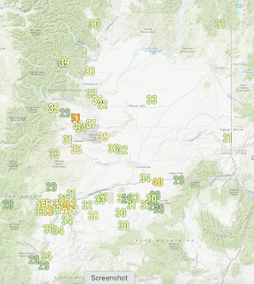
This has been a very windy period over portions of eastern Washington due to a large pressure difference across the Cascades (higher pressure to the west, lower pressure to the east).
The maximum winds today since midnight (see below) reached 51 mph near Ellensburg. Winds were mainly strong near and downstream of Ellensburg and east of the eastern terminus of the Columbia River gorge.
A model forecast for this afternoon shows the two main wind plumes over eastern Washington. One east of Cle Elum and Ellensburg and the other downstream of the Columbia Gorge (stronger winds shown by the blue and greenish colors).
So why are the strong winds in eastern Washington localized?
It has to do with the variable height of the Cascades and specifically two lower areas in the north-south barrier. Below is a terrain map for Washington and northern Oregon, with the green colors representing lower elevations. Note there are two lower regions across the Cascades: a near-sea-level Columbia Gorge between Oregon and Washington, and the "Stampede Gap" region of the central Cascades (with lowest elevations around 3000 ft), which also includes Snoqualmie Pass.
Both are indicated by red arrows.
When a large pressure develops across the Cascades, with higher pressure to the west and lower pressures to the east, winds surge through these gaps, creating two major westerly wind swaths over eastern Washington. A minor wind swath can also be produced downstream (east) of Stevens Pass.
The winds exiting these Cascade gaps strengthen during the evening after the daytime heating in eastern Washington causes the pressure to fall there (and thus increasing the pressure difference across the Cascades0. To illustrate, below are the winds forecast for this evening (in mph)...a lot more greens in eastern Washington, which means stronger winds.

With cool/high pressure to the west of the Cascade crest the last few days, the pressure pattern has been very favorable for consistent westerly winds over the wind turbines of eastern Washington, producing consistently high wind energy availability (see the Bonneville statistics below, wind plus solar shown by the green line).
As noted in my earlier blog, the total of wind and solar is roughly one-third of the demand (red line). Hydro generation (blue line) has been allowed to decline because of the bountiful wind energy.
The latest forecasts suggest the west side will warm and wind energy will thus decline substantially over the next few days.


All very interesting. But we are six inches behind on rain for the year, and while I enjoyed the relatively sunny and dry May, I do hope we get some quick heavy shots of moisture in the next month or so. Otherwise it will be smogast and smoktember by late summer... Comments?
ReplyDeleteIf we're lucky all we'll end up with is a smoketember...and if not, a smoketober and a smoketember too
DeleteI would not call that lucky...
DeleteThis is the driest spring that I can remember in recent years... Cliff can you comment on our rain situation ina future blog? Im encouraged by your reservoir updates but the lack of rain is worrisome.
ReplyDeleteI second that. I hate to complain about sunshine but it is usually feast or famine around here, meaning, the pattern seems to change less frequently on the west coast than it does in most other parts of the country.
ReplyDelete