I have gotten several nervous emails from folks concerned with the relatively dry period of the past month over the Pacific Northwest.
Are such dry conditions unprecedented?
Are late springs getting drier?
Is global warming behind it? Or El Nino?
I will try to answer the questions below.

Let's check the numbers, starting with Seattle. Below I have plotted the total precipitation for May 1 through June 5 for SeaTac Airport and added a best-fit trend line as well.
You will note that our recent period was dry, but not the driest by far.
.png)

What about the other side of the Cascades? Let's consider the long-period observation location at Kennewick in the Tri-Cities.
Similar story to Seattle. We have had a dry period, but it has happened before many times, and the trend is towards a WETTER late spring.
.png)
According to the records, this recent period was the 10th driest on record at Kenniwick.

The bottom line is that we had a dry period, but such dryness in late spring is not that unusual and there is no trend towards drier conditions in May and earlier June. No suggestion that global warming/climate change is the cause.
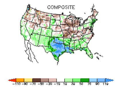
What about El Nino?
El Nino conditions in the tropical Pacific have only really developed during the past month, but let's check out the NOAA Climate Prediction Center historical precipitation anomaly from normal for April to June during El Nino years (below). A very mixed bag over Washington State. Wetter than normal over the Southwest.
Now if I blog about the lack of precipitation, you KNOW what is going to happen in the future.
Below is the latest total precipitation forecast through Friday at 5 PM. Lots of precipitation (many from thunderstorms) east of the Cascade crest, with perhaps a few errant showers getting into western Washington. Bountiful precipitation in northern California.


The first 7 days of June at BLI have all had daily minimum temperatures <50F for the first time since June 2001 though as of 6/6 the monthly mean temperature is exactly average as daily maximum temperatures have been warmer than normal. In fact, the first week of the month has been typified by relatively large diurnal temperature ranges with an average 23 Fahrenheit degrees between daily high and low temperatures compared to a normal average of 16 Fahrenheit degrees for the period in question - a testament to the dry air that's been entrenched over the area. Speaking of dry air...if "the recent dry period" is taken to mean the calendar year then it has been unprecedentedly dry at BLI with just 7.38" of precipitation since January 1, 46% of the normal total of 16.14". The first half of 2023 will easily be the driest first half of any year in the 75 year period of record at that location. Furthermore, the current water year total precipitation at BLI of 19.02" is precariously close to the all-time record minimum and will almost certainly eclipse the 1993-1994 water year for that unfortunate distinction by the end of the month.
ReplyDeleteFor all you nervous Nellies out there, I agree with Cliff here. I grew up in the Tacoma area and lived in Seattle between 1996-2016 when I moved back to T-Town and in the RECENT past, we've had some very dry springs and by the 4th of July, grass is very much brown, and stays that way much of the summer, only starting to green up when the fall weather begins to set in. Some springs, it's wet and grass does not fully dry out until mid summer, other years, it's turning brown in June, like it seems to be doing already this year.
ReplyDeleteI remember driving north along I-5 and the interchange between SR-16 and I-5 NB the grassy median along the sides were already brown by the 4th of July.
So this is not uncommon to see May/June be dry some years, other years, it's cool and wet well past June.
So just calm down, it's nothing to wring your hands about.
I'm beginning to think that this account is either Greta Thunberg in cognito or Michael Mann's.
ReplyDeleteCliff Mass is a gem. We are so lucky to have him. This is great content which answers exactly what I was wondering.
ReplyDeleteCliff I love your blog; long time follower. My humble request: please leave Blogger. It is a terrible platform. I can't get your updates by email, and rss is a dying tech. Would you consider moving to something like substack?
ReplyDeleteLooks like something went wrong on that precip model ending 5pm today. Current radar shows just about all of western Washington from Seattle south being inundated. Definitely more than an errant shower. And that model showed the precip being north of Seattle, not south. What happened?
ReplyDelete+1 for moving to Substack
ReplyDelete