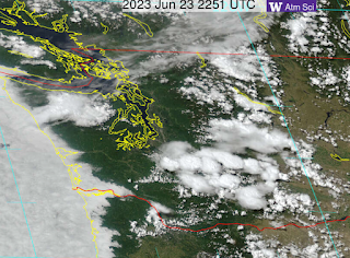
On Thursday, Friday, and Saturday of this week, we had a number of days with thunderstorms over the Cascades and Olympics, but little activity near sea level, something very obvious in a visible satellite image early Friday evening (see below)
And don't forget our ability to map every lightning stroke from the several lightning networks that sense the electromagnetic pulse from each stroke. Here are the lightning strokes on Thursday--the preference for higher terrain is obvious.
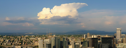
On Friday around noon, I was flying back from a meeting in Boulder, Colorado (at the National Center for Atmospheric Research) and I took some pictures of the developing cumulus clouds over the central Cascades (see below).
Flying near the Cascade crest (south of Snoqualmie Pass)
And then looking back from the lowlands, where it was clear.
So why are the mountains favored for thunderstorms and not the lowlands?
And why were mountain thunderstorms so active this week?
A key reason is that the air is more unstable over the mountains than over the lowlands.
Thunderstorms are a form of convection in which air parcels accelerate upwards. A key requirement for convection is a large change in temperature in the vertical. So cooling aloft or warming near the surface helps increase that vertical temperature change (gradient) that promotes convection. You all have experience with convection when you heat up hot cereal, with rising currents of oatmeal occurring as the bottom of the saucepan is heated.
Over the mountains, the temperature change with height is greater because the mountains act as an elevated heat source (see schematic below). You can consider that the temperature is the same at a high level above both the mountains and lowlands, but the mountains act as a heater at some elevation (from solar warming during the day), squeezing the zone of temperature change into a narrower height range.
That produces a larger temperature change (gradient) aloft that enhances the instability that revs up thunderstorms. Meteorologists have a fancy measure of the instability called CAPE (Convection Available Potential Energy), and a map of CAPE on late Thursday afternoon (5 PM) confirms that it was more bountiful over the mountains than over the lowlands.
Thunderstorms are more frequent over mountains for another reason. Upslope flow develops on the slopes during the day and such upslope flow converges at the top, producing a strong upward current of air that can promote cumulus clouds and thunderstorms (see plot).
Finally, why was this week so "favored" for mountain thunderstorms.
We are now in early summer when the sun is able to effectively heat the mountain slopes. Furthermore, the melting of the lower-elevation snow allows the ground to warm up in a way impossible during the cooler seasons.
But there is something else. We have had cooler than normal air aloft associated with a cold, trough of low pressure (see 500 hPa map, about 18,000 ft) on Friday at 2 PM, below). Green and blue colors indicate cooler temperatures.
The cold trough of low pressure will be hanging around during the next new days, so expect more mountain thunderstorms. And don't expect any heatwaves in our future: temperatures will be in the upper 70s for the next several days. 😋😀


True, true! Excellent synopsis.
ReplyDeleteI was doing trailwork on the edge of Mt Rainier NP on Friday and we ended early due to thunderstorms. We got some decent hail and heavy rain, plus loud thunder claps (no lightning though).
ReplyDeleteNo more than 45 minutes drive away in Enumclaw it was sunny and 20 degrees warmer. It was a very cool experience. Thanks for the information post, Cliff
Back in the summer of 1978, a friend who was an avid backpacker and mountaineer invited me on a July 4th hike to Imogene Lake which is south of Redfish Lake in the Idaho Sawtooths.
DeleteI was a sometime backpacker in reasonably good physical shape at the time. This holiday expedition revealed that mountaineering as physical exercise is in a league of its own compared to simple backpacking.
We started off at the trailhead on the north shore of Redfish Lake about 10 AM and were at Imogene Lake about 4 PM, taking time along the way to gab with the sometimes numerous backpackers we encountered along the way. Especially the lady backpackers.
We were each carrying roughly 60 pounds of gear in our packs, the usual overnight camping stuff plus the mountaineering gear.
Every extra pound you carry seems to have a logarithmic effect on one's perception of the stresses of a hike. Especially if you are carrying 60 pounds as opposed to 40 pounds or less.
We got up early the next day and took the mountaineering gear with us to a snow covered ridge to the east, with plans to cross the ridge, come down the other side, and then hike back to camp along the base of the ridge.
When we got near the top of the ridge, about forty feet from the top, a thunderstorm was in progress. When blue sparks started coming out of our crampons, we decided against crossing the ridge and went back to our camp the way we had come up, spending the remainder of the afternoon reading Isaac Asimov novels.
The next day we got up early, packed our gear, and left the lake about 8 AM with the goal of making it back to the trailhead by noon, a distance of about nine miles. We got to the trailhead a little after noon and packed the gear into the back of my pickup truck.
We got into the cab to drive off but I then discovered I was unable to press the clutch down. After about ten minutes, enough strength had come back into my left leg to operate the clutch, and so we were able make our 5 PM dinner date with other friends at a restaurant in Sun Valley.
They all thought we were nuts to be doing what we did along that snow covered ridge.
Hi Cliff, i was out hiking around the Cle Elum area today and a thunderstorm started forming around 1pm over Mt Stuart and grew steadily larger with frequent thunder. What was strange is that the storm didnt appear to move, it seemed stationary and was still going at 5pm. I could feel the cold downdraft as I appeared to be on the edge of the storm. What causes the storm to be stationary as i thought that they always moved in the direction of the upper level winds. Needless to say that my hike was cut short as i didnt want to risk being on an exposed summit in a storm.
ReplyDeleteExcellent explanation. I grew up in North Florida and EVERY front that came through had lightning. Usually the kid of the house had the job of unplugging everything as a front approached, in an era before surge protectors. Say what you will about the weather here, but I don't miss that one bit!
ReplyDeleteThank you! You explained something I thought I knew already but really didn't
ReplyDeleteThese storms often reach the Cle Elum area and north into the higher mountains. Hardly ever do they reach the Ellensburg area. Years ago, a WTA (trail crew) camped near a small cirque lake about a mile west of where the PCT crests at the top of Deception Pass, 30 miles north of Cle Elum. We were treated (thrilled) to lighting and thunder – with sound bouncing around the walls of the cirque and then seeming to head north toward Hwy #2. "like a south bound train"
ReplyDeleteI would certainly not agree that they "hardly ever" reach Ellensburg. It has already happened two or three times this spring/early summer.
DeleteYes- that's what I thought. The mountains are stealing our thunderstorms. Go hiking in the mountains, I guess.
ReplyDeleteC4 grasses (like cheatgrass) thrive in elevated CO2 conditions which raise the risk of fire. This is not debatable.
ReplyDeletePatschwap... CO2 increases the productivity of all plants, from trees, to crops, to grasses. I suspect the modulation of the fire risk is small....do you have any explicit evidence of the impact?..cliff mass
DeleteThe impact of recent increases in atmospheric CO2 on biomass production and vegetative retention of Cheatgrass (Bromus tectorum): Implications for fire disturbance. Lewis Ziska at US Dept of Agriculture, 2005.
Deletealso this organization:
https://www.invasiveplantswesternusa.org/climate-change-impacts-on-c4-plants.html
For more information on CO2 levels and how plants respond, Duke University has been doing great research over the last two decades in this field.
https://today.duke.edu/2023/03/climate-lessons-plants-past-future
Yes, one of the few bright spots in a future with increased CO2 in the air will be that all manner of plants, from crops to trees, will (other factors being equal) grow faster, and in so doing help use up the CO2.
ReplyDeletethis comment reminds me of the "Greening of America" propaganda/ad campaign by the fossil fuel industry that tried to paint elevated CO2 levels as a net positive.
Deletehttps://www.theguardian.com/environment/2021/nov/18/the-forgotten-oil-ads-that-told-us-climate-change-was-nothing
I can see that I should have hurried to say that I NOT advocating complacency regarding the burning of fossil fuels nor should we relax our efforts to develop alternative energy. I simply meant that, as with many things, there is at least a little bit of mitigating effect mixed in the all the bad effects of increased CO2. But certainly it's not a net positive.
Delete