If you want sun and warmth, don't travel to southern California during the next week.
Stay in the sunny Pacific Northwest, where the weather will be as close to perfect as one might imagine.
Much colder than normal water is found off the West Coast from Oregon to Baja, and southern California is cold and enshrouded with clouds (see visible satellite image a day ago). June Gloom+

Sea Surface Temperatures
Here is the latest plot of sea surface temperatures along the West Coast, with large stretches below 50F (purple colors, below 10C). Too cold to swim in!
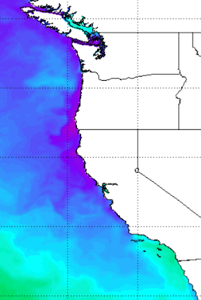
Much of the offshore waters are well below normal, as indicated by the blue colors below.

Why are the coastal waters so cool? Probably, two reasons.
First, there have been persistent, unseasonable low-pressure areas that have repeatedly formed off southern California.
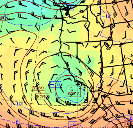
To illustrate, the upper-level heights at 500 hPa (think pressure around 18,000 ft) this morning are shown below. A low with a nice counterclockwise circulation is just offshore of southern California. Such lows are associated with stronger winds and atmospheric disturbances that stir up the upper ocean, mixing cooler water from below up to the surface.
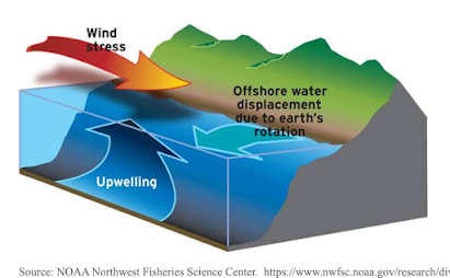
And then there have been periods when high-pressure builds offshore and northerly winds develop over the waters of northern CA and Oregon. This pattern results in coastal upwelling of cold water within 100 miles or so from the coast (see a schematic of coastal upwelling below).
Unfortunately for the chilled residents of coastal California, powerful northerly winds will develop offshore this week as a strong high-pressure area builds over the northeast Pacific (see forecast pressure and winds for Sunday).

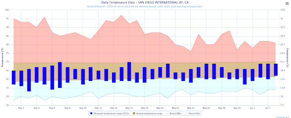
And the frigid situation (with rain by the way) is not ending. Below is the latest extended temperature prediction for Los Angeles Airport. Not a single day above the mid-60s. Boring and cold.


I suspect you will see the front page of the Seattle Chamber of Commerce website reflect the new weather realities:


Yes, the ocean never is warm enough for swimming here. But I am already swimming in Martha Lake (Lynnwood) this year and, with trepidation, Lake Washington.
ReplyDeleteMichael Snyder from pnwww said the effects of El nino are already taking effect that's why California is cooler than normal and we been warmer than the normal for the most part, just watch he's latest videos but I'm sure you'll disagree unfortunately after all he's just a amateur.
ReplyDeleteHe is not correct and yes he is an amateur. Go to the office NOAA website found https://psl.noaa.gov/cgi-bin/enso/enso.pl?output=2&variable=air.2m®ion=globe&event=e&season=sum&type=anom
DeleteYou will see little temperature signal for El Nino summers over southern CA.
El Nino is having an effect already on the subtropical Jetstream already, Daniel Swain agrees. As for the PacificNW weather i haven't made any statements related to ENSO conditions and the PacificNW, for the record.
DeleteAlso I get paid for what I've done for many years, so I don't really fit the description of amateur :)
Michael...the cool/wet California situation began before the switch to El Nino. What effects are El Nino having on the subtropical jet? Please provide your evidence. Swain's speculations on his blog are without any basis ...cliff
DeleteI enjoy Michael's vids for the most part, but lately he's become extremely click - baity with his work. You don't need daily vids with all of the screechy titles. If that's how he "gets paid," well...
DeleteDeveloping El Nino likely contributing to enhancement of the subtropical jet. This can be a different reason for the cool and wet period earlier in the year, the 2 don't have to be linked. ENSO plays directly into Walker Circulation, impacts on Jetstream,so its completely possible that the Developing El nino is having an impact on the temperature gradient across the north eastern pacific and Possibly enhancing the subtropical jet stream.
DeleteMichael...this is not how science works. First, can you must show that the subtropical jet developed with El Nino development during the last last months. Next, can you show that El Nino is likely the cause. And if so, can you show that the subtropical jet played a role in the precipitation during the last months. You need a chain of evidence....cliff
DeleteYou don't talk about the key aspect of science.... testing the hypothesis with data. You are not correct that historical data is unimportant....it is critical. Anyway, there are a lot of errors in the above.
DeleteMust be why the whale watching has been so good off Santa Cruz and Monterey. Lots to eat.
ReplyDeleteI grew up in the East San Gabriel Valley of Southern California which were generally pretty warm by June and definitely by July. August and September were actually the hottest. I went to graduate school at UC Irvine and there was a strong marine flow in late spring and early summer. I recall a July 4th in the late 70's where an outdoor picnic had to be moved inside because it was so cold and damp from the fog coming in off the ocean.
ReplyDeleteMay Gray and June Gloom were my favorite months in San Diego. One of the many reasons I moved here. :-D
DeleteThis grumpy PNWesterner would like some rain, please. My poor rhododendrons and hydrangeas were very dry and I can't ever remember having to water them this early. I'll take May and June 2022 any day over this seemingly endless dry sun.
ReplyDelete