Since summer just arrived, it is natural to examine the extended forecasts for the first portion of our warm season.
There is substantial forecast skill for the next ten days, particularly if one examines the ensemble of many predictions of the best forecasting system in the world: the European Center.
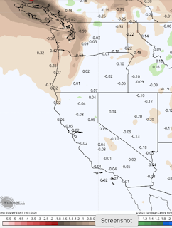
Below is the EC prediction for precipitation (the difference from normal) for the next 10 days. Drier than normal over western Washington, but near normal over California and east of the Cascade crest. This is good: the areas of historical wildfires expect to have near-normal precipitation.
For temperature, most of the West will be cooler than normal, except for western Washington and BC, as well as the Columbia Valley, with the warm areas of Washington being only modestly above normal. We have seen a lot of this pattern during spring.


Turning to July precipitation, conditions are predicted to be near normal along the West Coast.

The bottom line in all of this is that California looks to be generally cooler than through July-- helping keep the wildfire threat down there, particularly since it has been so wet over the Golden State. For Washington State, conditions look relatively close to normal, except for western Washington should be modestly warmer and drier than normal, during the month that is typically the driest of the year.
As I will describe in an upcoming blog, it is increasingly looking like this is going to be a relatively benign smoke year over the West Coast--with high confidence over the next month. The wildfire threat is suppressed in BC and California. The pattern of lower pressure (troughing) over the West Coast, so dominant in spring, appears to be hanging around into summer. And this pattern is not favorable for western wildfires.
The Weather of the Western Cascades w/ Cliff Mass | Facebook


Near normal precip east of the Cascade Crest is near zero. For S.E. WA, July and August near .5 inch, September .75. Out in the basin, less.
ReplyDelete