Northwest weather, particularly over the western side of the region is about to change profoundly.
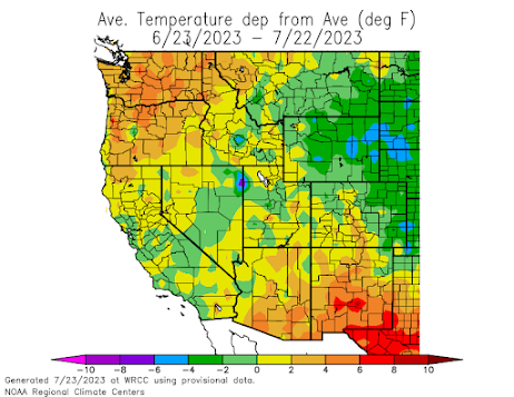
For the last month, much of the region has been warmer and drier than normal, in contrast to much of California, Nevada, and the Plains States that have been cooler and wetter than typical (see temperature differences from normal for the past 30 days, below)
But now the models are in agreement: an unusually strong Pacific front will move through late Monday, bringing wetting rain to the region and much cooler temperatures.
Furthermore, the extended forecasts indicate moderate, typical temperatures for the following week, with no regional heatwaves for the remainder of July.
Take a look at the total precipitation predicted through 5 AM on Tuesday. Several tens of an inch over much of western Washington. Southwest BC will be even wetter.
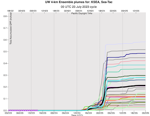
To get an idea of the timing and the uncertainties in the forecast, below is the predicted precipitation accumulation at Seattle from the UW ensemble system of many high-resolution forecasts. Time increases to the right and the average of all the forecasts (usually a good prediction) is the black line. Time is in UTC (00/25 is 5 PM Monday)
Quite a bit of uncertainly in amount, but you can bet on several tenths of an inch in Seattle. Precipitation should mainly fall Monday night as the front moves through.
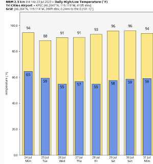
Temperatures will not get out of the 60s on Monday, before moderating to the 70s:
And there will be substantial heat relief for our friends in eastern Washington, with temperatures dropping generally into the low 90s.
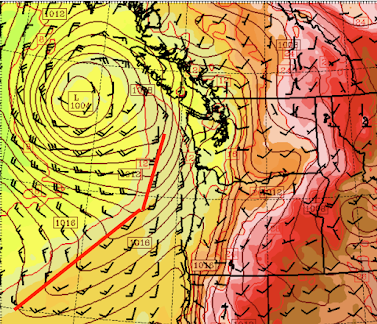
This cool bounty is associated with an unusually strong low-pressure system and a cold front that will move in on Monday. Below is the forecast sea-level pressure map for Monday at 11 AM (low-level temperatures are also shown by color shading, and I indicated the frontal location with the red line).
Wow...a 1004 low with some strong winds behind it, and the front is still offshore at this time.
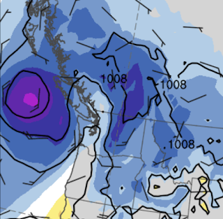
As indicated by the standardized anomaly chart at the same time, this low is highly unusual for this time of the year (the light purple color indicates an anomaly from normal more than four standard deviations for the mean).
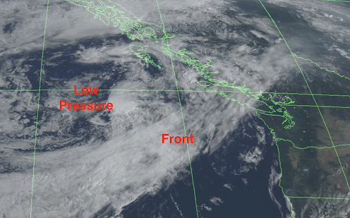
The latest (Sunday morning) visible satellite image shows an impressive offshore front for this time of the year:
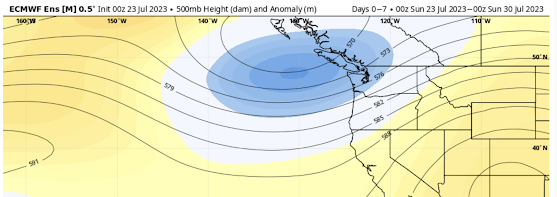
Importantly, the highly skillful European Center ensemble of many forecasts suggests that the upper-level trough of low pressure associated with this surface low will remain in place for the next week (see forecast below, blue indicates lower-than-normal pressures aloft)
This pattern should lessen the wildfire threat over the region, although grass fires east of the Cascade crest can still occur and can be aided by the strong westerly winds encouraged by westside cooling.
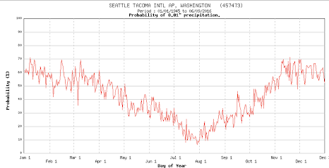
Finally, let me end by noting that the rain tomorrow will be ironically occurring during one of the climatologically driest days of the year over western Washington (see below)
It is all downhill from here.😆




A fire east of Goldendale is, I think, the only major-area one.
ReplyDeleteI am cynical about Everett getting any rain to speak of...the dreaded "rain shadow" seems to dominate this part of W. Wash....I will still be using my sprinklers!
ReplyDeleteI have been doing a rain dance non-stop since seeing the forecast. My only question now is who we throw into Mt StHelens to guarantee it
ReplyDeleteRainbow 🌈 to the west, and then rain half hour later in north Bellingham.
ReplyDeleteThat morning rainbow was beautiful, with the dark red sunrise in the east
DeleteAre summers getting drier in Western Washington or is it my imagination? It seems like 20 years ago we'd at least get some rain, but it seems like recently the trend is for almost no rain.
ReplyDeleteNo significant long-term trend. Proof here: https://psl.noaa.gov/cgi-bin/data/timeseries/timeseries.pl?ntype=2&typediv=2&state=+45&averaged=11&division=11&year1=1900&year2=2022&anom=0&iseas=1&mon1=5&mon2=7&typeout=2&y1=&y2=&plotstyle=0&Submit=Create+Timeseries
DeleteI believe the data. Thanks Cliff!
Delete