A major, and early, blast of Arctic air will move into the Pacific Northwest during the next few days.
Snow will move into the Cascades and large areas to the east. In a few locations east of the Rockies temperatures will drop into the single digits.
Let me illustrate this frigid turn of affairs by showing you the predicted surface air temperatures over the next week.
I warn you....you will be thinking about a nice cup of hot chocolate before you read very far.
The situation at 5 AM Sunday, shows really cold air (white and purple colors) up in the Arctic, where it belongs. Temperatures have been steadily cooling over northern Canada and Alaska during the past month.
But by Tuesday morning, the cold air will surge southward into British Columbia and Alberta.
And Thursday morning, Arctic air will spread over the entire Northwest, except for most of western Washington and Oregon. The chilly exception is Bellingham and its vicinity.
And that cold air will remain in place at least through Saturday morning (see below).
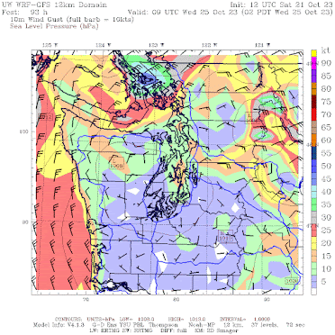
Northwest Washington including Bellingham and San Juan Island will be hit by this Arctic Express as cold air surges southwestward through the Fraser River Valley. Below are the forecast winds for 2 AM Wednesday. Gusts to 40-50 kts, with temperatures in the 30s! Wow. This is going to be quite the cold shock.
Temperatures in Montana and North Dakota will be particularly impressive with lows at Minot, ND dropping to around 12F and temperatures never getting above freezing. Some Montana locations will cool below 10F.
Let's be clear, the cold hitting the region will be dangerous for homeless individuals, who will not be prepared for the temperatures. And you should never forget that cold temperatures kill far more individuals than heat waves. You won't hear about this in the media, but it is absolutely true.
Some moisture will accompany the approaching Arctic air, with significant early snow as a result. Below is the forecast snow total through 11 AM Thursday. Plenty in the Cascades. Northern Idaho and Montana will get a light blanket of the white stuff.
In short, get ready for a substantial, if not shocking, change in the weather. The Arctic is coming to us in the Northwest.


Cold in Bellingham and mild in seattle, Bellingham has always been the icebox of puget sound.
ReplyDeleteI am trying to figure out if it has been extra humid lately. A coworker and myself have noticed we have been sweating more at work (teachers). My co-worker thinks it is the Covid booster we both received in early/mid-October. I thought it might be higher than usual humidity. My data analysis skills aren't great and I haven't really put the time in, so if anyone knows, please let me know. Thank you for this wonderful blog!!
ReplyDeleteHere in the Upper Eastside neighborhood of Olympia--just east of Budd Bay--the lows for W,Th,F, and Sa are forecast by NOAA to be 33,35,30,30--slightly lower than those for Bellingham--34,35,32,33. NOAA however is predicting a possibility of snow for Bellingham Tuesday night and Wednesday while we will not have that. Guess, however, I better put our hoses away as it is not unusual for the actual low to be 4 to 6 degrees lower than the forecast.
ReplyDeleteThanks Cliff! Do you think this snow will persist for the season in the mountains or melt off before winter?
ReplyDeleteThe average date of the first daily minimum temperature of 32F or below for the season at BLI (1991-2020) is 10/25 and the average date of the first daily maximum temperature of the season (1991-2020) below 50F is 11/1. Looks like we'll be hitting those marks pretty much right on schedule.
ReplyDeleteGood thing I just set up my indoor grow light and brought in my dwarf lemon tree. Though I did not know this would be so imminent. Not sure I'm looking forward to it...
ReplyDeleteThanks for the heads-up. Will be watching, observing. More information helps to fine-tune the models, yes?
ReplyDelete