During the autumn, as the jet stream strengthens and moves south, our weather becomes more variable, with very pleasant warm periods interrupted by significant rainfall.
And that is what is in store for us during the next ten days, after a much wetter than normal September.
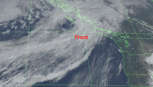
The current visible satellite image shows a weak front lurking offshore (see below), and this front is moving in tomorrow morning, bringing rain to the commute.
So Monday will be wet and cloudy, with the total precipitation over the region being modest; the high terrain will receive perhaps a half inch of rain.

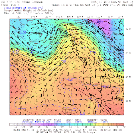
Then we get several days of dry conditions and warming, as a major ridge of high pressure builds over the eastern Pacific and slowly drifts over the West Coast (see upper-level... 500-hPa height-- for 11 AM Thursday).
Temperatures in western Washington will slide up into the lower 70s, with totally dry conditions. Very nice. Perfect for an autumn hike, walk, or bike ride.
The 72h precipitation total through 5 AM, Wednesday 11 October is substantial, with some of the mountain areas receiving 3 to 7 inches. More the terrain of SW British Columbia.

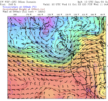
During that period, a deep upper-level trough will form over the eastern Pacific (see forecast chart for Wednesday morning, Oct 11). California will escape the cool/wet onslaught.
And this upper-level trough will spawn ANOTHER deep surface low off our coast--so expect some big waves hitting our ocean beaches (see sea level pressure forecast for 2 AM next Wednesday).

Bottom line: current forecasts suggest a typical October for our region.
______________________________________
Final reminder. I am teaching ATMS 101 now and those over 60 can sign up through the UW Access program as an auditor for about $25.


I guess time to tarp my boat!
ReplyDeleteOver the past few weeks I've noticed the local weathercasts here have been emphasizing the current US Drought Monitor, which Cliff has repeatedly examined to be wanting regarding the efficacy of their measurements on the actual drought conditions in the PNW. They're already using this upcoming dry period to extrapolate (yet again) their erroneous conclusions about some kind of dire situation right at our doorstep. Then I read this bit of ridiculousness -
ReplyDeletehttps://www.theatlantic.com/science/archive/2023/09/new-york-heavy-rain-flooding-state-of-emergency/675505/?utm_source=pocket-newtab-en-us
This information warfare on humanity never ends.
Well NWS Spokane released a graphic of precip amounts over our region, Omak, my home area 110% of normal, yet we are still in drought. Rain will be nice though and if could get a freeze to kill off these clingy flies that would be nice.
ReplyDeleteHere in Everett, I look forward to much cooler temps...my local coffee stands are under siege from yellow-jackets, who seek to access the various sweetened flavor syrups on their shelves! I watch the gals making my coffee, to make sure I do not find myself drinking a soggy, enraged bee!...This happens every year around this time period...I do not know how those ladies put up with those pesky critters, but they do...by November, those bees are history.
DeleteExciting!
ReplyDeleteI was absolutely amazed driving into Newport, Oregon in quite heavy rain on September 23 to see a great big lighted sign urging people to conserve water becasue of the drought. More arrant "climate change" nonsense!
ReplyDelete