Thunderstorms have been relatively rare this summer, but today will see some boomers over the Cascades and eastern Washington.
In fact, there were quite a few thunderstorms yesterday over southwest Oregon (see below, each dot is a lightning stroke) and this activity is moving north as I write this.
So what is going on? Let's start with the visible satellite image around 7 AM this morning (below). I have a red arrow pointing to Seattle.
Wow. An impressive-looking band of clouds stretches north of the Oregon/Washington border from the ocean to eastern Oregon. That is a change.
This band even has some lightning in it (see the lightning flashes at 6AM below)
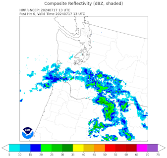
The radar (below) indicates some precipitation with it, although little is reaching the ground.
Why is this cloud/rain band there?
The key is that the persistent upper-level ridge (high pressure) has moved inland and an upper-level trough is approaching (see upper-level map--500 hPa pressure/roughly 18,000 ft) below). The heights (think pressure) are shown by the solid lines and the shading shows relative humidity at that level, with white being the highest.
A trough is moving northward along the Oregon coast. The approach of a trough causes upward motion that increases relative humidity in front of it and releases instability in the atmosphere. Such instability can cause thunderstorms.
Some amateur weather sites claim that "monsoon moisture" is moving up from the southwest, but that is not operative in this situation.
Here in Seattle, you can see some clouds and incipient instability aloft, as illustrated by a view around 7 AM from the Seattle PanoCam (see below). It's not impressive at that time, but you tell see something is happening aloft.
So what is going to happen this afternoon?
With the trough approaching and the ground warming, instability, convection, and thunderstorm activity will increase, particularly over the Cascades and eastern Washington.
Here is the forecast radar reflectivity (a proxy for precipitation) at 5 PM today from the NOAA HRRR model. Some significant thunderstorms over the Cascades!
The simulated radar image by the UW WRF model two hours later from the UW WRF model shows significant activity over eastern Washington.
The lowlands of western Washington will probably escape the rain and lightning.
One concern, of course, is lightning-initiated wildfires, something that DNR and others will have to be on the lookout for.
--------------------------------
NOTE: I will do a special online zoom session at 10 AM on Saturday for Patreon supporters. Topics include the upcoming summer weather, wildfire weather, and more.


This is a very useful post - thanks!
ReplyDeleteWas kinda bummed didn't see any action here. However, glad didn't see any of the consequences that would of been associated with it. I did see a rare wet substance fall from sky. Just a few drops, but enough to hear it on meal roof and make windshield very hard to see through this morning.
ReplyDeletehow many new fires started from this
ReplyDeleteYeah, unfortunately the lightning hits more in the semiarid east-side forests, and sets them on fire. While those of us in the West who like to watch lightning don't get any.
ReplyDelete