Sometimes the atmosphere throws the kitchen sink at us.
This is such a time.
Heavy rain and local flooding. Check. Strong winds and some power outages. Check. Massive snowfall and temporarily closed passes. Check. Huge waves and coastal impacts. Check and more checks.
Let's start with precipitation.
A massive atmospheric river, extending thousands of miles to the southwest, has now reached the West Coast (see satellite moisture channel image below).
The results will be very heavy precipitation from British Columbia to central California.
Below is the UW WRF model forecast of accumulated precipitation through Sunday morning. The mountains will be hit very hard, with some locations securing over ten inches of liquid water.
Puget Sound will be rain shadowed by the Olympics but will still get 1-2 inches.
The precipitation starts today and will continue with minimal breaks for the next few days. Several local rivers, such as the Snoqualmie, will approach bank-full.
And then there is the mountain snow. We are fortunate that temperatures are cold enough aloft to produce mainly snow above 3000 ft. If the freezing level was high (warmer temperatures), then serious flooding could have occurred.
By Thursday morning, there will be substantial snow, with 1-2 feet of new snow above 4000 ft.
But the snow will not be over, with OVER THREE FEET at higher elevations by Saturday morning (below). To put it mildly, this will be wonderful news for Northwest skiers.
And now the strong winds, which will occur in two acts.
The first is today, when a strong front, associated with a deep low over the Gulf of Alaska, reaches our coast (see sea level pressure map).
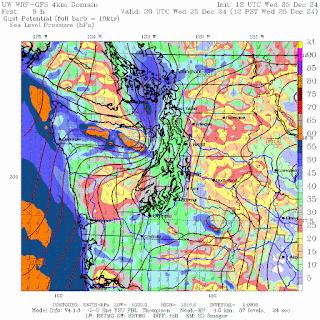
This front will produce very strong winds along the coast and moderate winds over NW Washington (see predicted gusts at noon). VERY strong winds on the lee (NE) slopes of the Olympics.
Stage 2 is more interesting and perhaps more impactful. A moderate low center will pass north of western Washington, producing a very strong pressure gradient across the South Sound.
As shown by the wind gust prediction for 8 AM tomorrow (sea level pressure is also shown), strong winds from Hoquiam through Tacoma could well produce gusts reaching 45 knots. That means power outages. PSE needs to be ready for this.
Still not enough? All the offshore storms will produce massive waves that will reach our coast tomorrow (see below). Waves of 20-30 ft.
This is the kind of weather that brings a smile to the faces of local meteorologists.


.gif)


;)
ReplyDeleteInteresting. We were in N and S Seattle, yesterday and this morning. Then drove to Kitsap County via Tacoma. Noticed gusts while on the Narrows Bridge, but otherwise far more clement weather than I was expecting. Blue skies and sun right now.
ReplyDelete