It is now officially summer.
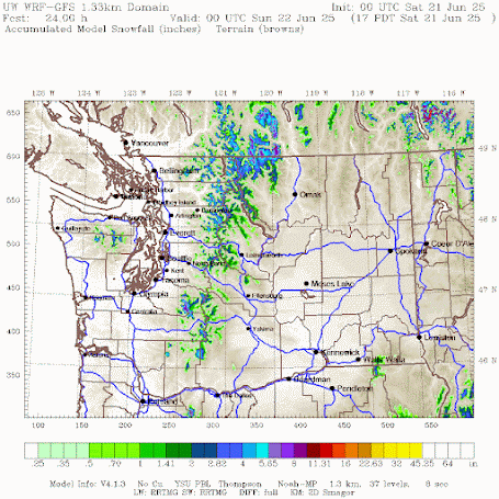
It is now snowing in the mountains above approximately 5000 ft.
Here are some recent cam shots at and near Paradise on Mount Rainier. Paradise is around 5400 ft above sea level.
Perhaps not the best day for a hike. Tomorrow will be far better.


Yes, there's fresh snow on Church Mountain (and even Skyline Ridge) here in Glacier, in Whatcom County. There was lots of June rain yesterday in the lowlands. All this, 'range of normal' in my decades of experience here.
ReplyDelete~0.70” of rain fell around the Bellingham area on the morning of 6/21/25 for a rather soggy first day of summer. Though far from record-breaking, this is the most single-day precipitation that’s fallen here since the latter third of March and the most single-day precipitation during June since 2022. However, even this relative bounty just wasn’t enough to really make any substantive dent in the drought conditions that have rapidly come to dominate the region during the first 3 almost entirely rainless weeks of June. This June will inevitably end up with considerably below normal precipitation.
ReplyDeleteMy backyard weather station is also able calculate a potential evapotranspiration value based on the measurements it records for temperature, humidity, wind, solar irradiance and a laboratory-derived constant based on a grassy surface. So far, there have been just over 3” of pET for the month. So, while the pET:precipitation ratio has improved since this time yesterday (from ~150:1 to ~4:1), based on the current forecast it will quickly diminish by month's end with no more precipitation (at least of any consequence) currently predicted for the foreseeable future.
Furthermore, my station is equipped with a suite of sensors which measure soil moisture and temperature at the rooting depth of the grass which covers my backyard: ~5” below ground surface. Prior to the rainfall we received this morning, soil moisture was already very low compared to the typical value for this time of year (i.e. ~50% saturation vs >70% saturation). The rain came to an end at around 6:30AM and by about 12:30PM the soil moisture had increased by a paltry 2% since this time yesterday.
This dynamic is nicely illustrative of the responsiveness to precipitation of soil moisure for soils of the type that underlay much of the local area. Which is to say that it takes *a lot* of precipitation to substantively increase soil moisture, particularly once the soil begins to dry out in earnest. It’s typical for soils in this area to reach complete desiccation (i.e. no measurable moisture) by mid-August and for that condition to persist into October until enough precipitation has finally fallen to begin to measurably and substantively increase soil saturation.
By the end of the month, with ~0.15" - 0.20” of pET per day, soil moisture will have fallen considerably from its already disconcertingly low level and the soil moisture on July 1 will be the lowest that it’s been on that date since the torrid summer of 2015. There are some larger cottonwoods that grow in my backyard and one adaptation which this species employs to cope with drought conditions, known as cladoptosis, is to drop branches from the canopy via abscission in an effort to decrease the number of leaves through which the tree loses water via transpiration. I’ve only observed this response to occur during periods of notable drought conditions, particularly during late spring and early summer (most recently during the historically dry year of 2023), and I fully expect to see it again this year.
Parkland got rain too.
DeleteThank you for updating the weather scene on a regular basis and for these pictures.
ReplyDeleteI wanted to go ride outdoors but there was a persistent, obvious drizzle that wasn't getting picked up by radar. I didn't really feel like taking a chance so I just stuck with the indoor bike instead. I had the M's game on TV, and while I was riding, two participants in the game (umpire, Mariners player) fell victim to the sweltering Chicago heat and both needed medical assistance. Talk about worlds apart...
ReplyDeleteThe discrepancy between radar imagery and ground truth yesterday was very noticeable! I'm glad I trusted my eyes and instincts and dressed for serious rain, because that's what Olympia got in the morning.
ReplyDeleteAt the time, the Seattle and Langley Hill radars both showed spotty, light rain, which was so clearly wrong I wondered what was going on.
Thats why i rarely leave the safety of my man cave
ReplyDelete