If you were thinking of going on a hike on Friday or Saturday, think again.
Early spring weather---cool and wet--will take over a few days starting on Friday.
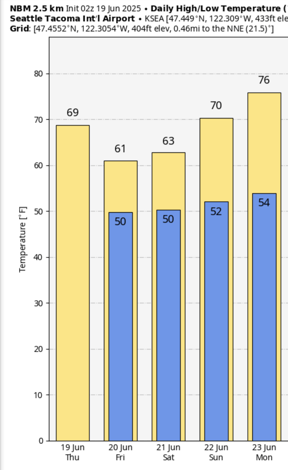
Consider the predicted temperatures in Seattle (below). Only 61F on Friday and 63F on Saturday. Normal highs should be in the low 70s.
But if you want a real shocker, consider Stampede Pass at 4000 ft in the central Washington Cascades. Highs only in the mid-40s and lows in the 30s on Friday and Saturday.
Are you sitting down? The models are going for substantial SNOW above 5000 ft (see accumulated snowfall through Saturday evening below).
Even normally warm Yakima will get chilly, with lows in the 40s on Saturday and Sunday, with highs only reaching around 70°F for a few days.
Precipitation will be substantial for this time of the year, with the mountains getting hit particularly hard (see the predicted totals through Sunday at 5 AM below). An inch in some places.
But the REALLY crazy precipitation will be in Oregon, where up to 3 inches will fall. Nuts.
Why such unseasonable cold and wet weather? An unusually strong upper-level Pacific low will move over our region on Friday and Saturday (see below)
This cool, moist period will help suppress any wildfire starts, resulting in a continuation of a BELOW-AVERAGE wildfire season in Washington State.
Do me a favor....don't tell the Seattle Times ClimateLab folks about this....it will ruin their day.


The upcoming cooler, more moist weather will temporarily ease the current high fire danger here in Eastern Washington but any rain will likely only bring a short reprieve. It has been so dry for so long along the Cascade east slopes that as soon as it warms up again, we will quickly go back into high fire potential. We have also already had some large fires for this early in the season and in higher elevation forest areas where we don't usually have problems until mid-summer.
ReplyDeleteLook at Fuelcast...fuels are very modest. So far wildfire area is well below normal in WA
DeleteFuelcast is calibrated for US rangelands and pastures only. Wouldn't FM100 be a better indicator (which is low as well)?
DeleteThis guy makes forecasts, entertaining and fun, the deep freeze cometh
ReplyDeleteAny assessment of wildfire activity as a percentage of normal at this time of year is akin to assessment of snowpack as a percentage of normal in mid-November. NICC outlooks for Washington and the Northwest are not comforting.
ReplyDeleteLawns and other vegetation in my neighborhood already look as they would in late July or August. It's very dry, and I'm sincerely hoping more fire agencies get burn/fireworks bans out before the July 4th holiday.
ReplyDeleteCliff, I'd like to hear you talk about the origin of this air mass in a future post. 39F in Bend, 41F in Missoula, 41F in Elko at 8 am Saturday. Brrr! Did it come straight from the Bering Sea or what?
ReplyDelete