Several of you have asked for an in-depth look at the forecast failure on Wednesday night. The prediction of severe convective weather that never verified.
This blog will talk about this issue in more depth and note what I think was the real problem: over-reliance on models and the lack of forecast updates by the National Weather Service.
First, the good news. Weather prediction models skillfully predicted the passage of a line of thunderstorms on Wednesday evening several days in advance.
To illustrate, the figure below shows the observed radar imagery at 7 PM Wednesday (left panel, yellows and reds indicate the heaviest precipitation), while the right panel presents the predicted radar at the same time (from a 26 hr model forecast).
Really not bad....the model overdid things a bit, but the general pattern....a line of strong storms moving northwards--was forecast over a day in advance.
We knew it would rain. That thunderstorms with lightning would move through that evening.
30 years ago, we could not have done this with any skill. Real progress.
The Severe Weather Forecast That Did Not Verify
Weather models were predicting extreme values of key convective parameters, such as CAPE (Convective Available Potential Energy), a measure of how much energy would be available to drive thunderstorms.
Predicted values exceeded all-time observed records for this season...which alone should have raised some suspicions. The Northwest is not Oklahoma and there are huge complexities forced by terrain and land-water contracts. Complexities that are often poorly handled by NOAA's and other models--such as the inability to maintain shallow cool air near the surface.
Storm Prediction Center graphics indicated that the severe thunderstorm threat would cover a very broad area (see map below): much larger in area than even the extreme model projections.
To prove this to you, consider the HRRR model 34-h forecast of CAPE (again instability) for 3 PM Wednesday. The most extreme values were only along the western slopes of the Cascades, with MUCH less threat near Puget Sound. Most of the region would never get extreme thunderstorms.
In contrast, the NOAA Storm Prediction Center graphic shows major threats extending over a much broader area. Not good.
This error was repeated in the Seattle NWS Office for tornado and severe winds outlooks.
An Even More Serious Problem
Human forecasters should really earn their pay by continuously monitoring the fidelity of the model forecasts and letting the public know when the forecasts are failing....and what they think will really happen.
By early afternoon on Wednesday, it was clear that model forecasts were going seriously wrong and that the chances of severe convection over western Washington were essentially nil.
For example, the instability forcing thunderstorms is driven by low-level warm temperatures, which help produce a large change in temperature with height.
But it was clear that cool air was holding and that predicted surface temperatures were much cooler than expected.
Want the proof? Here are the model-predicted temperatures and actual temperatures (orange dots) from the state-of-the-art UW forecast system prediction started the morning of the previous day. The NOAA models did the same thing.
The observed temperatures were MUCH cooler than the forecasts. Fatal for the thunderstorm forecasts.
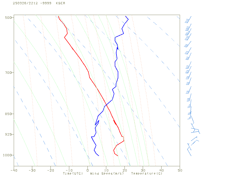
But the problems were worse than that! Easterly winds were developing aloft, with sinking and warming air above the cool low-level air. This situation was being observed in real time by aircraft coming in and out of Seattle and Portland.
The aircraft vertical profile at 3 PM is shown below. The red line is temperature, and the Y-axis is height.
A strong low-level inversion existed with temperature warming with height....this is fatal for severe convection.
Any reasonably trained meteorologist should have recognized that the severe weather threat was toast, and this message needed to get to the public and the media, who had been headlining the threat of tornadoes, hail, and powerful winds.
I was not a little disappointed that the Seattle NWS office did not realize what was going on and did not put out a message about the threat being over.
When it became clear that they were not doing so, I decided to put out a blog about it.
The amateur weather sites, who so hyped the threat on YouTube and BlueSky/X, did not pull back either.
The Seattle NWS got a lot of complaints on their social media and put out a graphic "explanation" of the failure (see below). Not satisfactory.
Bottom Line
Weather prediction has gotten immensely more skillful during the past decades. But as good as models have become, they still have failure modes, and this event played to them (e.g. over over-mixing of shallow cool air, complex orographic effects, and more).
Experienced human forecasters are still needed to catch model failures and to make necessary adjustments to ensure the public is not underwarned or overwarned.
Clearly, the NWS could have done much better in this case and I think a serious review is in order.


.jpeg)


this part "Human forecasters should really earn their pay by continuously monitor the fidelity of the model forecasts and let tin the public know when the forecasts are failing....and what they think will really happen." is what infuriates me most about the Youtube kids calling themselves forecasters now. they're literally just regurgitating models with no apparent understanding of any actual science. no one's letting them live it down though lol. the boy who cried wolf finally made a fatal error.
ReplyDeleteThanks, Cliff!
ReplyDeleteIn defense of the NOAA/NWS forecasts, the prediction was always for a "slight" potential of severe weather. Based on the media and social media, you would think they were predicting a moderate - high probability event. The probability of severe wind gusts and tornadoes was in single digits to low teens, although the hail potential was a bit over done, especially since hail occurred over the Olympic Peninsula, where the forecast was for even lower potential. One lesson here is to not over-hype a low probability event, and to better communicate to the public that forecasts of high impact weather usually come with large uncertainties.
ReplyDeleteThis is what i was trying to tell people around me too. That all these things like hail and tornadoes (lol) were all based on the main low probability event happening FIRST. But that's kinda the problem, the social media weather nerds wouldn't stop acting like the super cell event was guaranteed to happen. I saw several that were guaranteeing widespread large hail at the very LEAST. Very irresponsible.
DeletePrecisely. The graphic in this post says "up to 15-29% chance of severe hail" and "5-14% chance of severe wind gusts". Ignoring the mathematically nonsensical "up to", that means 71-85% chance of NOT severe hail and 86-95% chance of NOT severe wind gusts. A forecast is a statement of probabilities, not a prediction. Regardless of which happened, the forecast was not "wrong". Humans have a hard time interpreting probabilities, and the media rarely helps.
DeleteBeyond this. Cliff seems to be saying that the forecast should have been changed to have even lower probabilities of severe hail and wind, and I'm sure he knows what he's talking about. But it sounds like the original forecasts were accurate statements of the probabilities at the time they were issued.
Mark... with that hail probability 15-29% of the area should have had extreme hail. The truth was the ZERO locations had hail. Not a good forecast..cliff
DeleteThis comment has been removed by a blog administrator.
DeleteThis comment has been removed by a blog administrator.
DeleteThis comment has been removed by a blog administrator.
DeleteI was also surprised the NWS did not update the forecast discussion throughout the day. The 930am discussion mentioned that forecast was still on track, but by at least 1 or 2pm, if not later, no update. On such an important forecast that had everything shutting down around town, no updates on the atmosphere’s status throughout the day was shocking to me. I’m originally from OK and by 1pm, you could tell the moisture was around, but the early storm tracks passing through and low/mid 60s afternoon temps were limiting the chances of stuff really blowing up. In the late afternoon when the sun did break out a bit, it was too late. May sunshine might have caught up, but I don’t think mid March sun had a chance.
ReplyDeleteMy Google weather app hourly forecast seems to be getting worse, I don't know if that reflects models it checks back to not being updated. I have a different radar app that had this feature of modeling precip an hour or 2 into the future and now it does only 30 minutes. Mostly this is relevant to my bike commuting, should I leave the office a little early or a little late...
ReplyDeleteI have gotten to where I don't really put much credence in the local news stations when it comes to the topic of weather and usually just rely on this blog to help me understand upcoming extreme weather - it has gotten so much right compared with the sensationalistic slant of the news stations.
ReplyDeleteI have gotten to where I don't put any credence in the local news stations, regardless of the topic. They have completely lost all credibility. Never turn them on for any reason.
DeleteDid the meteorologists in the Seattle NWS not realize the threat was over, or did they not know the stories on the TV were exaggerated and then wrong. Do they have the phone numbers of media folks?
ReplyDeleteI am by no means a weather expert but I do have an amateur weather station in my back yard. When I saw the 2:00 PM temperature was only 65, I commented to my wife, "Hmmm. Not getting the predicted warming. Looks like the severe weather forecast is toast."
ReplyDeleteNow that the forecast for the next few days has come into better resolution, it appears that KBLI has never had a March which was both as anomalously warm and anomalously wet as that of 2025.
ReplyDeleteThere have been Marches which were wetter and Marches that were warmer but never one in which the average temperature was as anomalously warm while precipitation was so anomalously high.
In fact, with 3.16” of rainfall (the normal monthly total is 3.36”), the 7-day period from 3/21 - 3/27 was the 5th wettest 7 day period recorded during any March in the POR and the only 7-day period among the top-5 that didn’t occur during 1982.
We could certainly use a break as soils are nearly saturated and sensitive plants in our gardens need some time to dry out!
I have to say that the U.S. Drought Monitor showing Western Whatcom County as “abnormally dry” is quite incongruous with the precipitation anomaly maps for the state available via the Western Regional Climate Center.
ReplyDeleteAt no timescale for which data is available (from the past 7 days, to the past 14 days, to the past 30 days, to the past 60 days, to the past 90 days, to the past 6 months, to the past 12 months, to the past 24 months, to the past 36 months, as well as for the current month, since January 1, since April 1, 2024, since July 1, 2024, and since October 1, 2024) has this part of the state been calculated to have received less than 90-100% of normal precipitation for any aforementioned time period and for the majority of those, precipitation has been anywhere from comfortably above to nigh-historically above normal.
If generally above normal precipitation over a wide array of timescales from the very recent past to multi-year periods somehow translates to an assessment of “abnormally dry”, then it stands to reason that the Drought Monitor is similarly guilty of the “boy who cried wolf” phenomenon that other commenters have attributed to the recent forecasts for severe weather in Western Washington.
Some significant echoes visible on radar under clear skies this evening over NW Washington/Georgia Basin; migratory birds?
ReplyDelete"The outlook products were scientifically sound." No they were not sound. This has been my complaint with the local NWS offices. Over reliance on forecast models and no knowledge of our local terrain features. The NWS did the exact opposite thing they should have done post-storm: defended a bad forecast. It would have gone a lot better for them had they just admitted they did a poor job with this forecast and will learn from it going forward. Instead we get a defensive explanation for why the forecast was "scientifically sound." Cliff is right, a serious review is in order, and if we the people and expert forecasters such as Cliff do not hold them accountable for such poor job performance, who will?
ReplyDeleteCliff, can you recall instances of large/damaging hail 1-2 inches++ in Western WA? I cannot recall this at any time...
ReplyDeleteIn Portland our high got up to around 83F that afternoon...I thought for sure that would count for something, storm-wise. That was several degrees above forecast. But the RH on my Wx station was around 30% during peak temps - kind of dry for severe weather, right? I'm wondering if that was the dry offshore wind you mentioned, a deal-killer.
ReplyDeleteI don’t think this was a failure by any means. The severe thunderstorm watch was definitely warranted even with conditions not being perfect. There should have been at least one severe storm warning for the storm that produced the hail over the Olympics. Most people around here don’t understand what a watch means and don’t understand how to read forecasts like this and so they see wordage about a chance for tornadoes and think it’s going to be like the movie Twisters. Anyone that has spent time in the Midwest knows how this works. There were reliable real time forecasters on YouTube and even Facebook indicating that the cooler temps would likely reduce the severity of the outbreak.
ReplyDeleteMight be a moot point: "Project 2025, the Heritage Foundation’s right-wing blueprint for the Trump Administration to "take down the Deep State," calls for breaking up and downsizing NOAA, including commercializing forecasts by the National Weather Service." And they are walking the talk "The NWS, which is staffed around the clock, has lost about 10% of its workforce in recent days. But current and former Noaa scientists and officials that the Guardian consulted say the NWS cuts fell haphazardly, leaving some forecast offices in a much worse staffing position than others.
ReplyDeleteI'm baffled at how they overforcast that storm and then absolutely no one warned us in the foothills about the massive east wind we're having today. Second worst storm of the year and nary a mention.
ReplyDeleteNWS Portland's AFD said a 1pm special balloon revealed issues that would interfere, but I did not see any resulting changes to the forecast.
ReplyDeleteIs there a chance that this is the future of NWS forecasting? I believe the new administration is cutting staff throughout the government, and has a specific desire to cut or eliminate government weather forecasting. We may have a future where there is no staff to monitor the weather models.
ReplyDelete