Severe thunderstorms were forecast for tonight....but they won't be as severe as some have predicted.
Why? Because cool air has held in at low levels.
Take a look at the vertical profile of temperature at SeaTac Airport at 4 PM based on aircraft landing and taking off.

Cool air in the low 60s at the surface and warmer temperatures aloft (the dots are the temperatures). This is not good for severe thunderstorms, which like temperatures warm at the surface with rapid cooling in the vertical.
The latest NOAA HRRR forecasts are recognizing the "cold problem" and are backing off the strong thunderstorms. This is illustrated by the forecast of simulated radar reflectivity for 9 PM, which shows a weakened and delayed line of showers.

The forecast for 11 PM is essentially the same story (see below). Some showers, gusty winds, and lightning, but no severe weather

The 6 PM radar image shows showers to the south, with some being strong (red). Note that the strong ones are heading to the western Cascade slopes.

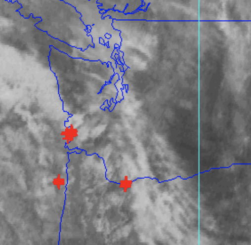
The 5 PM lightning strikes in the incoming band is unimpressive:
Cold air holding in at low levels is a persistent model problem, and one reason I tried to dampen some of the excess enthusiasm for this event.


What does this mean for the hail forecast?
ReplyDeleteWhat do you think it means?
DeleteIt means full fail
DeleteIt means full fail
DeleteI left my office in Bothell at around 230 pm, around the time the brief showers this afternoon. The temp dropped from 65 when I left the office to 60 by the time I arrived at my home in Kirkland at 3. Seeing how cool it was, I definitely had the impression that this probably had a dampening effect on CAPE, felt like there wasn't enough solar heating time left in the day to get the temps back. Cliff, do the computer models take into account the dampening effect of these advance showers?
ReplyDeleteThis comment has been removed by the author.
ReplyDeleteThis comment has been removed by the author.
ReplyDeleteThis comment has been removed by the author.
ReplyDeleteSorry for the spam. I didn’t know it takes time for approval. Whoops
ReplyDeleteThere probably isn't going to be any! At least not golfball size.
ReplyDeleteI was wondering about the temps it wasn't that warm here in the Puyallup area and cloud cover most of the day. looks pretty run of the mill not even as much lightning as that one in late summer last year. Hypesters take another L i guess lol.
ReplyDeleteSo, why are thunderstorm predictions so difficult? Not the first time. Looks like two hours ahead is about the best that can be done.
ReplyDeleteDoes this hold the same for the south sound. Puyallup, south hill, boney lake area. Thanks
ReplyDeleteDo you mean there was an inversion? So the atmosphere was effectively capped?
ReplyDeleteCliff, was this a bad human prediction or fallout from too much AI being used in meterology today?
ReplyDeleteAbsolutely stunning and beautiful incoming storm views from the Space Needle web cam at 6:50PM, 7:00 PM, 7:10 PM, 7:20 PM, and 7:30 PM for March 26, 2025.
ReplyDeletehttps://spaceneedle.roundshot.com/#/
I not only noticed that it was much colder than forecast this morning at my location in Bellingham and that persistent cloud cover kept temperatures in the 50s for most of the day, but also that temperatures in the mountains were quite warm today. The high point of the Mount Baker Ski area at ~5000’ was in the low 60s during the late morning-early afternoon and even now temperatures are in the 40s as high as ~7000’ near Mt. Rainier!
ReplyDeleteI thought steep lapse rates were essentially a prerequisite for strong thunderstorms and wondered if there was some mechanism or forcing at play with which I was not familiar that was informing the predictions of severe thunderstorms/the formation of supercells, but it looks like my understanding of the relevant dynamics was accurate and that my observations explain why this event has underperformed the forecasts.
Yes- Puget Sound with its low temps took some of the CAPE away, as Cliff said. I think the TV forecasters around here don't get enough exciting weather so they hype what they can to get the attention. Unlike the forecasters living in the SE US who have lots to talk about!
DeleteNothing but "Storm flatulence" happening here in S. Everett, at 8:50pm. No big deal, no hail yet.
ReplyDeleteYou nailed it. With temps in the low to mid 50s at noon, it was not looking promising for severe weather.
ReplyDeleteThank you. Always appreciate the accuracy of your forecasts. It definitely didn't get as warm as expected. Heard some rumbles here but nothing very close.
ReplyDeleteA more detailed explanation of the deficiencies of the forecast would make for an interesting blog post. What were the mechanisms that led to unexpectedly cool air in the lower levels? Why is the tendency of models to unrealistically displace cold air at the lower levels?
ReplyDeleteHow did the atmosphere defy expectations and why?
I second this!! Cliff we want your post mortem!!
DeleteThe atmosphere didn't defy expectations. Rather, the expectations were broad, because it was a difficult scenario to forecast precisely. The National Weather Service forecast thunderstorms and precipitation, including a 15-29% chance of damaging hail.
DeleteThat forecast is consistent with what occurred.
One might not feel that is enough certainty to bother making a fuss out of, but when the consequence is weather serious enough to damage property and injure people, it's better to advise people to prepare just in case.
Cliff’s most recent blog post further repudiates your comment.
DeleteBIGGEST HORSE SHIT weather prediction of all time. NOT from Cliff but from all these other Click Bait Forecasters on Seattle TV and social media meteorologists. They were talking tennis sized hail then egg sized hail. Then today I watched TV (all local channels) and you could slowly see them try to wriggle out of these predictions… “maybe”, “localized”, “perhaps”. ALL BULLSHIT, they kept pumping worst case Scenarios. All for clicks or views. FUCK THEM ALL.
ReplyDeleteNot Cliff, I appreciate he isn’t in it for the clicks, he just loves weather.
Local firecast went from chicken egg size hail to goose egg and than on to dinosaur egg. I was like “shut the front door aren’t those mammals”?
DeleteMy thoughts exactly. Really tired of both groups.
Delete2 questions..
Delete1. Why do you watch them if they're not good at what they do?
2. Can you describe the causes of your neediness to spread nasty profanity?
It started off w such promise! We were shopping at Costco when my wife asked me why I was sweating. Got home to check the weather station and humidity was 90%! We had a few nice bolts of lightning here up north but disappointed as I love a good t storm. We ask a lot of our forecasters—none better than Cliff. Keep it coming Cliff I always appreciate your insight.
ReplyDeleteBobby Seattle said it best, all the click bait TV and internet "forecasters" called yet another "end of days" situation that turned out to be nothing. Now, I'd much rather this than the opposite and I was very happy to be hearing ZERO thunder and the worst we got in the Grand Mound area was two waves of heavy rain (but even that wasn't the stuff I knew growing up in Florida).
ReplyDeleteCliff, you called it correctly yet again. That's what happens when you're more focused on the hard data than scaring the crap out of people.
If they aren't good at what they do, why do you watch them?
DeleteI thought I remembered reading once (maybe in this blog) that the NWS Severe Weather Prediction Center in Norman, Oklahoma uses modeling that does not take into account our terrain and cold Puget Sound waters in their forecasting. If that's the case, it's no surprise that the storms were much less severe than forecast.
ReplyDeleteTo misquote Shakespeare: Much Ado About Not Much!...however, one scary moment did happen last evening. A lightning bolt apparently hit close to my house--and the entire house actually shuddered, for just a moment!. I thought that a mini-earthquake had happened! I never have experienced such an event. And overall, the lightning show was no big deal.
ReplyDeleteWell, on the Bothell-Mill Creek line, I got a typical NW thunderstorm. OK for here, but anyone from the Midwest, the East, or the Rockies would just laugh at it. There was about 1/2 inch of rain, no high winds, hail, or close-by lightning strikes (within about a mile).
ReplyDeleteI might add, there was a storm last August here that was at least the equal of this. The one in May, 2017 far surpassed it.
ReplyDeleteIt looks like the northern portions of Western Whatcom County were the big winner as far as precipitation totals from this event with most locations receiving >1” and one spot northeast of Lynden with 2”!
ReplyDeleteI was thinking the same as wff255. My guess is that Norman NWS is not taking into account our coastal mountains and oceanic or puget sound temps. Plus, maybe NWS is understaffed right now? Sadly, our school district here in Olympia cancelled all high school sports activities on arguably the nicest afternoon of the year. instead of playing softball outside in 68 degrees, my daughter was inside playing with social media. I wonder how much time we waste nationally on bogus media-driven weather reports each year.
ReplyDelete