November 21, 2012

Intense Convective Line

Sometimes a weather feature comes through that grabs your attention, providing a sobering reminder of the power of the natural world.  Yesterday, we got hit by such a feature--an intense convective line that brought strong winds, intense rain, and a cloud feature that was nearly biblical in appearance.

First, a picture, graciously provided to us by Peter Loron, of the line as it was approaching downtown Seattle (time: 1:30 PM Thursday).  Looks like the end of the world.   

Picture courtesy of Peter Loron.  Looking towards W. Seattle from downtown.
Would have been fun to be on the big white wheel! Or scary.
 Another view of the line was provided by Paul Gockel, taken mid-span on the 520 bridge:

Picture courtesy of Paul Gockel
You see that linear appendage hanging below the main cloud base? Those threatening clouds (also known as shelf clouds) are found along the leading edge of the gust front;  cool air descends out of the cumulonimbus cloud and forces air in front of it to rise, producing the cloud  (see schematic below).

Schematic of gust front and shelf cloud
 For your viewing pleasure, here is another dramatic shelf cloud.

We could see the convection (big line of cumulonimbus clouds) in the Camano Island radar image at nearly the same time (yellow is heavy rain, red is VERY heavy rain or hail).


There was one lone lightning strike (over north Seattle as this feature went through).

As it went past the UW, the winds gusted to 30 kts, the wind directed shifted to southwesterly, heavy rain fell, pressure jumped, and temperature fell (look just past 21z on the UW rooftop observation plot below).

Or you could view the system from the cam on the roof of my building.  Here are images before, during, and after passage of this line:


One interesting aspect of this feature is one could follow it from offshore, using the Langley Hill radar.   Here is an image at 10:48 AM Tuesday...clearly apparent offshore.


Hopefully, during the next year we can extend Seattle RainWatch to include the Langley radar to provide an automated heads up for features such as this one.

November 19, 2012

Hurricane Force Winds Hit the Region

Well, if heavy rain was not enough, hurricane-force winds--stronger than the winds during Hurricane Sandy--hit our coastal areas today.

Several sites had wind gusts above 100 mph, including 114 mph at Naselle Ridge on the southwest Washington Coast (sustained winds reached 77 mph).

Or 111 mph at nearby Abernathy Mountain.  Both of these sites are at roughly 2000 ft.

But even sites near sea level got blasted.  Much of the southwest Washington coast and Oregon coast had wind gusts to 60-80 mph with extensive power outages and damage.

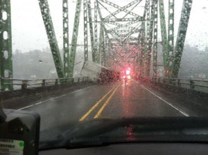
A trucker decided to cross the Columbia River bridge near Astoria near the peak of the wind event (around 10 AM this morning)....and he didn't make it:


Some other impressive reports from the NWS Local Storm Report system included:

1102 PM NON-TSTM WND GST PACIFIC CITY 45.20N 123.96W
11/18/2012 M 75.00 MPH TILLAMOOK OR MESONET

1232 AM NON-TSTM WND GST NEWPORT 44.63N 124.05W
11/19/2012 M 80.00 MPH LINCOLN OR MESONET

1249 AM NON-TSTM WND GST YAQUINA HEAD 44.67N 124.07W
11/19/2012 M 98.00 MPH LINCOLN OR MESONET

0850 AM NON-TSTM WND GST LINCOLN CITY 44.97N 124.01W
11/19/2012 M 85.00 MPH LINCOLN OR MESONET

0855 AM NON-TSTM WND GST GARIBALDI 45.56N 123.91W
11/19/2012 M 84.00 MPH TILLAMOOK OR MESONET

Many trees are down--some examples from the Astoria newspaper:


Want to see an amazing video on the Columbia River's South Jetty?  Click on the image:
http://www.youtube.com/watch?feature=player_embedded&v=e7HX3J2ENYY
 The high resolution models suggested a significant wind event, although they underplayed the intensity and northern extent.  Here is the wind gust forecast from Sunday morning for 7 AM this morning.  Some 70 kt winds.  The reason the model underplayed the event was an inability to correctly simulate a small scale low center that moved towards the central WA coast.  The Langley radar showed it in real time, though.

Now the good news.  After two modest systems pass through tomorrow and Wednesday, Thanksgiving Day looks fairly dry.  And the next system on Friday/Saturday has weakened compared to major event predicted a few days ago.  No big snowstorms this week, but enough more to allow Baker and Crystal to open.

A Wet Transition for the Pacific Northwest

This week, a very El Niño-like atmospheric pattern is bringing needed precipitation to central and northern California. Reservoirs are filli...