August 04, 2016

Seafair Weekend Forecast: A Lazy Low Visits

Few forecasts are more important in Seattle than the one for Seafair weekend, and this weekend will be a mixed bag.  If you need to pick one day for outdoor activity, Saturday should be the better day.


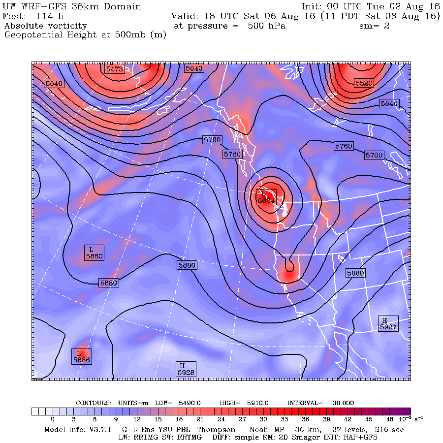
The issue is that our nemesis, an upper level trough of low pressure, will be approaching and greatly influence our region Sunday and Monday.   Here are a series of 500 hPa (about 18,000 ft) upper level maps.

Friday morning (at 5 AM)....a low to our northwest.


Saturday morning, it slowly easing southeastward.

 Sunday AM, this lazy low is slowly heading south.

 Finally, on Monday morning, this sleepy low has barely moved past us.


What a contrast to last year, when ridging (high pressure) was the rule.

With a low hanging around, temperatures will be 5-10F below norming (upper 60s).

Precipitation?   Nothing on Saturday and early Sunday before early afternoon will be dry.  Thus, the Seafair festivities will generally be fine.  But later in the afternoon, the combination of upward motion from the trough and surface heating will result in the formation of convective showers (including thunderstorms), as suggested by the forecast precipitation for the 3-hours ending 5 PM on Sunday.   The greatest threats will be over the coastal zone and NE Washington.


As the upper low moves by, the showers will rotate northward into western WA.   The 48-h totals ending 5 AM Tuesday are impressive along the coast and over southern BC and Alberta, with some areas getting more than an inch (pink and black colors).


The big worry?  lightning.   The models are suggesting lots of instability on Sunday and Monday and thunderstorms can be expected.   So there may be a lot of smoldering fires ready to rev up with warmth and wind next week.


August 02, 2016

Northwest Wildfire Season Has Begun

After a below average number of fires and acres burned during the first half of the summer, the fire season finally started in our area.   As shown by the large fire map of the Northwest Interagency Coordinating Center (below), about 8 fires are now burning over the Northwest.  Nearly all of them are flashy grass fires at lower elevations.


These fires have also started the mid to late summer smoke season, as indicated by a high-resolution MODIS satellite image from Monday afternoon.  Look carefully and you will some subtle smoke around Hanford and over Idaho.


Two days ago, there was even a modest fire in the Olympics, as shown by this aerial shot taken by Ed and Clare Kelm of Roche Harbor.  I flew in from the west that day and saw some of the smoke in Olympic valleys myself.


Why the fires now?  The key factor was the surge of warmth last week.  The plot of temperatures at Pasco, Washington for the past few weeks says it all, with temperatures rising above the mid-90s for 6 days in a row, which drops the relative humidity way down and dries out the surface fuels (like grass).
What ignited the fires?   Either careless humans or lightning.   Although the last few days has had little lightning, there was plenty a week ago.  A lightning strike can produce a smoldering, low-level fire that explodes when temperatures surge.

There is no reason to expect an above normal fire season this year.  Streamflow, snowpack, and soil moisture are near normal, and the short-term drought indicator (produced by NOAA) shows nominal conditions.

And as noted by previous blogs, an upper level trough is bearing down on us (see upper level map for today at 8 AM) and we expect precipitation during the next day or so in the mountains and western


Washington (see 72h totals below).  We do expect some lighting with the rain, so that could initiate fires.

We do appear to be in a cooler pattern, with another cool/wet lupper ow ready to move in for this weekend (see upper level map below).  Model forecasts suggests that this will be a wetter system (and yes, this is supposedly the driest time of the year).


I suspect that this summer we will end up with below-normal numbers of wildfires and acres burned, due to the relatively moist antecedent conditions and the atmosphere's new and consistent configuration of troughing over the Northwest.  Time will tell.

Tens of Thousands Have Lost Power as a Strong Cyclone Makes Landfall

As the models predicted, a strong storm with powerful winds is moving across our region, and nearly 100,000 customers are without power as I...